Sampling grids to support the collection and analysis of survey data for the National Coral Reef Monitoring Program in American Samoa, Pacific Remote Islands Areas, Main Hawaiian Islands
The sampling grids are identified as essential components for the stratified random sampling design of the National Coral Reef Monitoring Program (NCRMP). The benthic habitat map layers including bathymetry, hard and soft substrates, reef zones and sector...
American Samoa: coral reef monitoring interactive map and information layers primarily from 2010 surveys
This interactive map displays American Samoa data collected by the NOAA Coral Reef Ecosystem Division (CRED) during the Pacific Reef Assessment and Monitoring Program (RAMP) cruises. The information presented is a combination of standard CRED monitoring s...
Eco-spatial data layers of coral reef ecosystem drivers in American Samoa
Understanding the spatial distribution, intensity, overlap, and cumulative impact of human activities and environmental stressors is essential for effective management and protection of ecosystem services generated by coral reefs. The data described here ...
Dominant Benthic Structure and Biological Cover Habitat Maps for West Maui and West Hawaii
Benthic habitat maps depict dominant substrate type and biological cover in depths between 0 and ~150 m for two priority sites in the Main Hawaiian Islands; the NOAA Habitat Blueprint West Hawaii Focus Area (WHFA) and the Hawaii Division of Aquatic Resour...
Bathymetric Position Index (BPI) Structures Grid Derived from Gridded Bathymetry for Select U.S. Coral Reef Locations across the Pacific Ocean
Bathymetric Position Index (BPI) Structures are derived for islands and banks across the U.S. Pacific Islands Region from a focal mean analysis on bathymetry and slope, and were created using the Benthic Terrain Modeler. Cell values represent one of 13 cl...
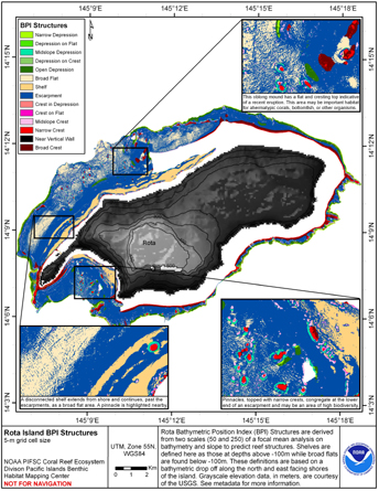
Bathymetric Position Index (BPI) Structures 5 m grid derived from gridded
bathymetry of Rota Island, Commonwealth of the Northern Mariana
Islands (CNMI), USA.
BPI Structures are derived from two scales of a focal mean
analysis on bathymetry and slope. The grid is based on
gridded (5 m cell size) multibeam bathymetry, collected aboard NOAA
Ship Hi'ialakai and R/V AHI, and it was created using the Benthic
Terrain...
Bathymetric Position Index (BPI) Zones Grid Derived from Gridded Bathymetry for Select U.S. Coral Reef Locations across the Pacific Ocean
Bathymetric Position Index (BPI) Zones are derived for islands and banks across the U.S. Pacific Islands Region from a focal mean analysis on bathymetry and slope, and were created using the Benthic Terrain Modeler. Cell values represent one of 4 classes ...
Rugosity Grid Derived from Gridded Bathymetry for Select U.S. Coral Reef Locations across the Pacific Ocean
Rugosity is derived for islands and banks across the U.S. Pacific Islands Region primarily from gridded multibeam bathymetry collected aboard NOAA Ships Hi'ialakai and Oscar Elton Sette, and aboard R/V AHI (Acoustic Habitat Investigator) from 2003 to 2012...
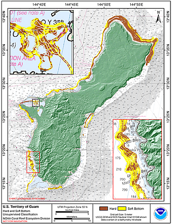
CRED Preliminary hard and soft bottom seafloor substrate map
derived from an unsupervised classification of gridded
backscatter and bathymetry derivatives at the U.S. Territory of Guam.
Preliminary hard and soft seafloor substrate map derived
from an unsupervised classification of multibeam backscatter and
bathymety derivatives at the U.S. Territory of Guam. The
dataset was derived using Reson 8101 backscatter data, bathymetric
variance ...
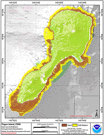
Preliminary hard and soft bottom seafloor substrate map
derived from an unsupervised classification of gridded
backscatter and bathymetry derivatives at Pagan Island, Commonwealth
of the Northern Mariana Islands (CNMI).
Preliminary hard and soft seafloor substrate map derived
from an unsupervised classification of multibeam backscatter and
bathymety derivatives at Pagan Island, Commonwealth of the
Northern Mariana Islands (CNMI). The dataset was derived using Reson
8101 ...
 Sampling grids to support the collection and analysis of survey data for the National Coral Reef Monitoring Program in American Samoa, Pacific Remote Islands Areas, Main Hawaiian Islands
 This interactive map displays American Samoa data collected by the NOAA Coral Reef Ecosystem Division (CRED) during the Pacific Reef Assessment and Monitoring Program (RAMP) cruises. The information presented is a combination of standard CRED monitoring s...
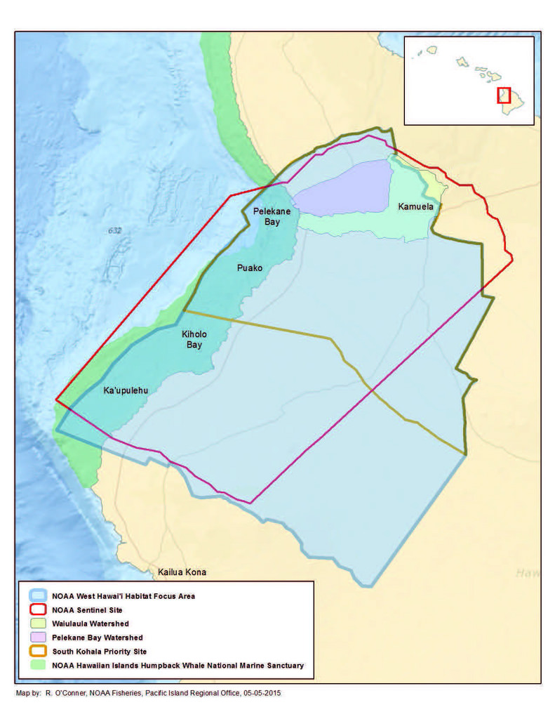 Benthic habitat maps depict dominant substrate type and biological cover in depths between 0 and ~150 m for two priority sites in the Main Hawaiian Islands; the NOAA Habitat Blueprint West Hawaii Focus Area (WHFA) and the Hawaii Division of Aquatic Resour...
 BPI Structures are derived from two scales of a focal mean
analysis on bathymetry and slope. The grid is based on
gridded (5 m cell size) multibeam bathymetry, collected aboard NOAA
Ship Hi'ialakai and R/V AHI, and it was created using the Benthic
Terrain...
BPI Structures are derived from two scales of a focal mean
analysis on bathymetry and slope. The grid is based on
gridded (5 m cell size) multibeam bathymetry, collected aboard NOAA
Ship Hi'ialakai and R/V AHI, and it was created using the Benthic
Terrain...
 Preliminary hard and soft seafloor substrate map derived
from an unsupervised classification of multibeam backscatter and
bathymety derivatives at the U.S. Territory of Guam. The
dataset was derived using Reson 8101 backscatter data, bathymetric
variance ...
Preliminary hard and soft seafloor substrate map derived
from an unsupervised classification of multibeam backscatter and
bathymety derivatives at the U.S. Territory of Guam. The
dataset was derived using Reson 8101 backscatter data, bathymetric
variance ...
 Preliminary hard and soft seafloor substrate map derived
from an unsupervised classification of multibeam backscatter and
bathymety derivatives at Pagan Island, Commonwealth of the
Northern Mariana Islands (CNMI). The dataset was derived using Reson
8101 ...
Preliminary hard and soft seafloor substrate map derived
from an unsupervised classification of multibeam backscatter and
bathymety derivatives at Pagan Island, Commonwealth of the
Northern Mariana Islands (CNMI). The dataset was derived using Reson
8101 ...