
Benthic Habitat Maps for Rose Atoll Marine National Monument in American Samoa from 2004 to 2010
Benthic habitat maps for Rose Atoll, American Samoa were derived from high resolution, multispectral satellite imagery for 2004, 2006, and 2010. The benthic habitat maps for 2004 were previously generated by NOAA's NCCOS's BioGeography Branch before this ...
Northeast Puerto Rico and Culebra Island - Benthic Habitat Map 2015
This benthic habitat map was created from a semi-automated habitat mapping process, using a combination of bathymetry, satellite imagery, aerial imagery and underwater videos to classify the 0-35m deep benthic habitats of the region around Northeast Pue...
Integrated hard and soft bottom seafloor substrate map of Rose Atoll, American Samoa
combining NOAA Pacific Island Fisheries Science Center Coral Reef Ecosystem Division
hard-soft substrate maps with NOAA Center for Coastal Monitoring and Assessment Biogeography
Program shallow-water benthic habitat map of American Samoa.
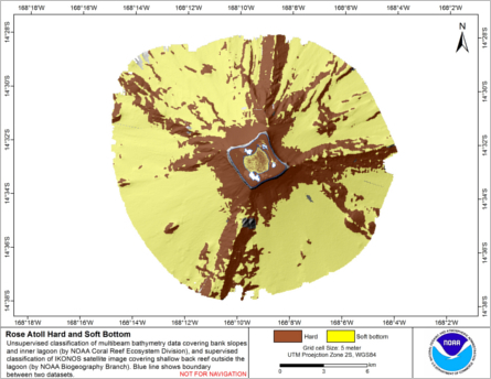
Hard and soft seafloor substrate map, derived from integrating two existing map
products: hard and soft substrate maps derived from an unsupervised classification of multibeam
backscatter and bathymetry derivatives, produced by NOAA Pacific Island Fisheri...
Principal Components Analysis (PCA) Image used to characterize the complexity of the seafloor around St. John, USVI
Eight complexity surfaces (mean depth, standard deviation of depth, curvature, plan curvature, profile curvature, rugosity, slope, and slope of slope) were stacked and exported to create one image with several different bands (each band representing a spe...
Preliminary hard and soft bottom seafloor substrate map (40m grid) derived from an unsupervised classification of gridded backscatter and bathymetry derivatives at Rose Atoll, Territory of American Samoa, USA.
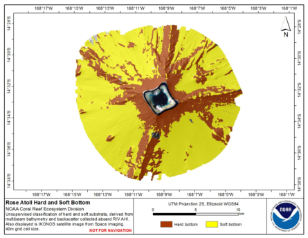
Preliminary hard and soft seafloor substrate map derived
from an unsupervised classification of multibeam backscatter and
bathymetry derivatives at Rose Atoll, Territory of American Samoa, USA.
The dataset was created from gridded (40 m cell size) multibe...
Preliminary hard and soft bottom seafloor substrate map (5m grid) derived from an unsupervised classification of gridded backscatter and bathymetry derivatives at Rose Atoll Lagoon, Territory of American Samoa, USA.
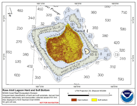
Preliminary hard and soft seafloor substrate map derived
from an unsupervised classification of multibeam backscatter and
bathymetry derivatives at Rose Atoll Lagoon, Territory of American Samoa, USA.
The dataset was created from gridded (5 m cell size) m...
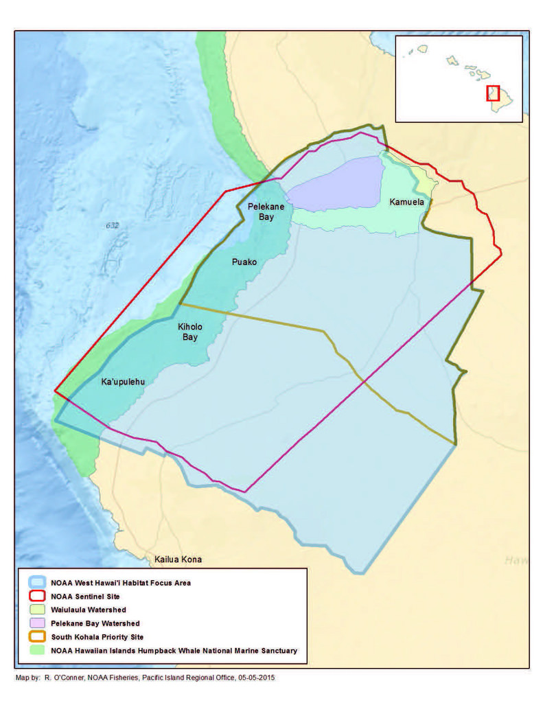 Benthic habitat maps depict dominant substrate type and biological cover in depths between 0 and ~150 m for two priority sites in the Main Hawaiian Islands; the NOAA Habitat Blueprint West Hawaii Focus Area (WHFA) and the Hawaii Division of Aquatic Resour...
 Hard and soft seafloor substrate map, derived from integrating two existing map
products: hard and soft substrate maps derived from an unsupervised classification of multibeam
backscatter and bathymetry derivatives, produced by NOAA Pacific Island Fisheri...
Hard and soft seafloor substrate map, derived from integrating two existing map
products: hard and soft substrate maps derived from an unsupervised classification of multibeam
backscatter and bathymetry derivatives, produced by NOAA Pacific Island Fisheri...
 Preliminary hard and soft seafloor substrate map derived
from an unsupervised classification of multibeam backscatter and
bathymetry derivatives at Rose Atoll, Territory of American Samoa, USA.
The dataset was created from gridded (40 m cell size) multibe...
Preliminary hard and soft seafloor substrate map derived
from an unsupervised classification of multibeam backscatter and
bathymetry derivatives at Rose Atoll, Territory of American Samoa, USA.
The dataset was created from gridded (40 m cell size) multibe...
 Preliminary hard and soft seafloor substrate map derived
from an unsupervised classification of multibeam backscatter and
bathymetry derivatives at Rose Atoll Lagoon, Territory of American Samoa, USA.
The dataset was created from gridded (5 m cell size) m...
Preliminary hard and soft seafloor substrate map derived
from an unsupervised classification of multibeam backscatter and
bathymetry derivatives at Rose Atoll Lagoon, Territory of American Samoa, USA.
The dataset was created from gridded (5 m cell size) m...