Eco-spatial data layers of coral reef ecosystem drivers in American Samoa
Understanding the spatial distribution, intensity, overlap, and cumulative impact of human activities and environmental stressors is essential for effective management and protection of ecosystem services generated by coral reefs. The data described here ...
American Samoa: coral reef monitoring interactive map and information layers primarily from 2010 surveys
This interactive map displays American Samoa data collected by the NOAA Coral Reef Ecosystem Division (CRED) during the Pacific Reef Assessment and Monitoring Program (RAMP) cruises. The information presented is a combination of standard CRED monitoring s...
Understanding the spatial distribution, intensity, overlap and cumulative impact of human activities is essential for effective management and protection of ecosystem services generated by coral reefs. These maps of human impact and activities also direct...
CRED Integrated Benthic Habitat Map for French Frigate
Shoals, Northwestern Hawaiian Islands 2007
This is an integrated benthic habitat map system which
consists of a number of separate map layers including
multibeam bathymetry, acoustic backscatter imagery,
hyperlinked underwater still photographs and/or video
framegrabs of the benthos, seafloor clas...
CRED Integrated Benthic Habitat Map for Tutuila Island,
American Samoa Year 2007
This is an integrated benthic habitat map system which
consists of a number of separate map layers including
multibeam bathymetry, digital NOAA nautical charts,
acoustic backscatter imagery, hyperlinked underwater still
photographs and/or video framegrabs...
Trawling-induced daily sediment resuspension in the flank of a Mediterranean submarine canyon
"Commercial bottom trawling is one of the anthropogenic activities causing the biggest impact on the seafloor due to its recurrence and global distribution. In particular, trawling has been proposed as a major driver of sediment dynamics at depths below t...
American Samoa Watershed and Coastal Community Data Layers, Utulei, Fagaalu, Fatumafuti 2014
The Data Layers include the following.Flooding: Regions that flood during heavy rainfall.Intermittent Streams: Areas flow as streams during heavy rainfall.Community drinking Water Sources: Locations where villagers used to collect water for drinking, most...
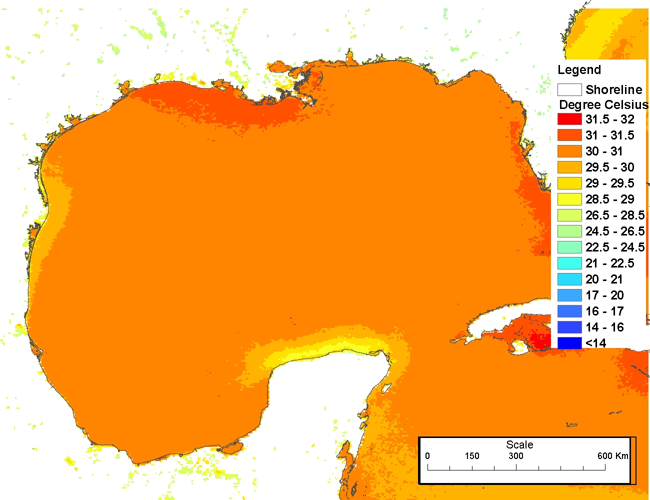
4 km NODC/RSMAS AVHRR Pathfinder Version 5 Seasonal and Annual Day-Night Sea Surface Temperature Climatologies for 1982-2009 for the Gulf of Mexico (NODC Accession 0072888)
The 4 km Pathfinder effort at the National Oceanic and Atmospheric Administration (NOAA) National Oceanographic Data Center (NODC) and the University of Miami's Rosenstiel School of Marine and Atmospheric Science (RSMAS) is an extension of and improvement...
Principal Components Analysis (PCA) Image used to characterize the complexity of the seafloor around St. John, USVI
Eight complexity surfaces (mean depth, standard deviation of depth, curvature, plan curvature, profile curvature, rugosity, slope, and slope of slope) were stacked and exported to create one image with several different bands (each band representing a spe...
Resilience Indicator Summaries and Resilience Scores CNMI Layer Package
ArcGIS layer package of relative classifications (low to high) for six resilience indicators and two anthropogenic stressors and a map of final relative resilience scores for 78 sites in the Commonwealth of the Northern Mariana Islands. The six resilience...
 Eco-spatial data layers of coral reef ecosystem drivers in American Samoa
 This interactive map displays American Samoa data collected by the NOAA Coral Reef Ecosystem Division (CRED) during the Pacific Reef Assessment and Monitoring Program (RAMP) cruises. The information presented is a combination of standard CRED monitoring s...
 Initiate development of LBSP GIS web-layers
 The 4 km Pathfinder effort at the National Oceanic and Atmospheric Administration (NOAA) National Oceanographic Data Center (NODC) and the University of Miami's Rosenstiel School of Marine and Atmospheric Science (RSMAS) is an extension of and improvement...