
High Resolution Aerial Photography of Puerto Rico and the U.S. Virgin Islands, 1965-1999
Aerial photographs were acquired for the Puerto Rico and U.S. Virgin Islands Benthic Mapping Project in 1999 by NOAA Aircraft Operation Centers aircraft and National Geodetic Survey cameras and personnel. Approximately 600, color, 9 by 9 inch photos were ...
High Resolution Aerial Photography of the Main Eight Hawaiian Islands, 2000
Aerial photographs were acquired for the Main Eight Hawaiian Islands Benthic Mapping Project in 2000 by NOAA Aircraft Operation Centers aircraft and National Geodetic Survey cameras and personnel. Approximately 1,500, color, 9 by 9 inch photos were taken ...
NCCOS Assessment: Underwater Video and Photographs for Ground Validation and Accuracy Assessment of Benthic Habitat Maps of Saipan Lagoon, Commonwealth of the Northern Mariana Islands, 2016-07-28 to 2016-08-09
Underwater video and photographs were acquired between 28 July 2016 and 9 August 2016 at nearly 600 sites throughout the lagoon to document the presence and percent-cover of benthic substrate and cover types. Two sets of independent data were collected, o...
NCCOS Assessment: Underwater Video for Ground Validation and Accuracy Assessment of Benthic Habitat Maps of the Insular Shelf South of St. Thomas and St. John, U.S. Virgin Islands, 2010-03-20 to 2017-02-10
The presence and absence of the four substrate and four biological cover types were documented at 1,353 locations on the insular shelf south of St. Thomas and St. John. At each location, an underwater camera system was used to collect high definition (HD)...
NCCOS National Status and Trends Special Study: Assessing Land Based Sources of Pollution in Tinian, Commonwealth of the Northern Mariana Islands, from 2013-08-27 to 2013-08-30
This tabular dataset is the result of field sampling of coral tissues (Pocillopora damicornis) and subsequent laboratory chemical analysis for pollutant levels. The pollutants analyzed included trace elements (Al, Ar, Cd, Cr, Cu, Fe, Pb, Mn, Hg, Ni, Se, A...
Oceanographic data collected during the Deep Water Corals of the Davidson Seamount 2006 expedition aboard the R/V WESTERN FLYER in the North Pacific from January 26, 2006 - February 4, 2006 (NCEI Accession 0052881)
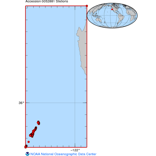
Building off the successes of an Office of Ocean Exploration (OE) expedition to Davidson Seamount in 2002, this project will focus on deep-water corals. The week-long expedition in 2002 was the initial effort to characterize the biology and geology of the...
Oceanographic data collected during the Davidson Seamount 2002 expedition on the RV Western Flyer, in the North Pacific Ocean, southwest of Monterey, California from May 17, 2002 - May 24, 2002 (NCEI Accession 0072306)
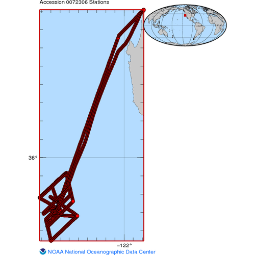
This spring, scientists explored the first "undersea island" to be called a seamount. Davidson seamount, located 120 km Southwest of Monterey, California, is one of the largest known seamounts in U.S. waters. Although these geological features have been k...
Temperature, salinity, and chlorophyll data collected aboard the RV F.G WALTON SMITH in the Florida Keys National Marine Sanctuary, Gulf of Mexico, and North Atlantic Ocean from 01/29/1998 to 08/09/2012 (NCEI Accession 0092099)
A Sea-Bird Electronics Conductivity, Temperature, Depth (CTD) instrument and a Sea-Bird Electronics Thermosalinograph (TSG) flow-through system were utilized during cruises conducted between January 1998 and August 2012 in South Florida coastal waters. Th...