Ground Truth Data Used to Map the Benthic Habitats of Puerto Rico
This project is a cooperative effort among the National Ocean Service, National Centers for Coastal Ocean Science, Center for Coastal Monitoring and Assessment; U.S. Geological Survey; National Park Service; and the National Geophysical Data Center, to pr...
Ground Truth Data Used to Map the Benthic Habitat of the U.S. Virgin Islands
This project is a cooperative effort among the National Ocean Service, National Centers for Coastal Ocean Science, Center for Coastal Monitoring and Assessment; U.S. Geological Survey; National Park Service; and the National Geophysical Data Center to pro...
IKONOS Imagery for American Samoa Utilized to Map Benthic Habitats
This project is a cooperative effort among the National Ocean Service, National Centers for Coastal Ocean Science, Center for Coastal Monitoring and Assessment; the University of Hawaii; and Analytical Laboratories of Hawaii, LLC. IKONOS imagery was purc...
IKONOS Imagery for southern Florida used to map shallow-water seafloor habitats
This project is a cooperative effort between the Florida Fish and Wildlife Conservation Commission, Florida Department of Environmental Protection, National Park Service, U.S. Geological Survey, NOVA Southeastern University, the University of Miami, and t...
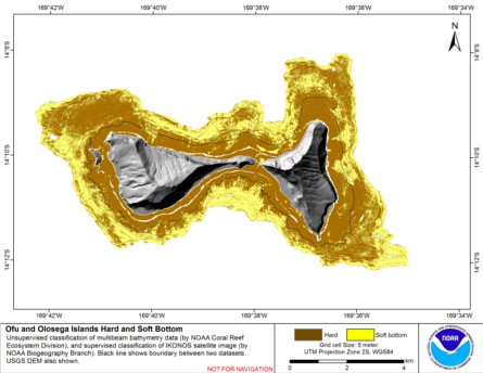
Integrated hard and soft bottom seafloor substrate map of Ofu-Olosega, American Samoa, combining
NOAA Pacific Island Fisheries Science Center Coral Reef Ecosystem Division
hard-soft substrate map with NOAA Center for Coastal Monitoring and Assessment
Biogeography Program shallow-water benthic habitat
map of American Samoa.
Hard and soft seafloor substrate map, derived from integrating
two existing map products: hard and soft seafloor substrate map
derived from an unsupervised classification of multibeam backscatter and
bathymetry derivatives, produced by NOAA Pacific Island...
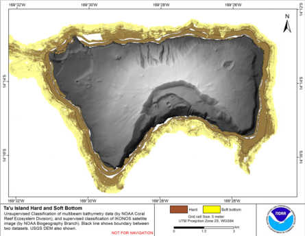
Integrated hard and soft bottom seafloor substrate map of Ta'u, American Samoa, combining
NOAA Pacific Island Fisheries Science Center Coral Reef Ecosystem Division
hard-soft substrate map with NOAA Center for Coastal Monitoring and Assessment
Biogeography Program shallow-water benthic habitat
map of American Samoa.
Hard and soft seafloor substrate map, derived from integrating
two existing map products: hard and soft seafloor substrate map
derived from an unsupervised classification of multibeam backscatter and
bathymetry derivatives, produced by NOAA Pacific Island...
2001-2003 IKONOS Imagery for Guam and the Commonwealth of the Northern Mariana Islands (CNMI) Utilized to Map Shallow Water Benthic Habitats
This project is a cooperative effort among the National Ocean Service, National Centers for Coastal Ocean Science, Center for Coastal Monitoring and Assessment; the University of Hawaii; and Analytical Laboratories of Hawaii, LLC. IKONOS imagery was purc...
 Ground Truth Data Used to Map the Benthic Habitats of Puerto Rico
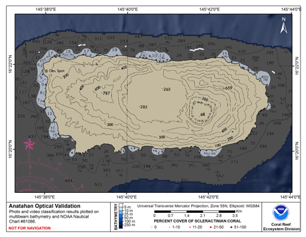 This map displays optical validation observation locations and percent coverage of scleractinian coral overlaid on bathymetry.
 Hard and soft seafloor substrate map, derived from integrating
two existing map products: hard and soft seafloor substrate map
derived from an unsupervised classification of multibeam backscatter and
bathymetry derivatives, produced by NOAA Pacific Island...
Hard and soft seafloor substrate map, derived from integrating
two existing map products: hard and soft seafloor substrate map
derived from an unsupervised classification of multibeam backscatter and
bathymetry derivatives, produced by NOAA Pacific Island...
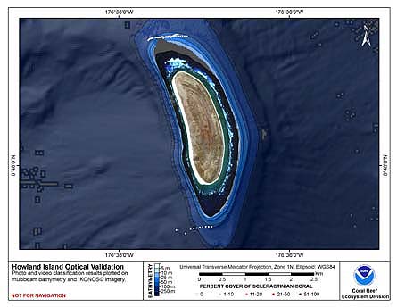
 This map displays optical validation observation locations and percent coverage of scleractinian coral
overlaid on bathymetry.
This map displays optical validation observation locations and percent coverage of scleractinian coral
overlaid on bathymetry.
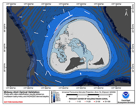
 This map displays optical validation observation locations and percent coverage of scleractinian coral overlaid on bathymetry.