 2010 C-CAP 30 Meter Land Cover of Puerto Rico
This data set consists of land cover derived from high resolution imagery and was analyzed according to the Coastal Change Analysis Program (C-CAP) protocol to determine land cover. This data set utilized 2010 CIR imagery provided by the United Stated Arm...
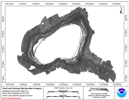 Multibeam backscatter imagery extracted from gridded
bathymetry of Pearl and Hermes Atoll, Northwestern Hawaiian
Islands, USA.
These data provide coverage between 0 and 2000 meters. The
backscatter dataset includes data collected using the Simrad
EM300 mu...
Multibeam backscatter imagery extracted from gridded
bathymetry of Pearl and Hermes Atoll, Northwestern Hawaiian
Islands, USA.
These data provide coverage between 0 and 2000 meters. The
backscatter dataset includes data collected using the Simrad
EM300 mu...
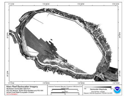 Multibeam backscatter imagery extracted from gridded bathymetry of Maro Reef, Northwestern Hawaiian Islands, USA.
These data provide coverage between 20 and 5000 meters. The backscatter dataset includes data collected using Simrad EM300, Simrad EM3002d,
S...
Multibeam backscatter imagery extracted from gridded bathymetry of Maro Reef, Northwestern Hawaiian Islands, USA.
These data provide coverage between 20 and 5000 meters. The backscatter dataset includes data collected using Simrad EM300, Simrad EM3002d,
S...