Hydroacoustic Biomass Assessment of Reef Fish Spawning Aggregations in Western Puerto Rico (CRCP ID# 1242-05/06/07).
The data set consists of two products. The first product are maps that represent fish average densities collected by active hydroacoustic survey technique in the water column along a transect for each monthly sample. These data are also compiled by loca...
Seafloor substrate (hard and soft bottom) maps at select islands/atolls in American Samoa, Mariana Archipelago, and the Pacific Remote Island Areas
Seafloor substrate (i.e., hard vs. soft bottom) from 0 to up to 50 m depths around islands/atolls in American Samoa, Mariana Archipelago, and Pacific Remote Island Areas produced by the NOAA Ecosystem Sciences Division (ESD). The islands/atolls include Tu...
NCCOS spatial modeling of threatened Caribbean corals: presence-only modeling for threatened Orbicella species from the nearshore to the mesophotic from 2007-01-01 to 2018-12-31 (NCEI Accession 0241110)
This dataset is a compilation of modeled spatial distributions of Threatened corals, Orbicella annularis (lobed star coral) and Orbicella faveolata (mountainous star coral)/Orbicella franksi (boulder star coral). in the shallow and upper mesophotic waters...
NCCOS Assessment: Underwater Video for Ground Validation and Accuracy Assessment of Benthic Habitat Maps of the Insular Shelf South of St. Thomas and St. John, U.S. Virgin Islands, 2010-03-20 to 2017-02-10
The presence and absence of the four substrate and four biological cover types were documented at 1,353 locations on the insular shelf south of St. Thomas and St. John. At each location, an underwater camera system was used to collect high definition (HD)...
CRED Optical Validation Data at Howland Island in the Pacific Remote Islands Area (PRIA), 2002, to Support Benthic Habitat Mapping
Optical validation data were collected using a Tethered Optical Assessment Device (TOAD), an underwater
sled equipped with an underwater digital video camera and lights. Data were collected at Howland Island to support
Benthic Habitat Mapping efforts duri...
The design of this field mission is three fold: (1) to spatially characterize the distribution, abundance and size of both reef fishes and macro invertebrates within and around the waters of the Flower Gardens National Marine Sanctuary using, (2) to relat...
CRED Optical Validation Data at French Frigate Shoals to Support Benthic Habitat Mapping, 2001, to Support Benthic Habitat Mapping
Optical validation data were collected using a Tethered Optical Assessment Device (TOAD), an underwater
sled equipped with an underwater digital video camera and lights. Data were collected at the Northwestern Hawaiian
Islands, French Frigate Shoals to su...
CRED Optical Validation Data at Baker Island in the Pacific Remote Islands Area (PRIA), 2002, to Support Benthic Habitat Mapping
Optical validation data were collected using a Tethered Optical Assessment Device (TOAD), an underwater
sled equipped with an underwater digital video camera and lights. Data were collected at Baker Island to support
Benthic Habitat Mapping efforts during...
CRED Optical Validation Data at Palmyra Atoll in the Pacific Remote Islands Area (PRIA), 2002
to support Benthic Habitat Mapping
Optical validation data were collected using a Tethered Optical Assessment Device (TOAD), an underwater sled
equipped with an underwater digital video camera and lights. Data were collected at Palmyra Atoll to support Benthic
Habitat Mapping efforts durin...
 Hydroacoustic Biomass Assessment of Reef Fish Spawning Aggregations in Western Puerto Rico (CRCP ID# 1242-05/06/07).
 Seafloor substrate (hard and soft bottom) maps at select islands/atolls in American Samoa, Mariana Archipelago, and the Pacific Remote Island Areas
 Seafloor substrate (i.e., hard vs. soft bottom) from 0 to up to 50 m depths around islands/atolls in American Samoa, Mariana Archipelago, and Pacific Remote Island Areas produced by the NOAA Ecosystem Sciences Division (ESD). The islands/atolls include Tu...
 Broward County benthic habitat maps
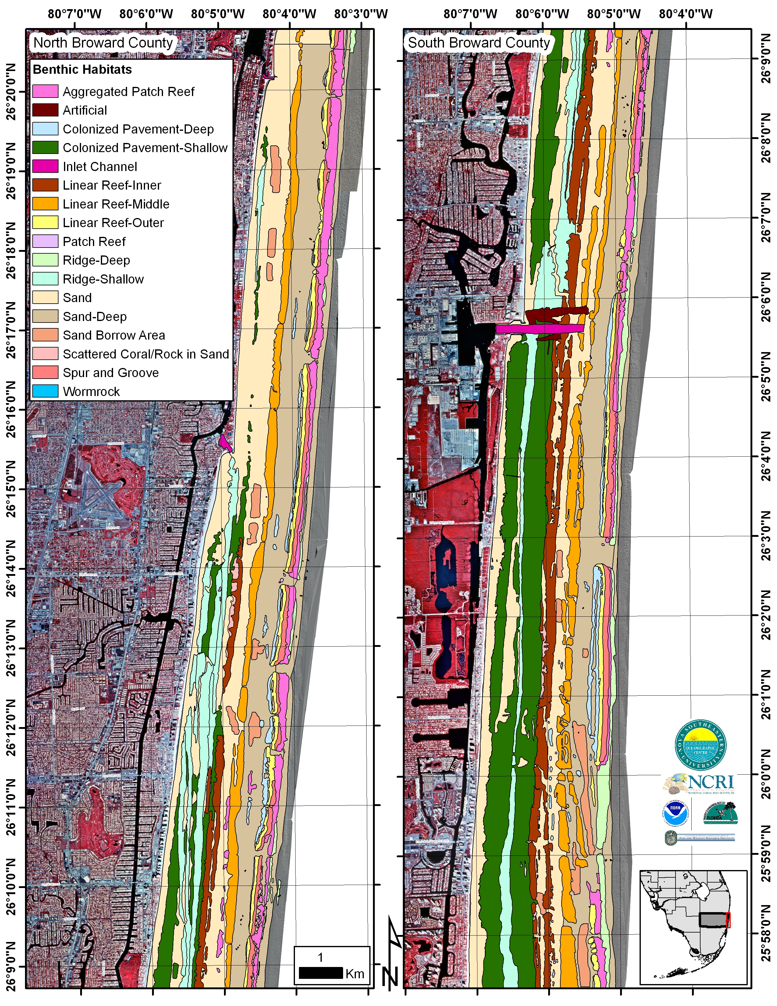 "Benthic habitat maps of north and south Broward County, southeastern Florida."