4 km AVHRR Pathfinder v5.0 Global Day-Night Sea Surface Temperature Averages, 1985-2009 (NODC Accession 0077816)
This data set contains a set of monthly and yearly global day-night sea surface temperature averages, derived from the AVHRR Pathfinder Version 5 sea surface temperature cloudscreened data set (http://pathfinder.nodc.noaa.gov) in GeoTIFF format. The AVHRR...
The Coastal Use Mapping Project is designed to collect critical information on human activities in and near the St. Thomas East End Reserves (STEER). The project purpose is to improve understanding of the spatial range and intensity of key human activitie...
Water temperature data from reef sites off the upper Florida Keys from 2003-09-18 to 2022-12-11 (NCEI Accession 0126994)
Temperature loggers were deployed at various monitoring sites off the upper Florida Keys where other ecological studies were underway, most focused on aspects of Acropora spp. status or ecology. Hobo Tidbit® or Pendant® loggers were secured to the substra...
Coral and artificial reef shape files, Broward County, Florida, (NODC Accession 0000244)
Coral reef and artificial reef location shape files and accompanying table files for reefs located off shore of Broward County, Florida. Accompanying "attribute" tables provide information on artificial reef type, date of creation, and associated informa...
NCCOS mapping: seafloor mapping products for the Florida Keys National Marine Sanctuary from 2004-01-01 to 2019-09-22 (NCEI Accession 0170215)
This dataset is an inventory of seafloor mapping data from hydrographic multibeam sonar surveys and georeferenced benthic photographs and video clips, all collected in and around the Florida Keys National Marine Sanctuary (FKNMS). The multibeam data sets ...
The National Oceanographic and Atmospheric Administration's (NOAA) Undersea Research
Center at the University of North Carolina at Wilmington (NURC/UNCW) coordinated an acoustic
survey in portions of the Oculina Habitat Area of Particular Concern from Jun...
This document briefly describes the user interface and funtionality of the PORT (Parameterized Online Reporting Tool) now available on the AGRRA website. Through this tool users may select from any of the basic report types and then customize the output b...
Oculina Banks Habitat Area of Particular Concern Geographic Information System 2002 (NODC Accession 0090252)
OGIS provides a comprehensive, interactive data source for the Oculina Banks Habitat Area of Particular Concern (OHAPC),
a marine protected area off the east coast of Florida in 70 to 120 meters of water depth. An Oculina Geographic
Information System (OG...
The Hawaii Coastal Use Mapping Project is an innovative partnership between NOAA's National Marine Protected Areas Center, NOAA's Pacific Islands Fisheries Science Center, NOAA's Pacific Islands Regional Office, and the Hawaii Division of Aquatic Resource...
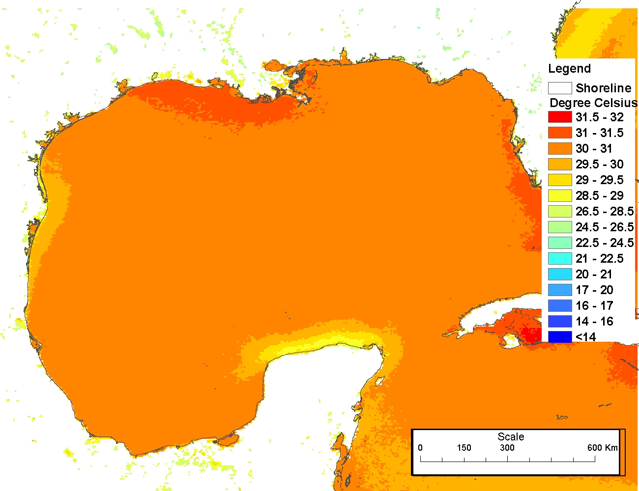
4 km NODC/RSMAS AVHRR Pathfinder Version 5 Seasonal and Annual Day-Night Sea Surface Temperature Climatologies for 1982-2009 for the Gulf of Mexico (NODC Accession 0072888)
The 4 km Pathfinder effort at the National Oceanic and Atmospheric Administration (NOAA) National Oceanographic Data Center (NODC) and the University of Miami's Rosenstiel School of Marine and Atmospheric Science (RSMAS) is an extension of and improvement...
 4 km AVHRR Pathfinder v5.0 Global Day-Night Sea Surface Temperature Averages, 1985-2009 (NODC Accession 0077816)
 This data set contains a set of monthly and yearly global day-night sea surface temperature averages, derived from the AVHRR Pathfinder Version 5 sea surface temperature cloudscreened data set (http://pathfinder.nodc.noaa.gov) in GeoTIFF format. The AVHRR...
 AGRRA-PORT Atlantic and Gulf Rapid Reef Assessment Parameterized Online Reporting Tool
 The 4 km Pathfinder effort at the National Oceanic and Atmospheric Administration (NOAA) National Oceanographic Data Center (NODC) and the University of Miami's Rosenstiel School of Marine and Atmospheric Science (RSMAS) is an extension of and improvement...