Palmyra Atoll, 2006 Sea Surface Temperature and Meteorological Enhanced Mooring - CRED CREWS Near Real Time and Historical Data
Site Palmyra Atoll, (5.88467, -162.10281 ) ARGOS ID 307-001. Time series data from this mooring provide high resolution sea surface temperature and conductivity, and surface atmospheric pressure, air temperature, compass, surface PAR, salinity, surface ...
Saipan 2005 Sea Surface Temperature and Meteorological Enhanced Mooring - CRED CREWS Near Real Time and Historical Data
Site Saipan, CNMI (15.2375N, 145.72283W) ARGOS Buoy ID 26105
Time series data from this mooring provide high resolution sea surface temperature, and surface atmospheric pressure, air temperature, compass, surface PAR, conductivity, surface UVB, subsurface...
Rose Island, American Samoa, 2006 Sea Surface Temperature and Meterological Standard Mooring - CRED CREWS Near Real Time and Historical Data
Site - Rose Island, American Samoa, -14.5514, -168.16018 ARGOS ID 27267
Time series data from this mooring provide high resolution sea surface temperature, surface atmospheric pressure, air temperature, compass, direction component wind velocity U/V; fo...
French Frigate Shoals, NWHI, 2005 Sea Surface Temperature and Meteorological Enhanced (Iridium) Mooring - CRED CREWS Near Real Time and Historical Data
Site - French Frigate Shoals, NWHI (23.85678, -166.27183 ) ARGOS ID 261-003
Time series data from this mooring provide high resolution sea surface temperature, and surface atmospheric pressure, air temperature, compass, surface PAR, salinity, surface U...
Kure Atoll, NWHI, 2004 Sea Surface Temperature and
Meterological Standard Mooring - CRED CREWS Near Real Time and
Historical Data
Site - Kure Atoll, NW Hawaiian Islands (28.41858, -178.34333 )
ARGOS ID 21392 Time series data from this mooring provide high
resolution sea surface temperature, surface atmospheric pressure, air
temperature, compass, direction components of wind velocity...
Maro Reef, NWHI 2004 Sea Surface Temperature and Meterological Standard Mooring - CRED CREWS Near Real Time and Historical Data
Site - Maro Reef, NW Hawaiian Islands (25.44643, -170.63366 ) ARGOS ID 21531
Time series data from this mooring provide high resolution sea surface temperature, surface atmospheric pressure, air temperature, compass, direction components of wind velocity...
Pearl and Hermes, NWHI, 2004 Sea Surface Temperature and Meterological Standard Mooring - CRED CREWS Near Real Time and Historical Data
Site - Pearl and Hermes, NW Hawaiian Islands 27.85N, 175.82W, ARGOS ID 21376
Time series data from this mooring provide high resolution sea surface temperature, surface atmospheric pressure, air temperature, compass, direction component wind velocity U...
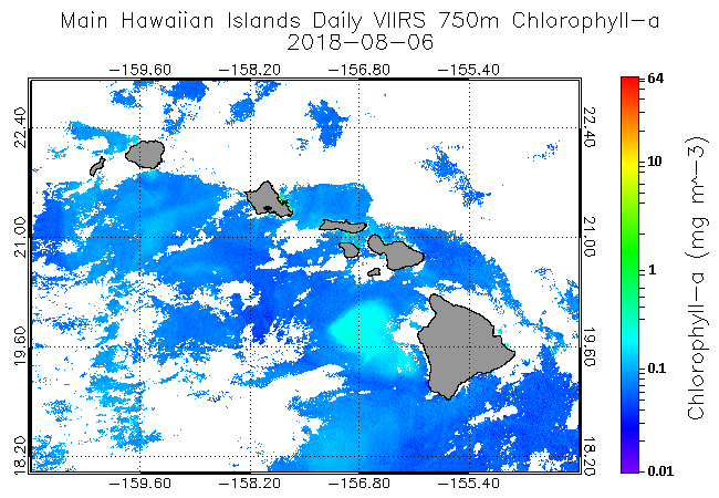
NOAA Coral Reef Watch Experimental Daily 750m VIIRS Satellite Ocean Color Monitoring for the Main Hawaiian Islands
NOAA Coral Reef Watch (CRW) and the NOAA/National Environmental Satellite, Data, and Information Service (NESDIS)/Center for Satellite Applications and Research (STAR) Ocean Color Team are working closely with partners in the U.S. Coral Reef Task Force (U...
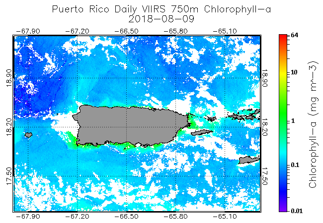
NOAA Coral Reef Watch Experimental Daily 750m VIIRS Satellite Ocean Color Monitoring for Puerto Rico
NOAA Coral Reef Watch (CRW) and the NOAA/National Environmental Satellite, Data, and Information Service (NESDIS)/Center for Satellite Applications and Research (STAR) Ocean Color Team are working closely with partners in the U.S. Coral Reef Task Force (U...
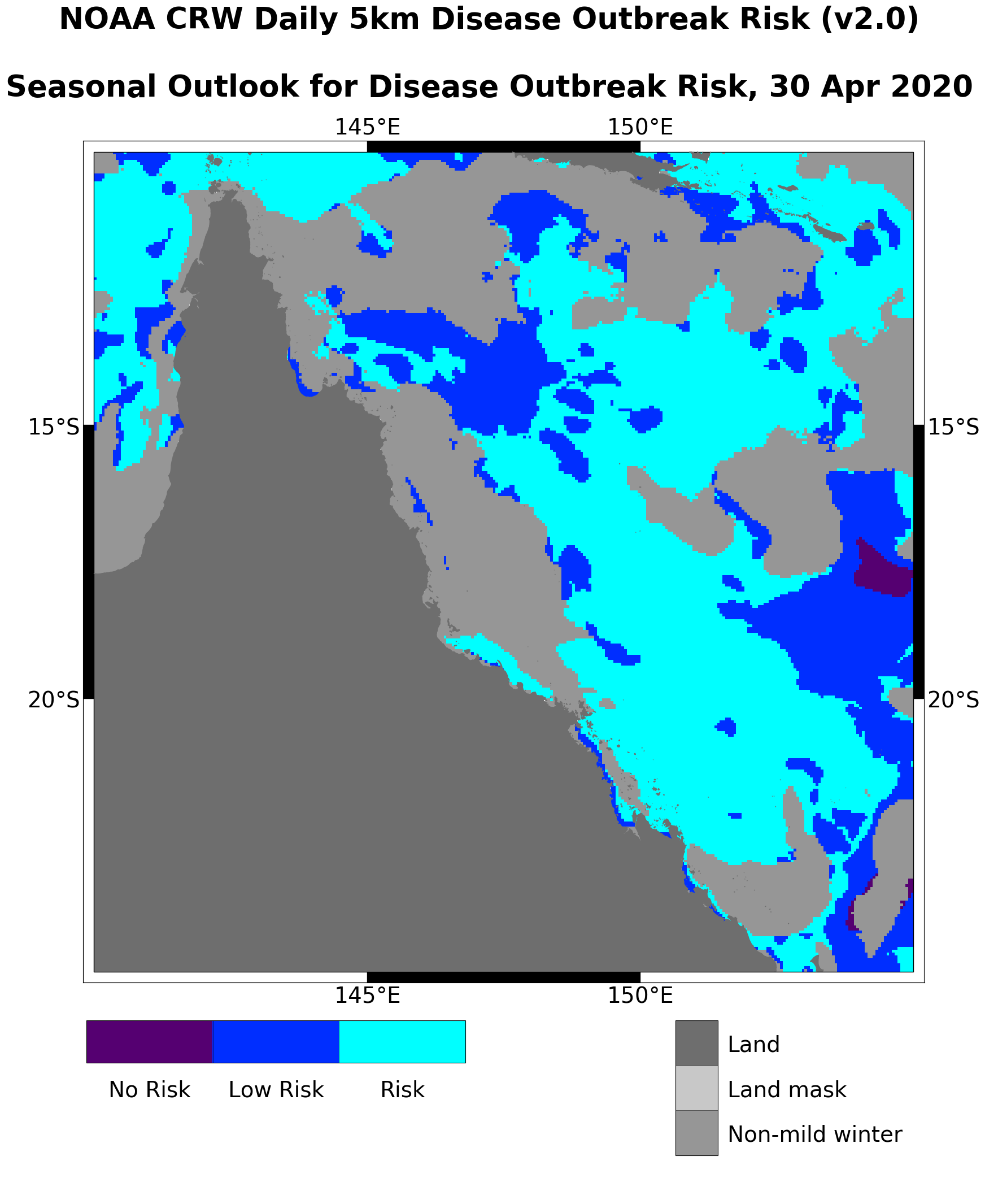
NOAA Coral Reef Watch 5km Regional Satellite Coral Disease Outbreak Risk Monitoring Products - Great Barrier Reef, Australia
The NOAA Coral Reef Watch (CRW) 5km-resolution Regional Satellite Coral Disease Outbreak Risk Monitoring Products estimate the potential for infectious disease outbreak in the upcoming summer season for select coral reef regions; i.e., the Great Barrier R...
 Palmyra Atoll, 2006 Sea Surface Temperature and Meteorological Enhanced Mooring - CRED CREWS Near Real Time and Historical Data
 NOAA Coral Reef Watch Experimental Daily 750m VIIRS Satellite Ocean Color Monitoring for the Main Hawaiian Islands
 NOAA Coral Reef Watch (CRW) and the NOAA/National Environmental Satellite, Data, and Information Service (NESDIS)/Center for Satellite Applications and Research (STAR) Ocean Color Team are working closely with partners in the U.S. Coral Reef Task Force (U...
 NOAA Coral Reef Watch (CRW) and the NOAA/National Environmental Satellite, Data, and Information Service (NESDIS)/Center for Satellite Applications and Research (STAR) Ocean Color Team are working closely with partners in the U.S. Coral Reef Task Force (U...
 The NOAA Coral Reef Watch (CRW) 5km-resolution Regional Satellite Coral Disease Outbreak Risk Monitoring Products estimate the potential for infectious disease outbreak in the upcoming summer season for select coral reef regions; i.e., the Great Barrier R...