PIRO Fishery Biologist with local agency partners from Guam Environmental Protection Agency and University of Guam Marine Laboratory gathered photographic and GPS data to document impacts to the reef and evaluate removal methods.
Assessment of Take Maru Grounding, Cocos Lagoon, Guam. 2014.
PIRO Fishery Biologist with local agency partners from Guam Environmental Protection Agency and Guam Department of Agriculture gathered photographic and GPS data to document impacts to the reef and evaluate removal methods.
CRED Benthic Habitat Towboard Still Photos from Jarvis Island in March and April, 2004
This data is in the form of JPEG still photos taken every 15 seconds from a benthic habitat towboard being towed by small boats at Jarvis Island between March 26 and April 5, 2004. The towboard is operated by a SCUBA diver who maintains the camera approxi...
CRED Benthic Habitat Towboard Still Photos from Kingman Atoll in March and April, 2004
This data is in the form of JPEG still photos taken every 15 seconds from a benthic habitat towboard being towed by small boats at Kingman Island between March 26 and April 5, 2004. The towboard is operated by a SCUBA diver who maintains the camera approx...
CRED Benthic Habitat Towboard Still Photos from Palmyra in March and April, 2004
This data is in the form of JPEG still photos taken every 15 seconds from a benthic habitat towboard being towed by small boats at Palmyra Atoll between March 26 and April 5, 2004. The towboard is operated by a SCUBA diver who maintains the camera approxi...
NOAA Coral Reef Watch Twice-weekly Global 50km Satellite Coral Bleaching Heat Stress Data and Products
The NOAA Coral Reef Watch (CRW) heritage near real-time twice-weekly global 50km satellite coral bleaching heat stress monitoring products were operational at NOAA until April 30, 2020, when they were officially retired, and succeeded by CRW's next-genera...
Abundance and behavior of parrotfishes (Labridae, Scarinae) in the upper Florida Keys (NODC Accession 0127525)
To better understand the functional roles of parrotfishes on Caribbean reefs we documented abundance, habitat preferences, and diets of nine species of parrotfishes (Scarus coelestinus, Scarus coeruleus, Scarus guacamaia, Scarus taeniopterus, Scarus vetul...
"In this newsletter, you will find stories about NOAA collaborating on citizen science at Stellwagen, ecological forecasting, and regional collaboration activities planned for FY15."
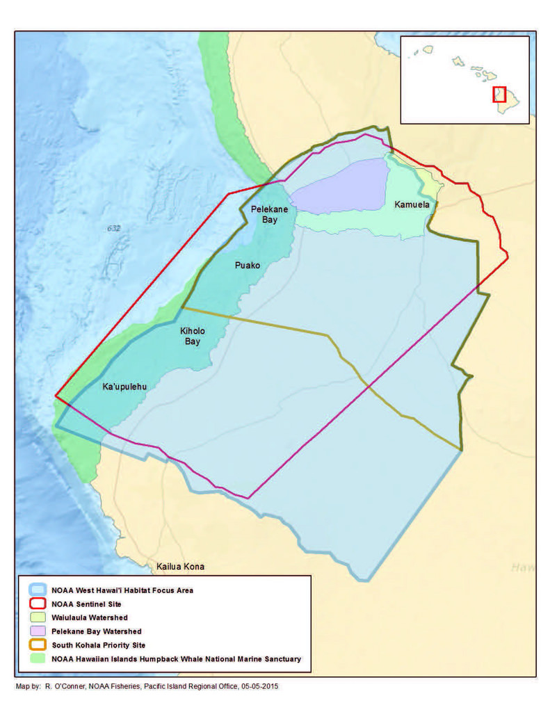
Hard and Soft Bottom Seafloor Substrate Map Derived from an Unsupervised Classification of Gridded Bathymetry Derivatives for the NOAA Habitat Blueprint West Hawaii Focus Area
Hard and soft bottom seafloor substrate data and maps for the NOAA Habitat Blueprint West Hawaii Focus Area (WHFA) in the Main Hawaiian Islands. Cell values in the raster datasets reflect whether the seafloor is hard bottom or soft bottom based on an unsu...
Dominant Benthic Structure and Biological Cover Habitat Maps for West Maui and West Hawaii
Benthic habitat maps depict dominant substrate type and biological cover in depths between 0 and ~150 m for two priority sites in the Main Hawaiian Islands; the NOAA Habitat Blueprint West Hawaii Focus Area (WHFA) and the Hawaii Division of Aquatic Resour...
 Assessment of Daiki Maru Grounding, Spanish Steps, Orote Peninsula, Outer Apra Harbor, Guam. 2014.
 This data is in the form of JPEG still photos taken every 15 seconds from a benthic habitat towboard being towed by small boats at Jarvis Island between March 26 and April 5, 2004. The towboard is operated by a SCUBA diver who maintains the camera approxi...
 NOAA Coral Reef Watch Twice-weekly Global 50km Satellite Coral Bleaching Heat Stress Data and Products
 News from NOAA in the North Atlantic, Fall 2014
 Hard and soft bottom seafloor substrate data and maps for the NOAA Habitat Blueprint West Hawaii Focus Area (WHFA) in the Main Hawaiian Islands. Cell values in the raster datasets reflect whether the seafloor is hard bottom or soft bottom based on an unsu...