 Ground Truth Data Used to Map the Benthic Habitat of the U.S. Virgin Islands
This project is a cooperative effort among the National Ocean Service, National Centers for Coastal Ocean Science, Center for Coastal Monitoring and Assessment; U.S. Geological Survey; National Park Service; and the National Geophysical Data Center to pro...
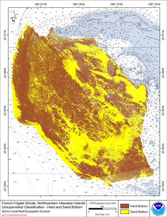 Preliminary hard and soft seafloor substrate map derived
from an unsupervised classification of multibeam backscatter and
bathymety derivatives at French Frigate Shoals, Northwestern
Hawaiian Islands, USA. The dataset was derived using a
combination of Si...
Preliminary hard and soft seafloor substrate map derived
from an unsupervised classification of multibeam backscatter and
bathymety derivatives at French Frigate Shoals, Northwestern
Hawaiian Islands, USA. The dataset was derived using a
combination of Si...
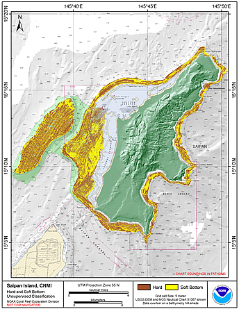 Preliminary hard and soft seafloor substrate map derived
from an unsupervised classification of multibeam backscatter and
bathymety derivatives at Saipan Island, Commonwealth of the Northern
Mariana Islands (CNMI). The dataset was derived using Reson
8101...
Preliminary hard and soft seafloor substrate map derived
from an unsupervised classification of multibeam backscatter and
bathymety derivatives at Saipan Island, Commonwealth of the Northern
Mariana Islands (CNMI). The dataset was derived using Reson
8101...
 Preliminary hard and soft seafloor substrate map derived
from an unsupervised classification of multibeam backscatter and
bathymety derivatives at Tutuila Island, American Samoa, South
Pacific. The dataset was derived using a combination of Simrad
em3002d...
Preliminary hard and soft seafloor substrate map derived
from an unsupervised classification of multibeam backscatter and
bathymety derivatives at Tutuila Island, American Samoa, South
Pacific. The dataset was derived using a combination of Simrad
em3002d...
 This data set (Project Number OPR-I305-KRL-06) depicts depth values (mean 5 meter gridded) collected using LiDAR
(Light Detection & Ranging) from the shoreline of southwestern Puerto Rico to the shelf edge. The Tenix LADS Corporation
(TLI) acquired bathym...
This data set (Project Number OPR-I305-KRL-06) depicts depth values (mean 5 meter gridded) collected using LiDAR
(Light Detection & Ranging) from the shoreline of southwestern Puerto Rico to the shelf edge. The Tenix LADS Corporation
(TLI) acquired bathym...
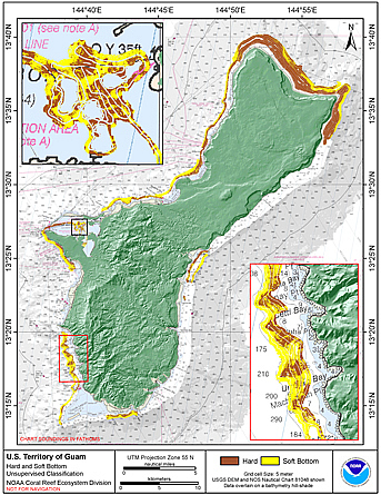 Preliminary hard and soft seafloor substrate map derived
from an unsupervised classification of multibeam backscatter and
bathymety derivatives at the U.S. Territory of Guam. The
dataset was derived using Reson 8101 backscatter data, bathymetric
variance ...
Preliminary hard and soft seafloor substrate map derived
from an unsupervised classification of multibeam backscatter and
bathymety derivatives at the U.S. Territory of Guam. The
dataset was derived using Reson 8101 backscatter data, bathymetric
variance ...
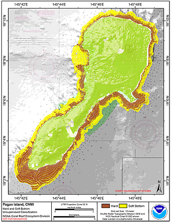 Preliminary hard and soft seafloor substrate map derived
from an unsupervised classification of multibeam backscatter and
bathymety derivatives at Pagan Island, Commonwealth of the
Northern Mariana Islands (CNMI). The dataset was derived using Reson
8101 ...
Preliminary hard and soft seafloor substrate map derived
from an unsupervised classification of multibeam backscatter and
bathymety derivatives at Pagan Island, Commonwealth of the
Northern Mariana Islands (CNMI). The dataset was derived using Reson
8101 ...
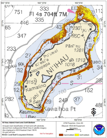 Preliminary hard and soft seafloor substrate map derived
from an unsupervised classification of multibeam backscatter and
bathymety derivatives of Ni'ihau Island, Hawaii, USA . The
dataset was derived using Reson 8101 backscatter data, bath...
Preliminary hard and soft seafloor substrate map derived
from an unsupervised classification of multibeam backscatter and
bathymety derivatives of Ni'ihau Island, Hawaii, USA . The
dataset was derived using Reson 8101 backscatter data, bath...
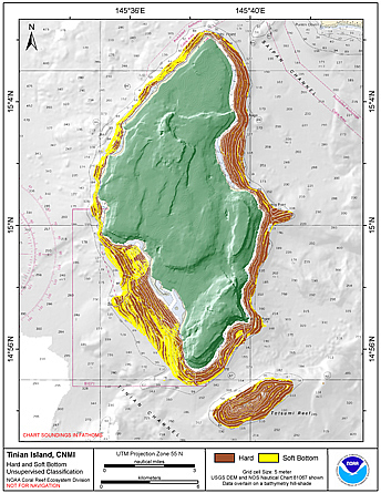 Preliminary hard and soft seafloor substrate map derived
from an unsupervised classification of multibeam backscatter and
bathymety derivatives at Tinian Islands and Tatsumi
Bank, CNMI. The dataset was derived using Reson 8101 backscatter data,
bathymetri...
Preliminary hard and soft seafloor substrate map derived
from an unsupervised classification of multibeam backscatter and
bathymety derivatives at Tinian Islands and Tatsumi
Bank, CNMI. The dataset was derived using Reson 8101 backscatter data,
bathymetri...
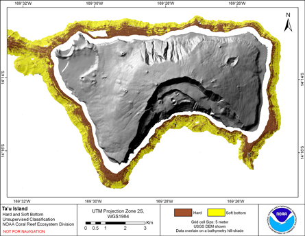 Preliminary hard and soft seafloor substrate map derived
from an unsupervised classification of multibeam backscatter and
bathymety derivatives at Ta'u Island, Territory of American Samoa, USA . The
dataset was derived using Reson 8101 backscatter data, b...
Preliminary hard and soft seafloor substrate map derived
from an unsupervised classification of multibeam backscatter and
bathymety derivatives at Ta'u Island, Territory of American Samoa, USA . The
dataset was derived using Reson 8101 backscatter data, b...