Estimated Depth Maps of the Northwestern Hawaiian Islands Derived from High Resolution IKONOS Satellite Imagery (Draft)
Estimated shallow-water, depth maps were produced using rule-based, semi-automated image analysis of high-resolution satellite imagery for nine locations in the Northwestern Hawaiian Islands. This project is a cooperative effort between the National Ocean...
Fishery Ecosystem Plan for the Pacific Remote Island Areas
This Pacific Remote Island Areas Fishery Ecosystem Plan (FEP) was developed by the Western Pacific Regional Fishery Management Council and represents the first step in an incremental and collaborative approach to implement ecosystem approaches to fishery ...
FBSAD Recruit Reef Fish Belt Transect Survey at Hawaii Island (Big Island), Main Hawaiian Islands, 2005 (NODC Accession 0046935)
Shore-based belt transects were conducted at 8-13 m depths at 3 longshore sites on the leeward coast (North and South Kohala districts) of the Big Island (Hawaii Island) in the MHI during spring 2005. From 8-10 randomly positioned transects were surveyed ...
FBSAD Reef Fish-Habitat Quadrat Surveys at Hawaii Island (Big Island), Main Hawaiian Islands, 2005 (NODC Accession 0046935)
Habitat quadrats were surveyed at 8-13 m depths using shore-based transects swum at 3 longshore sites on the leeward coast (North and South Kohala districts) of the Big Island (Hawaii Island, in the MHI) during spring 2005. Substratum percent cover and ru...
FBSAD RECRUIT Reef Fish Belt Transect Survey at Hawaii Island (Big Island), Main Hawaiian Islands, 2008; and Midway Atoll, Northwestern Hawaiian Islands (NWHI), 2008 (NODC Accession 0067519)
Shore-based belt transects were conducted at 1 to ~ 5 m depths at a total four (4) sites: at (1-2) 2 longshore sites on the leeward coast (South Kohala district) of the Big Island (Hawaii Island) in the MHI during spring-summer 2008; and (3-4) at 2 longsh...
FBSAD PREDATOR Reef Fish Belt Transect Survey at Hawaii Island (Big Island), Main Hawaiian Islands, 2008; and Midway Atoll, Northwestern Hawaiian Islands (NWHI), 2008 (NODC Accession 0067519)
Shore-based belt transects were conducted at 1 to ~5 m depths at a total four (4) sites: at (1-2) 2 longshore sites on the leeward coast (South Kohala district) of the Big Island (Hawaii Island) in the MHI during spring-summer 2008; and (3-4) 2 longshore ...
 Estimated Depth Maps of the Northwestern Hawaiian Islands Derived from High Resolution IKONOS Satellite Imagery (Draft)
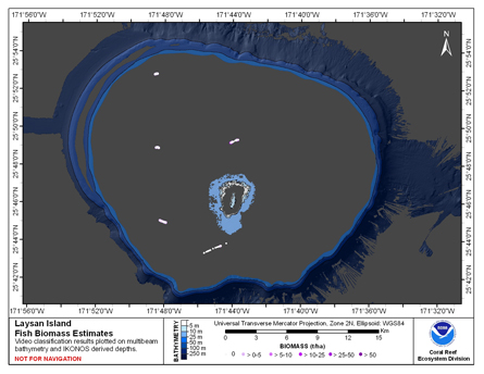 This map displays fish biomass observation locations overlaid on bathymetry
 Fishery Ecosystem Plan for the Pacific Remote Island Areas
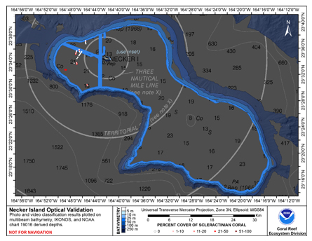 This map displays optical validation observation locations and percent coverage of scleractinian coral overlaid on bathymetry.
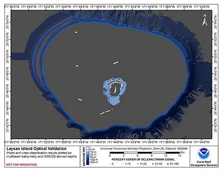 This map displays optical validation observation locations and percent coverage of scleractinian coral overlaid on bathymetry.
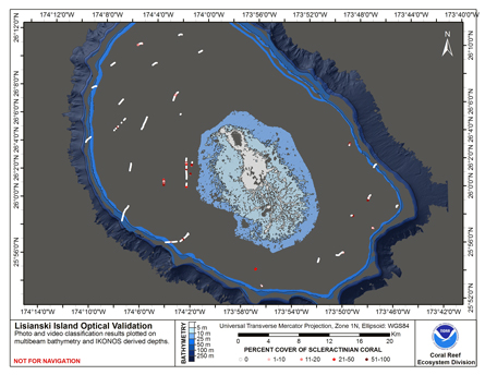 This map displays optical validation observation locations and percent coverage of scleractinian coral overlaid on bathymetry.