Benthic habitat maps of the nearshore marine environment of Majuro, Republic of the Marshall Islands were created by visual interpretation of remotely sensed imagery. The objective of this effort, conducted by NOAA's Center for Coastal Monitoring and Asse...
Atlas of the shallow-water benthic habitats of Majuro Atoll, Republic of the Marshall Islands
Digital maps of the shallow (<~30m deep) coral reef ecosystems of Majuro Atoll, Republic of the Marshall Islands, were created through visual interpretation of remote sensing imagery acquired between 2004 and 2006. Reef ecosystem features were digitized d...
Majuro Atoll, Republic of the Marshall Islands coral reef ecosystems mapping report
Digital maps of the coral reef ecosystem (<~30m deep) of Majuro Atoll, Republic of the Marshall Islands, were created through visual interpretation of remote sensing imagery. Digital Globe's Quickbird II satellite images were acquired between 2004 and 200...
Endangered Species and Wildlife Resources Inventory Kwajalein Atoll, U.S. Army , Republic of the Marshall Islands 1996 (NODC Accession 0000251)
This report summarizes the results of the first Environmental Standards and Procedures (UES) inventory of endangered species and wildlife resources at United States Army Kwajalein Atoll (USAKA), which was conducted in 1996. The primary objective of the in...
SEM-Pasifika Workshop report, Republic of the Marshall Islands May 4-9, 2008
From May 4-9, a SEM-Pasifika training program began in Majuro, Republic of the Marshall Islands. Seventeen trainees were present from around the region including American Samoa, Hawaii, Kosrae, Pohnpei, Chuuk, Commonwealth of the Northern Mariana Islands,...
1998 Inventory of Endangered Species and Wildlife Resources at the US Army Kwajalein Atoll, Republic of the Marshall Islands (NODC Accession 0000631)
This report summarizes the results of the second United States Army Kwajalein Atoll (USAKA) Activities in the Republic of the Marshall Islands (UES) inventory of endangered species and wildlife resources at USAKA, which was conducted in 1998. The first wa...
Shallow-water (<30m) benthic habitat maps of the nearshore marine environment of Jobos Bay, Puerto Rico were mapped and characterized using visual interpretation of optical and acoustic remotely sensed imagery. The objective of this effort, conducted by N...
Shallow-Water Benthic Habitats of Southwest Puerto Rico: Accuracy Assessment Site Locations
Shallow-water (<30m) benthic habitat maps of the nearshore marine environment of two areas in Southwest Puerto Rico (PR), including the Guanica Bay/La Parguera region on the south coast and the Belvedere reserve on the west coast, were mapped and charact...
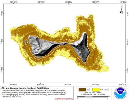
Integrated hard and soft bottom seafloor substrate map of Ofu-Olosega, American Samoa, combining
NOAA Pacific Island Fisheries Science Center Coral Reef Ecosystem Division
hard-soft substrate map with NOAA Center for Coastal Monitoring and Assessment
Biogeography Program shallow-water benthic habitat
map of American Samoa.
Hard and soft seafloor substrate map, derived from integrating
two existing map products: hard and soft seafloor substrate map
derived from an unsupervised classification of multibeam backscatter and
bathymetry derivatives, produced by NOAA Pacific Island...
"The Majuro, Marshall Islands BIOMapper, is a fully interactive, online feature designed to let users explore benthic habitat mapping data. This portal contains a comprehensive collection of data, including satellite imagery, benthic habitat shapefiles, g...
 Majuro_Benthic_Habitats
 Atlas of the shallow-water benthic habitats of Majuro Atoll, Republic of the Marshall Islands
 Hard and soft seafloor substrate map, derived from integrating
two existing map products: hard and soft seafloor substrate map
derived from an unsupervised classification of multibeam backscatter and
bathymetry derivatives, produced by NOAA Pacific Island...
Hard and soft seafloor substrate map, derived from integrating
two existing map products: hard and soft seafloor substrate map
derived from an unsupervised classification of multibeam backscatter and
bathymetry derivatives, produced by NOAA Pacific Island...