
Waianae Ecological Characterization Oahu, Hawaii 2004
The Waianae Ecological Characterization is a digital synthesis of historical and current physical, ecological, and cultural information about the Waianae moku, which is located on the leeward coast of the Hawaiian Island of Oahu. The characterization emp...
NOAA ESRI Grid Puerto Rico, La Parguera, 2006: 3M Multibeam Bathymetry, Project NF-06-03, UTM 19 NAD83
This dataset contains an ESRI Grid with 3 meter cell size representing the bathymetry of the southwest shore of
La Parguera, Puerto Rico.
NOAA's NOS/NCCOS/CCMA Biogeography Team, in collaboration with NOAA vessel Nancy Foster and territory, federal, and
...
NOS TIFF Image, 3M Backscatter Mosaic La Parguera, Puerto Rico, 2006 : Project NF-06-03, UTM 19 NAD83
This image represents a 3 meter resolution backscatter mosaic of the south west shore (La Parguera) of Puerto Rico.
NOAA's NOS/NCCOS/CCMA Biogeography Team, in collaboration with NOAA vessel Nancy Foster and territory, federal, and
private sector partner...
NOAA ESRI Grid - 3m Bathymetry around Abrir La Sierra Bank, Puerto Rico, Project NF-07-06, 2007, UTM 19 NAD 83
This dataset contains an ESRI Grid with 3 meter cell size representing the bathymetry of selected portions of seafloor around Abrir La Sierra Bank in Puerto Rico, derived from data collected in 2007.
NOAA's NOS/NCCOS/CCMA Biogeography Team, in collaborat...
 Gridded bathymetry and IKONOS estimated depths of the shelf and slope
environments of the Northwestern Hawaiian Islands, USA within UTM Zone 3. Bottom
coverage was achieved in depths between 0 and 5200 meters. The ASCII includes
multibeam bathymetry from ...
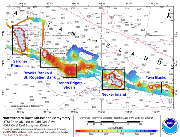
Gridded bathymetry and IKONOS estimated depths of the shelf and slope
environments of the Northwestern Hawaiian Islands, USA within UTM Zone 3. Bottom
coverage was achieved in depths between 0 and 5200 meters. The ASCII includes
multibeam bathymetry from ...
 Gridded bathymetry and IKONOS estimated depths of the shelf and slope
environments of the Northwestern Hawaiian Islands, USA within UTM Zone 2. Bottom
coverage was achieved in depths between 0 and 5000 meters. The netCDF includes
multibeam bathymetry from...
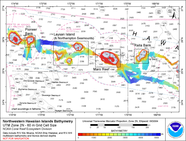
Gridded bathymetry and IKONOS estimated depths of the shelf and slope
environments of the Northwestern Hawaiian Islands, USA within UTM Zone 2. Bottom
coverage was achieved in depths between 0 and 5000 meters. The netCDF includes
multibeam bathymetry from...
 Gridded bathymetry and IKONOS estimated depths of the shelf and slope
environments of the Northwestern Hawaiian Islands, USA within UTM Zone 1. Bottom
coverage was achieved in depths between 0 and 5000 meters. The ASCII includes
multibeam bathymetry from ...
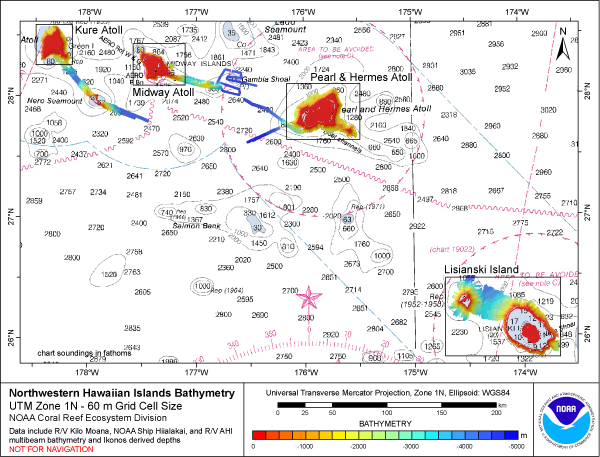
Gridded bathymetry and IKONOS estimated depths of the shelf and slope
environments of the Northwestern Hawaiian Islands, USA within UTM Zone 1. Bottom
coverage was achieved in depths between 0 and 5000 meters. The ASCII includes
multibeam bathymetry from ...