
Waianae Ecological Characterization Oahu, Hawaii 2004
The Waianae Ecological Characterization is a digital synthesis of historical and current physical, ecological, and cultural information about the Waianae moku, which is located on the leeward coast of the Hawaiian Island of Oahu. The characterization emp...

Key Largo Coral Reef National Marine Sanctuary Deep Water Resource Survey
The Key Largo Coral Reef Marine Sanctuary (Sanctuary) extends from the State's territorial sea off Key Largo, Florida, seaward to the 91 meter (300 foot) isobath. It is approximately 32.2 kilometers (20 miles) long, and 8.05 kilometers (5 miles) wide. Abo...
Bathymetry 2M Grid, US Virgin Islands, 2005, UTM 20 NAD83
This dataset contains a unified ESRI Grid with 2 meter cell size representing the bathymetry of selected portions
of seafloor around St. Croix, St. Thomas, and St. John in the US Virgin Islands, derived from data collected in 2005.
NOAA's NOS/NCCOS/CCMA ...
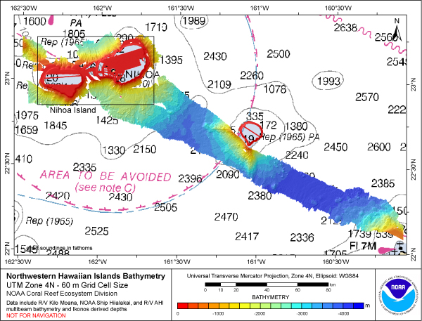 Gridded bathymetry (60m) of the shelf and slope environments of the
Northwestern Hawaiian Islands, USA within UTM Zone 4. Bottom coverage was achieved
in depths between 0 and 5000 meters. The ASCII includes multibeam bathymetry from
the Simrad EM120, EM10...
Gridded bathymetry (60m) of the shelf and slope environments of the
Northwestern Hawaiian Islands, USA within UTM Zone 4. Bottom coverage was achieved
in depths between 0 and 5000 meters. The ASCII includes multibeam bathymetry from
the Simrad EM120, EM10...
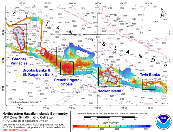 Gridded bathymetry and IKONOS estimated depths of the shelf and slope
environments of the Northwestern Hawaiian Islands, USA within UTM Zone 3. Bottom
coverage was achieved in depths between 0 and 5200 meters. The netCDF includes
multibeam bathymetry from...
Gridded bathymetry and IKONOS estimated depths of the shelf and slope
environments of the Northwestern Hawaiian Islands, USA within UTM Zone 3. Bottom
coverage was achieved in depths between 0 and 5200 meters. The netCDF includes
multibeam bathymetry from...
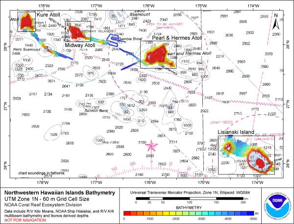 Gridded bathymetry and IKONOS estimated depths of the shelf and slope
environments of the Northwestern Hawaiian Islands, USA within UTM Zone 1. Bottom
coverage was achieved in depths between 0 and 5000 meters. The ASCII includes
multibeam bathymetry from ...
Gridded bathymetry and IKONOS estimated depths of the shelf and slope
environments of the Northwestern Hawaiian Islands, USA within UTM Zone 1. Bottom
coverage was achieved in depths between 0 and 5000 meters. The ASCII includes
multibeam bathymetry from ...
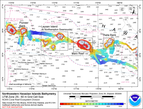 Gridded bathymetry and IKONOS estimated depths of the shelf and slope
environments of the Northwestern Hawaiian Islands, USA within UTM Zone 2. Bottom
coverage was achieved in depths between 0 and 5000 meters. The ASCII includes
multibeam bathymetry from ...
Gridded bathymetry and IKONOS estimated depths of the shelf and slope
environments of the Northwestern Hawaiian Islands, USA within UTM Zone 2. Bottom
coverage was achieved in depths between 0 and 5000 meters. The ASCII includes
multibeam bathymetry from ...