CRED REA Coral Population Parameters at Baker, Pacific Remote Island Areas (PRIAs), 2006
Belt transects along 2 consecutively-placed, 25m transect lines were surveyed as part of Rapid Ecological
Assessments conducted at 9 sites at Baker in the Pacific Remote Island Areas (PRIAs) during 15 January - 6 February 2006
in the NOAA Hi'ialakai Reef ...
Shallow-water Marine Invertebrates French Frigate Shoals, Northwestern Hawaiian Islands 2000 and 2002, (NODC Accession 0001083)
This dataset focuses on marine surveys used to obtain a more in depth record of the marine fauna from French Frigate Shoals and includes
a note on nonindigenous species from NOWRAMP 2000 surveys at 39 sites and a March 2002 survey at a single site.
In Sep...
Recruitment processes influence coral population dynamics as well as reef community structure. Coral recruitment is generally determined by one of three methods: artificial settlement plates, small-scale macro photography, or painstaking visual searches i...
Grain Size Distribution and Fate of Transplanted Corals at Kawaihae, Hawaii: Field work of 1996-1997 (NODC Accession 0001141)
A harbor expansion was planned in the early 1990s for Kawaihae, Hawaii on the northwest shore of the Big Island. To offset the habitat loss, select corals were transplanted. This study looked at the effects of sedimentation on the transplanted and non-tra...
Benthic Macroinvertebrate Community Assessment, Northwestern Hawaiian Islands, October 2000, (NODC Accession 0002301)
The Northwestern Hawaiian lslands were sampled during October 2000 at 63 stations on 9 atolls or
islands under the lead of NOAA. This work is affiliated with the Northwest Hawaii Islands Coral Reef Assessment
and Monitoring Program (NOWRAMP), which perfor...
 CRED REA Coral Population Parameters at Baker, Pacific Remote Island Areas (PRIAs), 2006
 Shallow-water Marine Invertebrates French Frigate Shoals, Northwestern Hawaiian Islands 2000 and 2002, (NODC Accession 0001083)
 Fluorescence census techniques for coral recruits
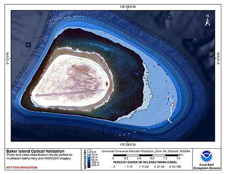 This map displays optical validation observation locations and percent coverage of scleractinian coral overlaid on bathymetry.
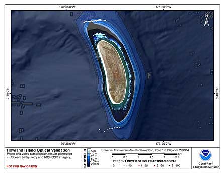
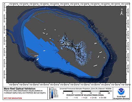
 This map displays optical validation observation locations and percent coverage of scleractinian coral overlaid on bathymetry.
 This map displays optical validation observation locations and percent coverage of scleractinian coral overlaid on bathymetry.
 This map displays optical validation observation locations and percent coverage of scleractinian coral overlaid on bathymetry.
 This map displays optical validation observation locations and percent coverage of scleractinian coral overlaid on bathymetry.