 Mosaic of gridded multibeam bathymetry and bathymetry derived
from multispectral IKONOS satellite imagery of Johnston Atoll,
Pacific Remote Island Area, USA
Mosaic of gridded multibeam bathymetry and bathymetry derived
from multispectral IKONOS satellite imagery of Johnston Atoll,
Pacific Remote Island Area, USA
 Gridded multibeam bathymetry is integrated with bathymetry
derived from multispectral IKONOS satellite data. Gridded (5 m cell
size) multibeam bathymetry collected aboard NOAA Ship Hiialaka'i and
R/V AHI. Bathymetry values shallower than 25 m were derived...
Gridded multibeam bathymetry is integrated with bathymetry
derived from multispectral IKONOS satellite data. Gridded (5 m cell
size) multibeam bathymetry collected aboard NOAA Ship Hiialaka'i and
R/V AHI. Bathymetry values shallower than 25 m were derived...
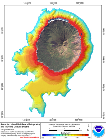
 Gridded multibeam bathymetry is integrated with bathymetry
derived from multpectral IKONOS satellite data. Gridded (5m and 10 m cell
size) multibeam bathymetry collected aboard NOAA Ship Hiialaka'i and
R/V AHI. Bathymetry values shallower than 25 m were d...
Gridded multibeam bathymetry is integrated with bathymetry
derived from multpectral IKONOS satellite data. Gridded (5m and 10 m cell
size) multibeam bathymetry collected aboard NOAA Ship Hiialaka'i and
R/V AHI. Bathymetry values shallower than 25 m were d...
 Gridded multibeam bathymetry is integrated with bathymetry
derived from multispectral IKONOS satellite data. Gridded (5 m cell
size) multibeam bathymetry collected aboard NOAA Ship Hiialaka'i and
R/V AHI. Bathymetry values shallower than 25 m were derived...
Gridded multibeam bathymetry is integrated with bathymetry
derived from multispectral IKONOS satellite data. Gridded (5 m cell
size) multibeam bathymetry collected aboard NOAA Ship Hiialaka'i and
R/V AHI. Bathymetry values shallower than 25 m were derived...
 Gridded multibeam bathymetry is integrated with gridded LiDAR
bathymetry and bathymetry derived from multispectral IKONOS satellite
data. Gridded (5 m cell size) multibeam bathymetry collected aboard NOAA
Ship Hiialaka'i and R/V AHI. LiDAR/multibeam bathy...
Gridded multibeam bathymetry is integrated with gridded LiDAR
bathymetry and bathymetry derived from multispectral IKONOS satellite
data. Gridded (5 m cell size) multibeam bathymetry collected aboard NOAA
Ship Hiialaka'i and R/V AHI. LiDAR/multibeam bathy...
 Gridded multibeam bathymetry is integrated with bathymetry derived
from multispectral IKONOS satellite data. Gridded (5 m cell size) multibeam
bathymetry collected aboard NOAA Ship Hiialaka'i and R/V AHI. Bathymetry values
shallower than 25 m were derived...
Gridded multibeam bathymetry is integrated with bathymetry derived
from multispectral IKONOS satellite data. Gridded (5 m cell size) multibeam
bathymetry collected aboard NOAA Ship Hiialaka'i and R/V AHI. Bathymetry values
shallower than 25 m were derived...
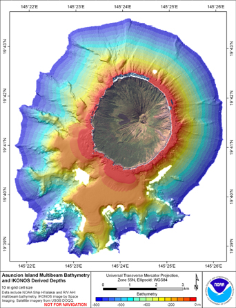
 Gridded multibeam bathymetry is integrated with bathymetry derived
from multispectral IKONOS satellite data. Gridded (10 m cell size) multibeam
bathymetry collected aboard NOAA Ship Hiialaka'i and R/V AHI. Bathymetry values
shallower than 25 m were derive...
Gridded multibeam bathymetry is integrated with bathymetry derived
from multispectral IKONOS satellite data. Gridded (10 m cell size) multibeam
bathymetry collected aboard NOAA Ship Hiialaka'i and R/V AHI. Bathymetry values
shallower than 25 m were derive...
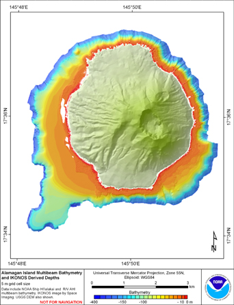
 Gridded multibeam bathymetry is integrated with bathymetry
derived from multpectral IKONOS satellite data. Gridded (5 m cell
size) multibeam bathymetry collected aboard NOAA Ship Hiialaka'i and
R/V AHI. Bathymetry values shallower than 15 m were derived b...
Gridded multibeam bathymetry is integrated with bathymetry
derived from multpectral IKONOS satellite data. Gridded (5 m cell
size) multibeam bathymetry collected aboard NOAA Ship Hiialaka'i and
R/V AHI. Bathymetry values shallower than 15 m were derived b...
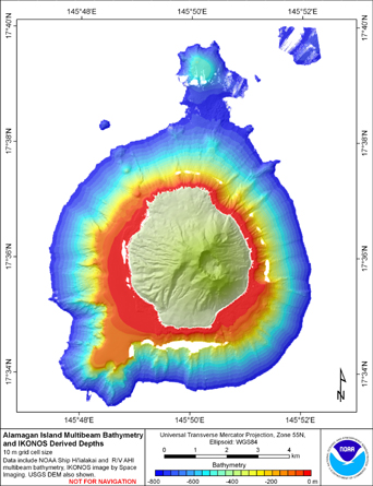
 Gridded multibeam bathymetry is integrated with bathymetry
derived from multpectral IKONOS satellite data. Gridded (10 m cell
size) multibeam bathymetry collected aboard NOAA Ship Hiialaka'i and
R/V AHI. Bathymetry values shallower than 15 m were derived ...
Gridded multibeam bathymetry is integrated with bathymetry
derived from multpectral IKONOS satellite data. Gridded (10 m cell
size) multibeam bathymetry collected aboard NOAA Ship Hiialaka'i and
R/V AHI. Bathymetry values shallower than 15 m were derived ...