 Faga'alu watershed PLA resource map
This map was generated from the PLA Watershed Workshop for Faga'alu Village using the resource mapping tool.
Faga'alu watershed PLA resource map
Baseline surveys of proposed and established marine sanctuaries on Bantayan Island, Northern Cebu
 "A total of nine declared and proposed Marine Sanctuaries were visited by researchers from University of Guam Marine Lab from June 13 to 17, 2011, with assistance from managers from the Batas Kalikasan Foundation. The purpose of this work was to perform b...
 American Samoa Watershed and Coastal Community Data Layers, Utulei, Fagaalu, Fatumafuti 2014
Deep-Sea Coral Research and Technology Program: Alaska Deep-Sea Coral and Sponge Initiative Final Report
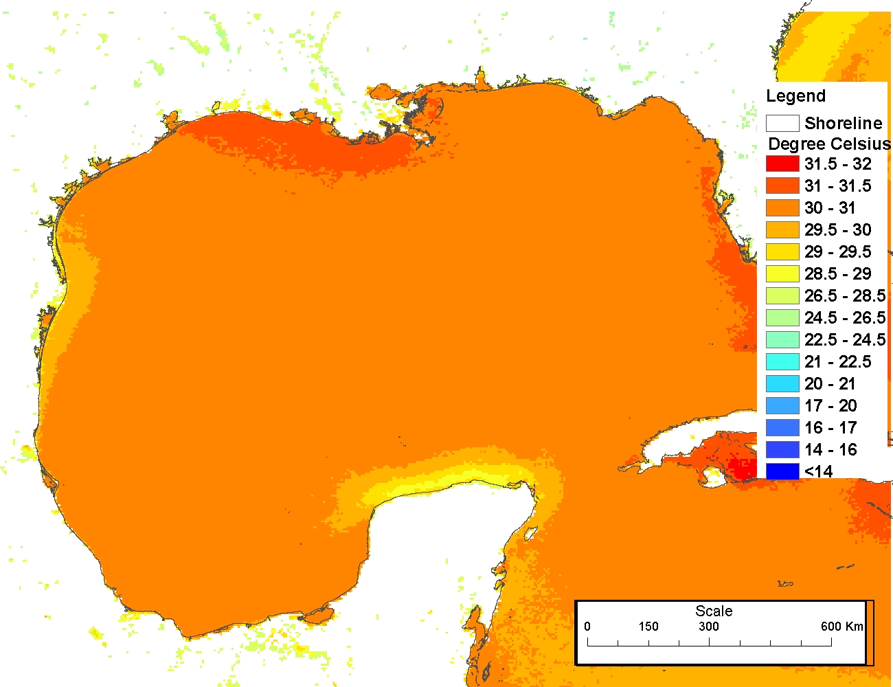
4 km NODC/RSMAS AVHRR Pathfinder v5.0 and Interim v5.0 Sea Surface Temperature (SST) Data and v5.1 SST Data for 1981-2009
American Samoa Watershed and Coastal Community Data Layers, Utulei, Fagaalu, Fatumafuti 2014
Deep-Sea Coral Research and Technology Program: Alaska Deep-Sea Coral and Sponge Initiative Final Report
4 km NODC/RSMAS AVHRR Pathfinder v5.0 and Interim v5.0 Sea Surface Temperature (SST) Data and v5.1 SST Data for 1981-2009
 The 4 km Pathfinder effort at the National Oceanic and Atmospheric Administration (NOAA) National Oceanographic Data Center (NODC) and the University of Miami's Rosenstiel School of Marine and Atmospheric Science (RSMAS) is an extension of and improvement...
4 km NODC/RSMAS AVHRR Pathfinder Version 5 Seasonal and Annual Day-Night Sea Surface Temperature Climatologies for 1982-2009 for the Gulf of Mexico (NODC Accession 0072888)
The 4 km Pathfinder effort at the National Oceanic and Atmospheric Administration (NOAA) National Oceanographic Data Center (NODC) and the University of Miami's Rosenstiel School of Marine and Atmospheric Science (RSMAS) is an extension of and improvement...
4 km NODC/RSMAS AVHRR Pathfinder Version 5 Seasonal and Annual Day-Night Sea Surface Temperature Climatologies for 1982-2009 for the Gulf of Mexico (NODC Accession 0072888)
 The 4 km Pathfinder effort at the National Oceanic and Atmospheric Administration (NOAA) National Oceanographic Data Center (NODC) and the University of Miami's Rosenstiel School of Marine and Atmospheric Science (RSMAS) is an extension of and improvement...
4 km NODC/RSMAS AVHRR Pathfinder v.5.0 Sea Surface Temperature (SST) Climatologies (1985-2001)
The Coral Reef Temperature Anomaly Database (CoRTAD) Version 2 - Global, 4 km Sea Surface Temperature and Related Thermal Stress Metrics for 1982-2008 (NODC Accession Number 0054501)
The 4 km Pathfinder effort at the National Oceanic and Atmospheric Administration (NOAA) National Oceanographic Data Center (NODC) and the University of Miami's Rosenstiel School of Marine and Atmospheric Science (RSMAS) is an extension of and improvement...
4 km NODC/RSMAS AVHRR Pathfinder v.5.0 Sea Surface Temperature (SST) Climatologies (1985-2001)
The Coral Reef Temperature Anomaly Database (CoRTAD) Version 2 - Global, 4 km Sea Surface Temperature and Related Thermal Stress Metrics for 1982-2008 (NODC Accession Number 0054501)
 The Coral Reef Temperature Anomaly Database (CoRTAD) is a collection of sea surface temperature (SST) and related thermal stress metrics, developed specifically for coral reef ecosystem applications but relevant to other ecosystems as well. The CoRTAD Ve...
The Coral Reef Temperature Anomaly Database (CoRTAD) Version 3 - Global, 4 km
Sea Surface Temperature and Related Thermal Stress Metrics for 1982-2009 (NODC
Accession 0068999)
The Coral Reef Temperature Anomaly Database (CoRTAD) is a collection of sea
surface temperature (SST) and related thermal stress metrics, developed specifically
for coral reef ecosystem applications but relevant to other ec...
NOAA/WDS Paleoclimatology - Palmyra Island Coral 110 Year Sr/Ca SST and d18Osw
The Coral Reef Temperature Anomaly Database (CoRTAD) is a collection of sea surface temperature (SST) and related thermal stress metrics, developed specifically for coral reef ecosystem applications but relevant to other ecosystems as well. The CoRTAD Ve...
The Coral Reef Temperature Anomaly Database (CoRTAD) Version 3 - Global, 4 km
Sea Surface Temperature and Related Thermal Stress Metrics for 1982-2009 (NODC
Accession 0068999)
The Coral Reef Temperature Anomaly Database (CoRTAD) is a collection of sea
surface temperature (SST) and related thermal stress metrics, developed specifically
for coral reef ecosystem applications but relevant to other ec...
NOAA/WDS Paleoclimatology - Palmyra Island Coral 110 Year Sr/Ca SST and d18Osw
 This Paleoclimatology Study is archived at and available from the NOAA National Centers for Environmental Information (NCEI), under the World Data Service (WDS) for Paleoclimatology. The NOAA Paleoclimatology Study Type is Coral. The data include paramete...