Coral cover remains suppressed three years after derelict net removal in a remote shallow water coral reef ecosystem
The uninhabited Northwestern Hawaiian Islands (NWHI) contain 70 % of the shallow water coral reefs in the United States. An estimated 52 metric tons of derelict fishing nets accumulate here annually, becoming entangled in the reef structure and reducing c...
Nearshore bathymetry gap filling around the Island of Oahu, Hawaii
The NOAA Pacific Islands Fisheries Science Center's Coral Reef Ecosystem Division Mapping Program conducted 13 days of acoustic benthic habitat mapping operations aboard the R/V AHI around the island of Oahu, Hawaii. Survey operations extended from Pearl ...
Comparing Coral Colony Surveys From In-Water Observations and Structure-From-Motion Imagery Shows Low Methodological Bias
As the threats to coral reefs mount, scientists and managers are looking for innovative ways to increase the scope, scale, and efficiency of coral reef monitoring. Monitoring changes in coral communities and demographic features provides key information a...
Linking Watershed Activities to Reef Health in American Samoa: Land-Based Sources of Pollution Impacts on Aua Coral Reefs
"The overarching goals of this project were to establish a water quality and biological baseline for reefs in Aua, American Samoa, and provide managers with recommendations on how to reduce land-based sources of pollution (LBSP) in order to protect their ...
Comparing Coral Demographic Surveys From In Situ Observations and Structure-From-Motion Photogrammetry on High Diversity Reefs Shows Low Methodological Bias but Highlights Persistent Areas of Concern
The Pacific Islands Fisheries Science Center’s Ecosystem Sciences Division (ESD) executes the National Coral Reef Monitoring Program (NCRMP) across 40 primary islands, atolls, and shallow banks in the U.S. Pacific. The goal of NCRMP is to understand how r...
Comparing coral demographic surveys from in situ observations and Structure-from-Motion imagery shows low methodological bias
NOAA’s Ecosystem Sciences Division (ESD) at the Pacific Islands Fisheries Science Center (PIFSC) executes the NOAA Coral Reef Conservation Program’s National Coral Reef Monitoring Program (NCRMP) across 40 primary islands, atolls, and shallow banks in the...
Sampling grids to support the collection and analysis of survey data for the National Coral Reef Monitoring Program in American Samoa, Pacific Remote Islands Areas, Main Hawaiian Islands
The sampling grids are identified as essential components for the stratified random sampling design of the National Coral Reef Monitoring Program (NCRMP). The benthic habitat map layers including bathymetry, hard and soft substrates, reef zones and sector...
Gridded bathymetry shelf, bank and slope environments of
Ni'ihau Island. This 5 m grid contains data between 0 and 100 meters.
The netCDF and Arc ASCII grids include multibeam
bathymetry from the Simrad EM300 and Reson 8101 multibeam sonars
collected as o...
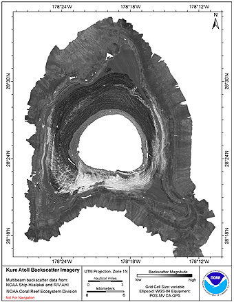
CRED Simrad EM3002d multibeam backscatter data from portions of
the banktop and bank edge environments at Kure Atoll, Hawaii, USA with 1
meter resolution
Multibeam backscatter imagery extracted from gridded
bathymetry of Kure Atoll, Northwestern Hawaiian Islands, USA.
These data provide coverage between 0 and 2000 meters. The
backscatter dataset includes data collected using the Simrad
EM3002d multibeam so...
CRED Reson 8101 multibeam backscatter data from the islands and banks in the Mariana archipelago, 2007.
Multibeam backscatter imagery extracted from gridded
bathymetry of the Mariana archipelago between the U.S. Territory
of Guam and Uracas Island in the Commonwealth of the Northern
Mariana Islands. These data provide coverage between 0 and -300
meters. The...
 Coral cover remains suppressed three years after derelict net removal in a remote shallow water coral reef ecosystem
 Sampling grids to support the collection and analysis of survey data for the National Coral Reef Monitoring Program in American Samoa, Pacific Remote Islands Areas, Main Hawaiian Islands
 Gridded bathymetry shelf, bank and slope environments of
Ni'ihau Island. This 5 m grid contains data between 0 and 100 meters.
The netCDF and Arc ASCII grids include multibeam
bathymetry from the Simrad EM300 and Reson 8101 multibeam sonars
collected as o...
Gridded bathymetry shelf, bank and slope environments of
Ni'ihau Island. This 5 m grid contains data between 0 and 100 meters.
The netCDF and Arc ASCII grids include multibeam
bathymetry from the Simrad EM300 and Reson 8101 multibeam sonars
collected as o...
 Multibeam backscatter imagery extracted from gridded
bathymetry of Kure Atoll, Northwestern Hawaiian Islands, USA.
These data provide coverage between 0 and 2000 meters. The
backscatter dataset includes data collected using the Simrad
EM3002d multibeam so...
Multibeam backscatter imagery extracted from gridded
bathymetry of Kure Atoll, Northwestern Hawaiian Islands, USA.
These data provide coverage between 0 and 2000 meters. The
backscatter dataset includes data collected using the Simrad
EM3002d multibeam so...
 Multibeam backscatter imagery extracted from gridded
bathymetry of the Mariana archipelago between the U.S. Territory
of Guam and Uracas Island in the Commonwealth of the Northern
Mariana Islands. These data provide coverage between 0 and -300
meters. The...
Multibeam backscatter imagery extracted from gridded
bathymetry of the Mariana archipelago between the U.S. Territory
of Guam and Uracas Island in the Commonwealth of the Northern
Mariana Islands. These data provide coverage between 0 and -300
meters. The...