Assessment of fish populations and habitat on Oculina Bank, a deep-sea coral marine protected area off eastern Florida
"A portion of the Oculina Bank located off eastern Florida is a marine protected area (MPA) preserved for its dense populations of the ivory tree coral (Oculina varicosa), which provides important habitat for fish. Surveys of fish assemblages and benthic ...
Survey of coral and fish assemblages on Pulley Ridge, SW Florida a report to the Gulf of Mexico Fishery Management Council
The coral reef community covering Pulley Ridge is the deepest known light-dependent coral reef on the US continental shelf. Located off the southwest coast of Florida, the ridge is a drowned barrier island colonized by several species of hermatypic coral ...
November 2007 Multibeam Mapping of South West corner of Pulley Ridge
This disk or set of disks contain high-resolution multibeam and backscatter maps
of the south-western corner of the Pulley Ridge Area, near the Tortugas, in the Gulf of Mexico.
It includes the following products: 1) *.ASC File of the area mapped, 2) Caris...
2006 Multibeam Mapping of along-shelf corridor, between Madison-Swanson and Steamboat Lumps Florida
This disk or set of disks contain high-resolution multibeam and backscatter maps
of a long thin corridor at the shelf edge near he 74-m isobath spanning from Madison-Swanson
(29.1667N, 85.6667W) in the north to Steamboat (28.1667N, 84.6667W), in West-Flor...
2006 Multibeam Mapping of cross-shelf corridor, North of Madison-Swanson - Florida
This disk or set of disks contain high-resolution multibeam and backscatter maps
of an area North of Madison-Swanson (29.1667N, 85.6667W), in the West-Florida shelf,
not included in a previous mapping expedition to the area. It includes the following pro...
February 2007 Multibeam Mapping of Pulley Ridge, southwest Florida
This disk or set of disks contain high-resolution multibeam and backscatter maps
of the Pulley Ridge Area, near the Tortugas, in the Gulf of Mexico.
It includes the following products: 1) Text file containing X, Y, Z postprocessed bathymetry data,
2) Text...
Factors contributing to the regional decline of Montastraea annularis (complex)
"Over the last 15 years the massive framework coral, Montastraea annularis (complex) has experienced a rapid decline in abundance, size and condition, and on many reefs in the western Atlantic these species are no longer the dominant corals. Surveys condu...
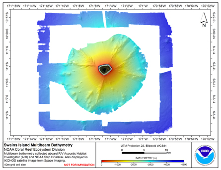
40 m Gridded bathymetry of Swains Island, American Samoa (netCDF format)
Gridded bathymetry (40 m cell size) of the slope environment
of Swains Island, American Samoa. Almost complete bottom coverage was
achieved in depths between 7 and 4800 m. The multibeam data are from
the Simrad EM300 system aboard the NOAA Ship Hi'ialakai...
 Assessment of fish populations and habitat on Oculina Bank, a deep-sea coral marine protected area off eastern Florida
 November 2007 Multibeam Mapping of South West corner of Pulley Ridge
 February 2007 Multibeam Mapping of Pulley Ridge, southwest Florida
 Gridded bathymetry (40 m cell size) of the slope environment
of Swains Island, American Samoa. Almost complete bottom coverage was
achieved in depths between 7 and 4800 m. The multibeam data are from
the Simrad EM300 system aboard the NOAA Ship Hi'ialakai...
Gridded bathymetry (40 m cell size) of the slope environment
of Swains Island, American Samoa. Almost complete bottom coverage was
achieved in depths between 7 and 4800 m. The multibeam data are from
the Simrad EM300 system aboard the NOAA Ship Hi'ialakai...