
Sea surface temperatures from AVHRR
The production of these AVHRR L2P data is a NEODAAS activity in collaboration with the UK National Centre for Ocean Forecasting (NCOF). NEODAAS-Dundee acquires approx. 15 AVHRR HRPT passes per day over NW Europe and Arctic, each approx. 15 minutes duratio...
Earth observation based assessment of anthropogenic stress to coral reefs - a global analysis
"In this paper a remote sensing based approach to assess potential anthropogenic stress to coral reefs worldwide is presented. Three reef stressors are analyzed using nighttime lights data derived from the Defense Meteorological Satellite Program (DMSP) p...

Benthic, urchin, and fish observation data collected using multiple methodologies to calculate coral reef carbonate budget estimates for sites off of O'ahu in the Main Hawaiian Islands in 2021 (NCEI Accession 0283630)
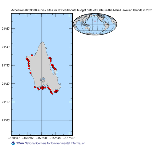
This data package includes the benthic, urchin, and fish observation data collected for coral reef carbonate budget assessments by the Ecosystem Sciences Division (ESD) of NOAA's Pacific Island Fisheries Science Center (PIFSC) at fixed sites around O'ahu ...
Benthic, urchin, and fish observation data collected using multiple methodologies to calculate coral reef carbonate budget estimates for sites in the Mariana Archipelago in 2022 (NCEI Accession 0283896)
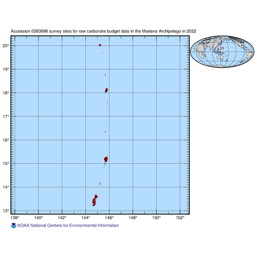
This data package includes the benthic, urchin, and fish observation data collected for coral reef carbonate budget assessments by the Ecosystem Sciences Division (ESD) of NOAA's Pacific Island Fisheries Science Center (PIFSC) at fixed sites across the Ma...
Landsat 7 ETM/1G satellite imagery - Hawaiian Islands cloud-free mosaics
Cloud-free Landsat satellite imagery mosaics of the islands of the main 8 Hawaiian Islands (Hawaii, Maui, Kahoolawe, Lanai, Molokai, Oahu, Kauai and Niihau). Landsat 7 ETM (enhanced thematic mapper) is a polar orbiting 8 band
multispectral satellite-borne...
Principal Components Analysis (PCA) Image used to characterize the complexity of the seafloor around St. John, USVI
Eight complexity surfaces (mean depth, standard deviation of depth, curvature, plan curvature, profile curvature, rugosity, slope, and slope of slope) were stacked and exported to create one image with several different bands (each band representing a spe...
Water depth and acoustic backscatter data collected from NOAA Ship Nancy Foster in Caribbean Sea, from 2015-03-18 to 2015-04-07 (NCEI Accession 0131859)
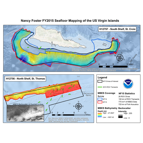
NOAA's NOS/NCCOS/CCMA Biogeography Team, in collaboration with NOAA vessel NOAA Ship Nancy Foster and territory, federal, and private sector partners, conducted the twelfth year of an ongoing scientific research mission onboard NOAA Ship Nancy Foster, fun...
2012 NOAA American Samoa Lidar DEM: Islands of Tutuila, Aunu'u, Ofu, Olosega, Ta'u and Rose Atoll

Light Detection and Ranging (LiDAR) data is remotely sensed high-resolution elevation data collected by an airborne collection
platform. This LiDAR dataset is a survey of American Samoa including the islands of Tutuila, Aunu'u, Ofu, Olosega, Ta'u and Rose...
2012 NOAA American Samoa Lidar: Islands of Tutuila, Aunu'u, Ofu, Olosega, Ta'u and Rose Atoll
Light Detection and Ranging (LiDAR) data is remotely sensed high-resolution elevation data collected by an airborne collection
platform. This LiDAR dataset is a survey of American Samoa including the islands of Tutuila, Aunu'u, Ofu, Olosega, Ta'u and Rose...
 Product: 1-meter bare-earth raster digital elevation model (DEM) data tiles in GeoTIFF format.
Geographic Extent: Approximately 4,028 square miles encompassing the Big Island of Hawaii.
Dataset Description: The HI Hawaii Island Lidar NOAA 2017 B17 lidar p...
Product: 1-meter bare-earth raster digital elevation model (DEM) data tiles in GeoTIFF format.
Geographic Extent: Approximately 4,028 square miles encompassing the Big Island of Hawaii.
Dataset Description: The HI Hawaii Island Lidar NOAA 2017 B17 lidar p...