Habitat characterization of the Tortugas Ecological Reserve south using photographic and quadrat methods.
We supply habitat characterization data along a single randomly oriented transect at each of 16 sampling stations in the Tortugas South Ecological Reserve. This information is collected from multiple stations on an intermittent or biennial basis.
Assess/monitor effects of MPA status on reef fish populations and spawning aggregations in the Tortugas Ecological Reserves
We supply abundance information of fish species along multiple randomly oriented transects at the lowest possible taxonomic level. This information is collected from multiple stations on an annual or biennial basis.
Spawning aggregations are an important event in the life-history of many coral reef fish species. During short time periods (typically during full moons), fish will aggregate to spawn at discrete locations along a coral reef tract. Locations of historic...
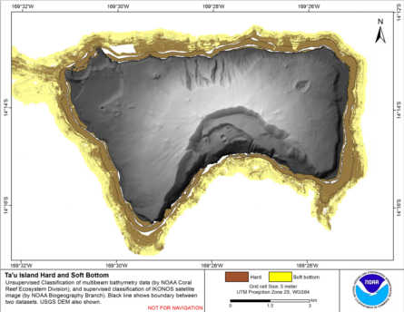
Integrated hard and soft bottom seafloor substrate map of Ta'u, American Samoa, combining
NOAA Pacific Island Fisheries Science Center Coral Reef Ecosystem Division
hard-soft substrate map with NOAA Center for Coastal Monitoring and Assessment
Biogeography Program shallow-water benthic habitat
map of American Samoa.
Hard and soft seafloor substrate map, derived from integrating
two existing map products: hard and soft seafloor substrate map
derived from an unsupervised classification of multibeam backscatter and
bathymetry derivatives, produced by NOAA Pacific Island...
Biological data collected aboard the NOAA Ship NANCY FOSTER during cruise #NF0705, March 30th - April 10th, 2007 and during larval collections in Brewer's Bay, St. Thomas April 12 - 19th, 2007
Biological data collected from plankton collecting gear aboard the NOAA Ship NANCY FOSTER during cruise #NF0705, March 30th - April 10th, 2007 as part of the Coral Reef Ecosystem Research (CRER) project and from inshore larval collections in Brewer's Bay,...
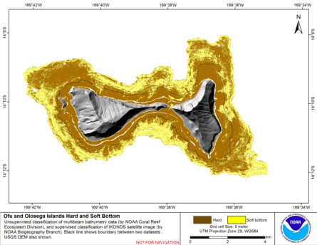
Integrated hard and soft bottom seafloor substrate map of Ofu-Olosega, American Samoa, combining
NOAA Pacific Island Fisheries Science Center Coral Reef Ecosystem Division
hard-soft substrate map with NOAA Center for Coastal Monitoring and Assessment
Biogeography Program shallow-water benthic habitat
map of American Samoa.
Hard and soft seafloor substrate map, derived from integrating
two existing map products: hard and soft seafloor substrate map
derived from an unsupervised classification of multibeam backscatter and
bathymetry derivatives, produced by NOAA Pacific Island...
Changes in growth, vitality, and habitat value of Acropora cervicornis in the US Caribbean
The project was planned to document the habitat value of Acropora cervicornis, staghorn coral, colonies or stands/thickets as they changed in configuration through growth and disturbance. Research addressed environmental condition and productivity of A. c...
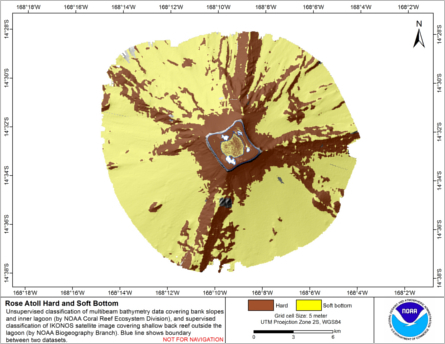
Integrated hard and soft bottom seafloor substrate map of Rose Atoll, American Samoa
combining NOAA Pacific Island Fisheries Science Center Coral Reef Ecosystem Division
hard-soft substrate maps with NOAA Center for Coastal Monitoring and Assessment Biogeography
Program shallow-water benthic habitat map of American Samoa.
Hard and soft seafloor substrate map, derived from integrating two existing map
products: hard and soft substrate maps derived from an unsupervised classification of multibeam
backscatter and bathymetry derivatives, produced by NOAA Pacific Island Fisheri...
SEFSC is responsible for monitoring and research support for coral reef ecosystems in Florida, the Gulf of Mexico and the U.S. Caribbean. These responsibilities include habitat mapping and characterization, coral reef fish and fisheries monitoring, resear...
NOAA Point Shapefile - 100m2 Fish Density of Flower Garden Banks National Marine Sanctuary, United States, R/V Manta, ROV Cruise, 2012, WGS84
The design of this field mission is three fold: (1) to spatially characterize the distribution, abundance and size of both reef fishes and macro invertebrates within and around the waters of the Flower Gardens National Marine Sanctuary, (2) to relate this...
 Habitat characterization of the Tortugas Ecological Reserve south using photographic and quadrat methods.
 Integrated hard and soft bottom seafloor substrate map of Ta'u, American Samoa, combining
NOAA Pacific Island Fisheries Science Center Coral Reef Ecosystem Division
hard-soft substrate map with NOAA Center for Coastal Monitoring and Assessment
Biogeography Program shallow-water benthic habitat
map of American Samoa.
Integrated hard and soft bottom seafloor substrate map of Ta'u, American Samoa, combining
NOAA Pacific Island Fisheries Science Center Coral Reef Ecosystem Division
hard-soft substrate map with NOAA Center for Coastal Monitoring and Assessment
Biogeography Program shallow-water benthic habitat
map of American Samoa.
 Hard and soft seafloor substrate map, derived from integrating
two existing map products: hard and soft seafloor substrate map
derived from an unsupervised classification of multibeam backscatter and
bathymetry derivatives, produced by NOAA Pacific Island...
Hard and soft seafloor substrate map, derived from integrating
two existing map products: hard and soft seafloor substrate map
derived from an unsupervised classification of multibeam backscatter and
bathymetry derivatives, produced by NOAA Pacific Island...
 Hard and soft seafloor substrate map, derived from integrating two existing map
products: hard and soft substrate maps derived from an unsupervised classification of multibeam
backscatter and bathymetry derivatives, produced by NOAA Pacific Island Fisheri...
Hard and soft seafloor substrate map, derived from integrating two existing map
products: hard and soft substrate maps derived from an unsupervised classification of multibeam
backscatter and bathymetry derivatives, produced by NOAA Pacific Island Fisheri...
 Southeast Fisheries Science Center (SEFSC)