 Assessment of coral reef communities in Hawaii, Maui, and Oahu of the Main Hawaiian Islands from 2010-03-08 to 2011-11-08 using the Line-point Intercept (LPI) method (NCEI Accession 0168913)
Integrated hard and soft bottom seafloor substrate map of Ta'u, American Samoa, combining
NOAA Pacific Island Fisheries Science Center Coral Reef Ecosystem Division
hard-soft substrate map with NOAA Center for Coastal Monitoring and Assessment
Biogeography Program shallow-water benthic habitat
map of American Samoa.
Assessment of coral reef communities in Hawaii, Maui, and Oahu of the Main Hawaiian Islands from 2010-03-08 to 2011-11-08 using the Line-point Intercept (LPI) method (NCEI Accession 0168913)
Assessment of coral reef communities in Hawaii, Maui, and Oahu of the Main Hawaiian Islands from 2010-03-08 to 2011-11-08 using the Line-point Intercept (LPI) method (NCEI Accession 0168913)
Integrated hard and soft bottom seafloor substrate map of Ta'u, American Samoa, combining
NOAA Pacific Island Fisheries Science Center Coral Reef Ecosystem Division
hard-soft substrate map with NOAA Center for Coastal Monitoring and Assessment
Biogeography Program shallow-water benthic habitat
map of American Samoa.
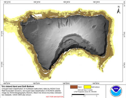 Hard and soft seafloor substrate map, derived from integrating
two existing map products: hard and soft seafloor substrate map
derived from an unsupervised classification of multibeam backscatter and
bathymetry derivatives, produced by NOAA Pacific Island...
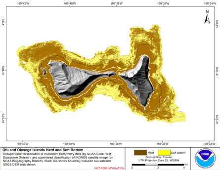
Integrated hard and soft bottom seafloor substrate map of Ofu-Olosega, American Samoa, combining
NOAA Pacific Island Fisheries Science Center Coral Reef Ecosystem Division
hard-soft substrate map with NOAA Center for Coastal Monitoring and Assessment
Biogeography Program shallow-water benthic habitat
map of American Samoa.
Hard and soft seafloor substrate map, derived from integrating
two existing map products: hard and soft seafloor substrate map
derived from an unsupervised classification of multibeam backscatter and
bathymetry derivatives, produced by NOAA Pacific Island...
Integrated hard and soft bottom seafloor substrate map of Ofu-Olosega, American Samoa, combining
NOAA Pacific Island Fisheries Science Center Coral Reef Ecosystem Division
hard-soft substrate map with NOAA Center for Coastal Monitoring and Assessment
Biogeography Program shallow-water benthic habitat
map of American Samoa.
 Hard and soft seafloor substrate map, derived from integrating
two existing map products: hard and soft seafloor substrate map
derived from an unsupervised classification of multibeam backscatter and
bathymetry derivatives, produced by NOAA Pacific Island...
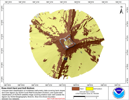
Integrated hard and soft bottom seafloor substrate map of Rose Atoll, American Samoa
combining NOAA Pacific Island Fisheries Science Center Coral Reef Ecosystem Division
hard-soft substrate maps with NOAA Center for Coastal Monitoring and Assessment Biogeography
Program shallow-water benthic habitat map of American Samoa.
Hard and soft seafloor substrate map, derived from integrating
two existing map products: hard and soft seafloor substrate map
derived from an unsupervised classification of multibeam backscatter and
bathymetry derivatives, produced by NOAA Pacific Island...
Integrated hard and soft bottom seafloor substrate map of Rose Atoll, American Samoa
combining NOAA Pacific Island Fisheries Science Center Coral Reef Ecosystem Division
hard-soft substrate maps with NOAA Center for Coastal Monitoring and Assessment Biogeography
Program shallow-water benthic habitat map of American Samoa.
 Hard and soft seafloor substrate map, derived from integrating two existing map
products: hard and soft substrate maps derived from an unsupervised classification of multibeam
backscatter and bathymetry derivatives, produced by NOAA Pacific Island Fisheri...
NOAA/NMFS/CRED Deep CTD profiles from 15 cruises near islands, atolls and shoals in the central tropical Pacific 1999-2012 (NODC Accession 0115299)
Coral reef ecosystem marine protected area monitoring in Fagamalo, American Samoa: benthic images collected during belt transect surveys in 2015
Hard and soft seafloor substrate map, derived from integrating two existing map
products: hard and soft substrate maps derived from an unsupervised classification of multibeam
backscatter and bathymetry derivatives, produced by NOAA Pacific Island Fisheri...
NOAA/NMFS/CRED Deep CTD profiles from 15 cruises near islands, atolls and shoals in the central tropical Pacific 1999-2012 (NODC Accession 0115299)
Coral reef ecosystem marine protected area monitoring in Fagamalo, American Samoa: benthic images collected during belt transect surveys in 2015
 Map of percent scleractinian coral cover and sand along camera tows and ROV tracks of West Maui, Hawaii
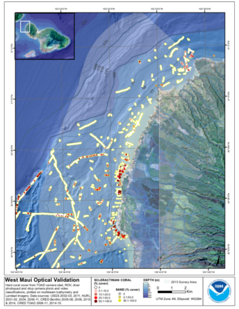 This map displays optical validation observation locations and percent coverage of scleractinian coral and sand overlaid on
bathymetry and landsat imagery. Optical data were collected by CRED TOAD camera sled aboard the Hawaiian Islands Humpback Whale Nat...
CRED SVP Drifting Buoy Argos_ID 29103 Data, Pathfinder Reef in the Marianas Archipelago, 200309-200406 (NODC Accession 0067473)
This map displays optical validation observation locations and percent coverage of scleractinian coral and sand overlaid on
bathymetry and landsat imagery. Optical data were collected by CRED TOAD camera sled aboard the Hawaiian Islands Humpback Whale Nat...
CRED SVP Drifting Buoy Argos_ID 29103 Data, Pathfinder Reef in the Marianas Archipelago, 200309-200406 (NODC Accession 0067473)
 CRED SVP drifter Argos_ID 29103 was deployed in the region of Marianas Archipelago to assess ocean currents
and sea surface temperature. SVP drifter data files contain drifter ids, year, month, day, hour, minute, second,
GPS latitude and longitude. Drifte...
CRED SVP Drifting Buoy Argos_ID 24949 Data, between Maro Reef and Raita Bank in the Northwestern Hawaiian Islands , 200109-200309 (NODC Accession 0049436)
CRED SVP drifter Argos_ID 29103 was deployed in the region of Marianas Archipelago to assess ocean currents
and sea surface temperature. SVP drifter data files contain drifter ids, year, month, day, hour, minute, second,
GPS latitude and longitude. Drifte...
CRED SVP Drifting Buoy Argos_ID 24949 Data, between Maro Reef and Raita Bank in the Northwestern Hawaiian Islands , 200109-200309 (NODC Accession 0049436)
 CRED SVP drifter Argos_ID 24949 was deployed in the region of NW Hawaiian Islands to assess ocean currents
and sea surface temperature. SVP drifter data files contain drifter ids, year, month, day, hour, minute, second,
GPS latitude and longitude. Drifter...
CRED Map of Percent Hard Coral Cover at Tutuila Island, American Samoa
CRED SVP drifter Argos_ID 24949 was deployed in the region of NW Hawaiian Islands to assess ocean currents
and sea surface temperature. SVP drifter data files contain drifter ids, year, month, day, hour, minute, second,
GPS latitude and longitude. Drifter...
CRED Map of Percent Hard Coral Cover at Tutuila Island, American Samoa
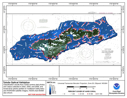 This map displays optical validation observation locations and percent coverage of hard coral overlaid on bathymetry.