Mapping and EcoSpatial Information Products to Support Coral Reef Ecosystem Management in the Pacific Islands Region
This project will continue activities undertaken by the EcoSpatial Information Team (ESIT) at the Ecosystem Sciences Division (ESD). ESIT performs an essential role, providing crosscutting data and analytical services—including the ability to collect and ...
Acoustic characterization of mesophotic coral reef ecosystems of West Hawai'i
Coral reef habitats in Hawai'i are common in shallow waters and extend into mesophotic depths (30-150 m). However, habitat monitoring efforts have been concentrated in depths constrained by safe dive limits of 0-30 m. Mesophotic coral ecosystems (MCEs), l...
Satellite-derived bathymetry for nearshore benthic habitats in the Pacific Remote Islands Marine National Monument
Bathymetric data derived from multispectral, high-resolution (2 m) satellite imagery acquired between 2011 and 2016 from Digital Globe’s WorldView-2 or WorldView-3 satellite to provide near complete coverage of nearshore terrain around several islands and...
Sampling grids to support the collection and analysis of survey data for the National Coral Reef Monitoring Program in American Samoa, Pacific Remote Islands Areas, Main Hawaiian Islands
The sampling grids are identified as essential components for the stratified random sampling design of the National Coral Reef Monitoring Program (NCRMP). The benthic habitat map layers including bathymetry, hard and soft substrates, reef zones and sector...
Depth soundings from a single beam echo sounder collected around the nearshore areas of Timor-Leste in 2012 and 2013
This dataset contains singlebeam bathymetry data acquired during small-boat surveys conducted from October 20-26, 2012 and June 4-27, 2013 in Timor-Leste by the NOAA Coral Reef Ecosystem Program (CREP). Data was acquired with a HydroLite-TM Echosounder Ki...
EM300 Multibeam Sonar Data collected from May 7 to May 22 from NOAA Ship Hi'ialakai cruise HA-17-01 to the Commonwealth of Northern Mariana Islands (CNMI) and Guam in 2017
Multibeam data were collected using a Simrad EM300 30-kHz sonar aboard NOAA Ship Hi'ialakai, a 68-m (218') NOAA research vessel, from May 7 to May 22, 2017 during cruise HA-17-01. Multibeam data were acquired at Guam and Aguijan in the Marianas. The multi...
Gridded multibeam bathymetry of Guam Island, Guam U.S. Territory
Gridded bathymetry at 60m resolution surrounding Guam Island, Guam U.S. Territory. Bottom coverage was achieved in depths between 0 and ~3500 meters. The Arc ASCII grids and floating point geotifs include multibeam bathymetry data acquired over multiple s...
EM300 Multibeam Sonar Data collected from January 26 to April 22 from NOAA Ship Hi'ialakai cruise HA-15-01 to the Pacific Remote Island Areas and American Samoa in 2015
Multibeam data were collected using a Simrad EM300 30-kHz sonar aboard NOAA Ship Hi'ialakai, a 68-m (218') NOAA research vessel, from January 26 to April 22, 2015 during cruise HA-15-01. Multibeam data were acquired at Johnston, Howland, Baker, Jarvis, an...
Benthic Habitat Maps for Rose Atoll Marine National Monument in American Samoa from 2004 to 2010
Benthic habitat maps for Rose Atoll, American Samoa were derived from high resolution, multispectral satellite imagery for 2004, 2006, and 2010. The benthic habitat maps for 2004 were previously generated by NOAA's NCCOS's BioGeography Branch before this ...
Dominant Benthic Structure and Biological Cover Habitat Maps for West Maui and West Hawaii
Benthic habitat maps depict dominant substrate type and biological cover in depths between 0 and ~150 m for two priority sites in the Main Hawaiian Islands; the NOAA Habitat Blueprint West Hawaii Focus Area (WHFA) and the Hawaii Division of Aquatic Resour...
 Mapping and EcoSpatial Information Products to Support Coral Reef Ecosystem Management in the Pacific Islands Region
 Satellite-derived bathymetry for nearshore benthic habitats in the Pacific Remote Islands Marine National Monument
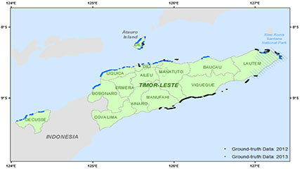 This dataset contains singlebeam bathymetry data acquired during small-boat surveys conducted from October 20-26, 2012 and June 4-27, 2013 in Timor-Leste by the NOAA Coral Reef Ecosystem Program (CREP). Data was acquired with a HydroLite-TM Echosounder Ki...
 Gridded bathymetry at 60m resolution surrounding Guam Island, Guam U.S. Territory. Bottom coverage was achieved in depths between 0 and ~3500 meters. The Arc ASCII grids and floating point geotifs include multibeam bathymetry data acquired over multiple s...
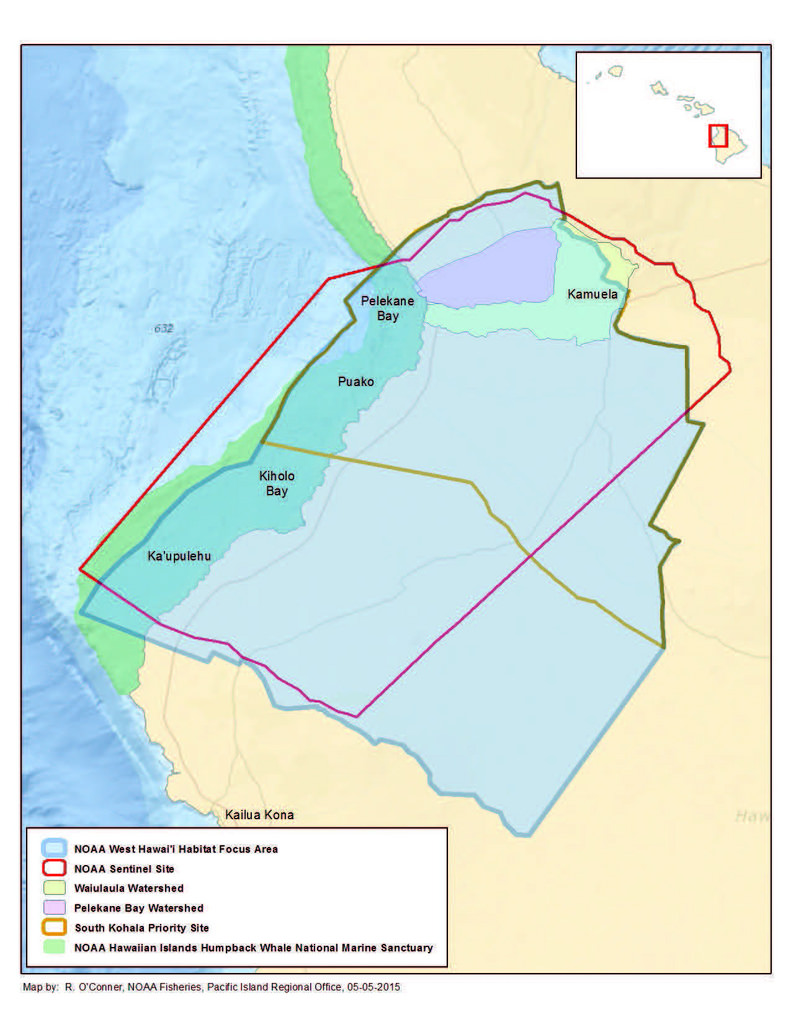 Benthic habitat maps depict dominant substrate type and biological cover in depths between 0 and ~150 m for two priority sites in the Main Hawaiian Islands; the NOAA Habitat Blueprint West Hawaii Focus Area (WHFA) and the Hawaii Division of Aquatic Resour...