
Integrated hard and soft bottom seafloor substrate map of Ta'u, American Samoa, combining
NOAA Pacific Island Fisheries Science Center Coral Reef Ecosystem Division
hard-soft substrate map with NOAA Center for Coastal Monitoring and Assessment
Biogeography Program shallow-water benthic habitat
map of American Samoa.
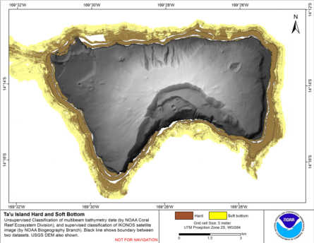
Hard and soft seafloor substrate map, derived from integrating
two existing map products: hard and soft seafloor substrate map
derived from an unsupervised classification of multibeam backscatter and
bathymetry derivatives, produced by NOAA Pacific Island...
Integrated hard and soft bottom seafloor substrate map of Ofu-Olosega, American Samoa, combining
NOAA Pacific Island Fisheries Science Center Coral Reef Ecosystem Division
hard-soft substrate map with NOAA Center for Coastal Monitoring and Assessment
Biogeography Program shallow-water benthic habitat
map of American Samoa.
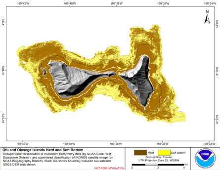
Hard and soft seafloor substrate map, derived from integrating
two existing map products: hard and soft seafloor substrate map
derived from an unsupervised classification of multibeam backscatter and
bathymetry derivatives, produced by NOAA Pacific Island...
Integrated hard and soft bottom seafloor substrate map of Rose Atoll, American Samoa
combining NOAA Pacific Island Fisheries Science Center Coral Reef Ecosystem Division
hard-soft substrate maps with NOAA Center for Coastal Monitoring and Assessment Biogeography
Program shallow-water benthic habitat map of American Samoa.
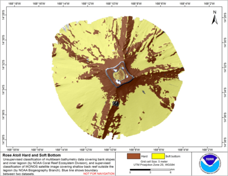
Hard and soft seafloor substrate map, derived from integrating two existing map
products: hard and soft substrate maps derived from an unsupervised classification of multibeam
backscatter and bathymetry derivatives, produced by NOAA Pacific Island Fisheri...
Eco-spatial data layers of coral reef ecosystem drivers in American Samoa
Understanding the spatial distribution, intensity, overlap, and cumulative impact of human activities and environmental stressors is essential for effective management and protection of ecosystem services generated by coral reefs. The data described here ...
Assessment of coral reef communities in Hawaii, Maui, and Oahu of the Main Hawaiian Islands from 2010-03-08 to 2011-11-08 using the Line-point Intercept (LPI) method (NCEI Accession 0168913)

This data package contains coral reef community composition data gathered during Line-Point-Intercept (LPI) surveys around the islands of Maui, Hawaii, and Oahu of the main Hawaiian Islands from March 8, 2010 to November 8, 2011 as part of a joint project...

Current application and future needs of the NOAA Pacific Islands Fisheries Science Center's Coral Reef Ecosystem Division seabed mapping program
This report presents a review of what seabed mapping is, how mapping data can be used, how CRED currently collects mapping data, and the applications to which this data can be applied, as well as recommending future applications and analyses that can make...
CRED Shallow CTD Profiles; Maro Reef, Northwestern Hawaiian Islands (Papahanaumokuakea Marine National Monument); Cruise: HI0401, Data Date Range: 20040921-20040923 (NODC Accession 0039382).
CRED shallow Conductivity-Temperature-Depth (CTD) casts are vertical profiles (max 30 meter depth, downcast only) of temperature, conductivity and pressure. Data are collected at select nearshore locations, both around islands or banks and within lagoons...
 Hard and soft seafloor substrate map, derived from integrating
two existing map products: hard and soft seafloor substrate map
derived from an unsupervised classification of multibeam backscatter and
bathymetry derivatives, produced by NOAA Pacific Island...
Hard and soft seafloor substrate map, derived from integrating
two existing map products: hard and soft seafloor substrate map
derived from an unsupervised classification of multibeam backscatter and
bathymetry derivatives, produced by NOAA Pacific Island...
 Hard and soft seafloor substrate map, derived from integrating two existing map
products: hard and soft substrate maps derived from an unsupervised classification of multibeam
backscatter and bathymetry derivatives, produced by NOAA Pacific Island Fisheri...
Hard and soft seafloor substrate map, derived from integrating two existing map
products: hard and soft substrate maps derived from an unsupervised classification of multibeam
backscatter and bathymetry derivatives, produced by NOAA Pacific Island Fisheri...
 Slope is derived from gridded (10 m cell size) multibeam
bathymetry, collected aboard NOAA Ship Hiialaka'i and R/V AHI.
Cell values reflect the maximum rate of change (in degrees) in
elevation between neighboring cells derived with the ArcGIS
Spatial Anal...
Slope is derived from gridded (10 m cell size) multibeam
bathymetry, collected aboard NOAA Ship Hiialaka'i and R/V AHI.
Cell values reflect the maximum rate of change (in degrees) in
elevation between neighboring cells derived with the ArcGIS
Spatial Anal...
 Water samples are collected and analyzed to assess spatial and temporal variation in the seawater carbonate systems of coral reef ecosystems in the Hawaiian and Mariana Archipelagos, American Samoa, and the Pacific Remote Island Areas as part of the NOAA ...