 Bathymetric Position Index (BPI) Structures 5 m grid derived from gridded bathymetry of Galvez Bank, South Galvez Bank, and 11-Mile Reef, Territory of Guam, USA.
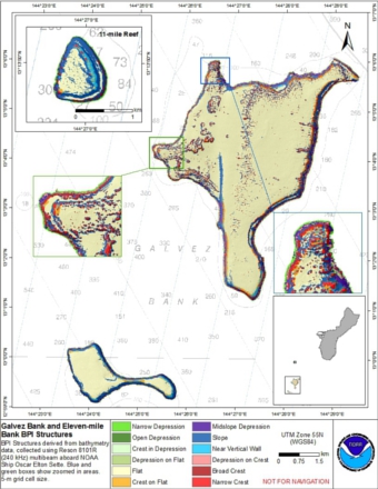 BPI Structures are derived from two scales of a focal mean
analysis on bathymetry and slope. The grid is based on
gridded (5 m cell size) multibeam bathymetry, collected aboard NOAA Ship Oscar Elton Sette.
BPI Structures was created using the Benthic Terr...
BPI Structures are derived from two scales of a focal mean
analysis on bathymetry and slope. The grid is based on
gridded (5 m cell size) multibeam bathymetry, collected aboard NOAA Ship Oscar Elton Sette.
BPI Structures was created using the Benthic Terr...
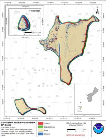 BPI Zones are derived from a focal mean
analysis on bathymetry and slope. The grid is based on
gridded (5 m cell size) multibeam bathymetry, collected aboard NOAA Ship Oscar Elton Sette.
BPI Zones was created using the Benthic
Terrain Modeler (https://coa...
BPI Zones are derived from a focal mean
analysis on bathymetry and slope. The grid is based on
gridded (5 m cell size) multibeam bathymetry, collected aboard NOAA Ship Oscar Elton Sette.
BPI Zones was created using the Benthic
Terrain Modeler (https://coa...
 Rugosity is derived from gridded (5 m cell size) multibeam bathymetry, aboard NOAA Ship Oscar Elton Sette. Cell values reflect the (surface area) / (planimetric area) ratio for the area contained within that cell's boundaries. They provide indices o...
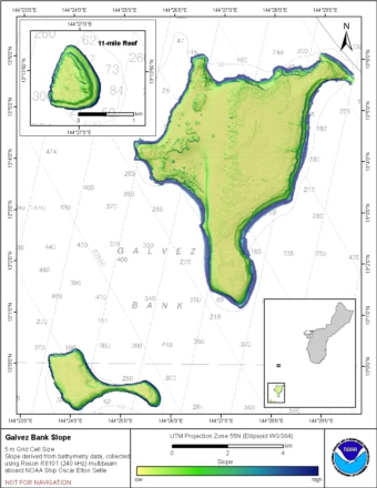 Slope is derived from gridded (5 m cell size) multibeam
bathymetry, collected aboard NOAA Ship Oscar Elton Sette.
Cell values reflect the maximum rate of change (in degrees) in
elevation between neighboring cells derived with the ArcGIS
Spatial Analyst ex...
Slope is derived from gridded (5 m cell size) multibeam
bathymetry, collected aboard NOAA Ship Oscar Elton Sette.
Cell values reflect the maximum rate of change (in degrees) in
elevation between neighboring cells derived with the ArcGIS
Spatial Analyst ex...
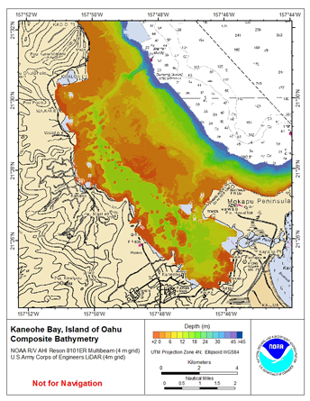 4-m grid of bathymetric data of Kaneohe Bay, Windward Side Oahu, Main Hawaiian Islands, USA.
These netCDF and ASCII grids include multibeam bathymetry from the Reson 8101 multibeam sonar collected by the
National Oceanic and Atmospheric Administration (N...
4-m grid of bathymetric data of Kaneohe Bay, Windward Side Oahu, Main Hawaiian Islands, USA.
These netCDF and ASCII grids include multibeam bathymetry from the Reson 8101 multibeam sonar collected by the
National Oceanic and Atmospheric Administration (N...
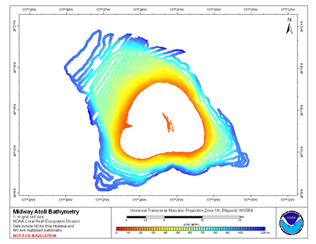 Gridded bathymetry of the shelf and slope environments of Midway Atoll,
Hawaii, USA. Bottom coverage was achieved in depths between 0 and 200 meters.
The ASCII includes multibeam bathymetry from the Simrad EM300, Simrad EM3002d,
and Reson 8101 multibeam s...
Gridded bathymetry of the shelf and slope environments of Midway Atoll,
Hawaii, USA. Bottom coverage was achieved in depths between 0 and 200 meters.
The ASCII includes multibeam bathymetry from the Simrad EM300, Simrad EM3002d,
and Reson 8101 multibeam s...
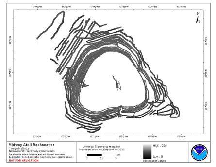 Multibeam backscatter imagery extracted from gridded
bathymetry of Midway Atoll, Northwestern Hawaiian Islands, USA.
These data provide coverage between 0 and 200 meters. The
backscatter dataset includes data collected using the Reson 8101
multibeam sonar...
Multibeam backscatter imagery extracted from gridded
bathymetry of Midway Atoll, Northwestern Hawaiian Islands, USA.
These data provide coverage between 0 and 200 meters. The
backscatter dataset includes data collected using the Reson 8101
multibeam sonar...
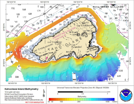 Gridded bathymetry (10m) of Kahoolawe Island, Hawaii, USA.
The data include multibeam bathymetry from the EM120, EM122, EM710, EM1020, and EM1002 multibeam sonar collected
by the Hawai'i Undersea Research Laboratory of the University of Hawaii in depths b...
Gridded bathymetry (10m) of Kahoolawe Island, Hawaii, USA.
The data include multibeam bathymetry from the EM120, EM122, EM710, EM1020, and EM1002 multibeam sonar collected
by the Hawai'i Undersea Research Laboratory of the University of Hawaii in depths b...
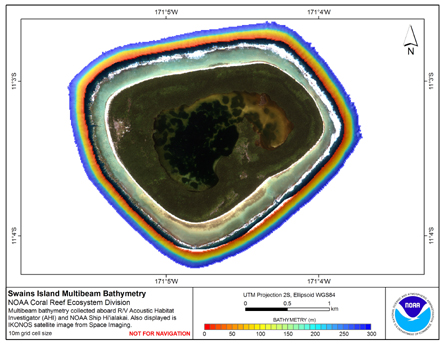 Gridded (10 m cell size) bathymetry of the slope environment of
Swains Island, American Samoa, South Pacific.
Almost complete bottom coverage was achieved in depths between
7 and 4800 meters (10 m grid includes data to 300 m). The bathymetry dataset
inclu...
Gridded (10 m cell size) bathymetry of the slope environment of
Swains Island, American Samoa, South Pacific.
Almost complete bottom coverage was achieved in depths between
7 and 4800 meters (10 m grid includes data to 300 m). The bathymetry dataset
inclu...