
CRED Fish Observations from Stereo Video Cameras on a SeaBED AUV collected around Tutuila, American Samoa in 2012
Black and white imagery were collected using a stereo pair of underwater video cameras mounted on a SeaBED autonomous
underwater vehicle (AUV) and deployed around the island of Tutuila in American Samoa to record observations of fishes
encountered there. ...

CRED Optical Validation Data collected on Hawai'i (Big Island), Main Hawaiian Islands, USA, in 2012 to support Benthic Habitat Mapping
Optical validation data were collected using a Tethered Optical Assessment Device (TOAD), an underwater sled
equipped with an underwater digital video camera, digital still camera and lights, in the Kohala coast area of northwest Hawaii island. Data were...
CRED Optical Validation Data collected on Maui, Main Hawaiian Islands, USA, in 2014 to support Benthic Habitat Mapping
Optical validation data were collected using a Tethered Optical Assessment Device (TOAD), an underwater sled
equipped with an underwater digital video camera, digital still camera and lights, in the Kahekili coast area of western Maui island. Data were c...
CRED Optical Validation Data collected on Maui, Main Hawaiian Islands, USA, in 2015 to support Benthic Habitat Mapping
Optical validation data were collected using a Tethered Optical Assessment Device (TOAD), an underwater sled
equipped with an underwater digital video camera, digital still camera and lights, along the western Maui island coastline from Honolua Bay to Mal...
 Bathymetric data derived from a multispectral World View-2 satellite
image mosaiced to provide near complete coverage of nearshore
terrain around the islands. Bathymetry values shallower than ~20 m were
derived by gauging the relative attenuation of coast...
Bathymetric data derived from a multispectral World View-2 satellite
image mosaiced to provide near complete coverage of nearshore
terrain around the islands. Bathymetry values shallower than ~20 m were
derived by gauging the relative attenuation of coast...
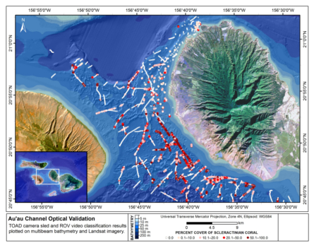
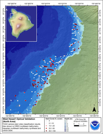 This map displays optical validation observation locations and percent coverage of scleractinian coral and sand overlaid on
bathymetry and landsat imagery northwest of Hawai'i island. Optical data were collected by CRED TOAD camera sled from the
Hawaiian ...
This map displays optical validation observation locations and percent coverage of scleractinian coral and sand overlaid on
bathymetry and landsat imagery northwest of Hawai'i island. Optical data were collected by CRED TOAD camera sled from the
Hawaiian ...
 Optical validation data were collected using the Tethered Optical Assessment Device (TOAD), a sled equipped with
underwater video camera, still camera and lights. Camera sled deployments were conducted during the day, from the contracted vessel
Bonavista ...
Optical validation data were collected using the Tethered Optical Assessment Device (TOAD), a sled equipped with
underwater video camera, still camera and lights. Camera sled deployments were conducted during the day, from the contracted vessel
Bonavista ...
 Optical validation data were collected using the Tethered Optical Assessment Device (TOAD), a sled equipped with underwater
video camera, still camera and lights. Camera sled deployments were conducted during the day, from the contracted vessel Bonavista ...
Optical validation data were collected using the Tethered Optical Assessment Device (TOAD), a sled equipped with underwater
video camera, still camera and lights. Camera sled deployments were conducted during the day, from the contracted vessel Bonavista ...
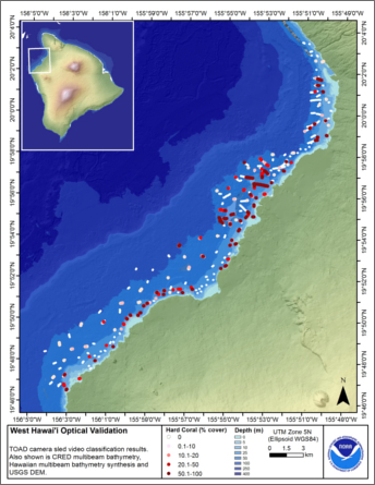 This map displays optical validation observation locations and percent coverage of scleractinian coral overlaid on
bathymetry and landsat imagery northwest of Hawai'i island. Optical data were collected by CRED TOAD camera sled from the
Hawai'ian Islands ...
This map displays optical validation observation locations and percent coverage of scleractinian coral overlaid on
bathymetry and landsat imagery northwest of Hawai'i island. Optical data were collected by CRED TOAD camera sled from the
Hawai'ian Islands ...
 This map displays optical validation observation locations and percent coverage of scleractinian coral overlaid on
bathymetry and landsat imagery. Optical data were collected by CRED TOAD camera sled aboard the Hawaiian Islands Humpback
Whale National Mar...
This map displays optical validation observation locations and percent coverage of scleractinian coral overlaid on
bathymetry and landsat imagery. Optical data were collected by CRED TOAD camera sled aboard the Hawaiian Islands Humpback
Whale National Mar...