 Bathymetric Position Index (BPI) Structures 5m grid derived from gridded bathymetry of Saipan Island,
Commonwealth of the Northern Marianas
Bathymetric Position Index (BPI) Structures 5m grid derived from gridded bathymetry of Saipan Island,
Commonwealth of the Northern Marianas
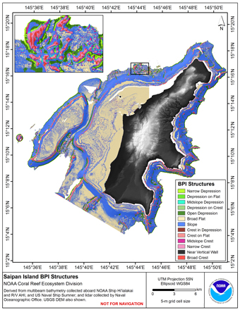 BPI Structures are derived from a focal mean analysis on bathymetry and slope.
The bathymetry grid (5 m cell size) is derived from two sources:
Multibeam bathymetry collected by Coral Reef Ecosystem Division aboard NOAA R/V AHI, and
NOAA Ship Hi'ialakai; ...
BPI Structures are derived from a focal mean analysis on bathymetry and slope.
The bathymetry grid (5 m cell size) is derived from two sources:
Multibeam bathymetry collected by Coral Reef Ecosystem Division aboard NOAA R/V AHI, and
NOAA Ship Hi'ialakai; ...
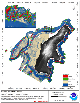 BPI Zones are derived from a focal mean analysis on bathymetry and slope.
The bathymetry grid (5 m cell size) is derived from bathymetry from two sources:
Multibeam bathymetry collected by Coral Reef Ecosystem Division aboard NOAA R/V AHI, and
NOAA Ship H...
BPI Zones are derived from a focal mean analysis on bathymetry and slope.
The bathymetry grid (5 m cell size) is derived from bathymetry from two sources:
Multibeam bathymetry collected by Coral Reef Ecosystem Division aboard NOAA R/V AHI, and
NOAA Ship H...
 Rugosity is derived from gridded (5 m cell size) bathymetry from two sources:
Multibeam bathymetry collected by Coral Reef Ecosystem Division aboard NOAA R/V AHI, and
NOAA Ship Hi'ialakai; multibeam bathymetry collected aboard the US Naval Ship Sumner by ...
Rugosity is derived from gridded (5 m cell size) bathymetry from two sources:
Multibeam bathymetry collected by Coral Reef Ecosystem Division aboard NOAA R/V AHI, and
NOAA Ship Hi'ialakai; multibeam bathymetry collected aboard the US Naval Ship Sumner by ...
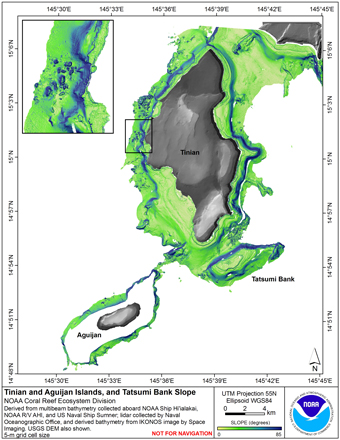 Slope is derived from gridded (5 m cell size) bathymetry from two sources:
Multibeam bathymetry collected by Coral Reef Ecosystem Division aboard NOAA R/V AHI, and
NOAA Ship Hi'ialakai; multibeam bathymetry collected aboard the US Naval Ship Sumner by the...
Slope is derived from gridded (5 m cell size) bathymetry from two sources:
Multibeam bathymetry collected by Coral Reef Ecosystem Division aboard NOAA R/V AHI, and
NOAA Ship Hi'ialakai; multibeam bathymetry collected aboard the US Naval Ship Sumner by the...