 Bathymetric Position Index (BPI) Structures 5 m grid derived from gridded
bathymetry of Brooks Banks, Hawaii, USA.
Bathymetric Position Index (BPI) Structures 5 m grid derived from gridded
bathymetry of Brooks Banks, Hawaii, USA.
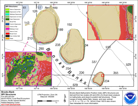 BPI Structures are derived from two scales of a focal mean
analysis on bathymetry and slope. The grid is based on
gridded (5 m cell size) multibeam bathymetry, collected aboard NOAA ship Hi'ialakai
and R/V AHI. It was created using the Benthic
Terrain Mo...
BPI Structures are derived from two scales of a focal mean
analysis on bathymetry and slope. The grid is based on
gridded (5 m cell size) multibeam bathymetry, collected aboard NOAA ship Hi'ialakai
and R/V AHI. It was created using the Benthic
Terrain Mo...
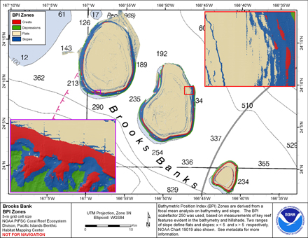 BPI Zones are derived from a focal mean analysis on
bathymetry and slope. The grid is based on
gridded (5 m cell size) multibeam bathymetry, collected aboard NOAA ship
Hi'ialakai and R/V AHI. It was created using the Benthic
Terrain Modeler (http://www.cs...
BPI Zones are derived from a focal mean analysis on
bathymetry and slope. The grid is based on
gridded (5 m cell size) multibeam bathymetry, collected aboard NOAA ship
Hi'ialakai and R/V AHI. It was created using the Benthic
Terrain Modeler (http://www.cs...
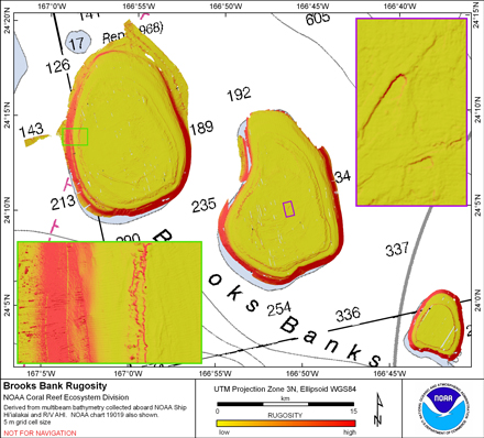 Rugosity is derived from gridded (5 m cell size)
multibeam bathymetry, collected aboard NOAA ship Hi'ialakai and R/V AHI using the
Benthic Terrain Modeler with rugosity methods by Jeff Jenness (2003).
Cell values reflect the (surface area) / (planimetric ...
Rugosity is derived from gridded (5 m cell size)
multibeam bathymetry, collected aboard NOAA ship Hi'ialakai and R/V AHI using the
Benthic Terrain Modeler with rugosity methods by Jeff Jenness (2003).
Cell values reflect the (surface area) / (planimetric ...
 Slope is derived from gridded (5 m cell size) multibeam
bathymetry, collected aboard NOAA ship Hi'ialakai and R/V AHI.
Cell values reflect the maximum rate of change (in degrees) in
elevation between neighboring cells derived with the ArcGIS
Spatial Analy...
Slope is derived from gridded (5 m cell size) multibeam
bathymetry, collected aboard NOAA ship Hi'ialakai and R/V AHI.
Cell values reflect the maximum rate of change (in degrees) in
elevation between neighboring cells derived with the ArcGIS
Spatial Analy...
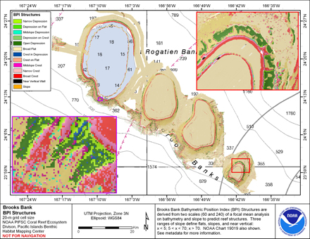 BPI Structures are derived from two scales of a focal mean
analysis on bathymetry and slope. The grid is based on
gridded (20 m cell size) multibeam bathymetry, collected aboard NOAA ship Hi'ialakai
and R/V AHI. It was created using the Benthic
Terrain M...
BPI Structures are derived from two scales of a focal mean
analysis on bathymetry and slope. The grid is based on
gridded (20 m cell size) multibeam bathymetry, collected aboard NOAA ship Hi'ialakai
and R/V AHI. It was created using the Benthic
Terrain M...
 BPI Zones are derived from a focal mean analysis on
bathymetry and slope. The grid is based on
gridded (20 m cell size) multibeam bathymetry, collected aboard NOAA ship Hi'ialakai
and R/V AHI. It was created using the Benthic
Terrain Modeler (http://www.c...
BPI Zones are derived from a focal mean analysis on
bathymetry and slope. The grid is based on
gridded (20 m cell size) multibeam bathymetry, collected aboard NOAA ship Hi'ialakai
and R/V AHI. It was created using the Benthic
Terrain Modeler (http://www.c...
 Rugosity is derived from gridded (20 m cell size)
multibeam bathymetry, collected aboard NOAA ship Hi'ialakai and R/V AHI using the
Benthic Terrain Modeler with rugosity methods by Jeff Jenness (2003).
Cell values reflect the (surface area) / (planimetric...
Rugosity is derived from gridded (20 m cell size)
multibeam bathymetry, collected aboard NOAA ship Hi'ialakai and R/V AHI using the
Benthic Terrain Modeler with rugosity methods by Jeff Jenness (2003).
Cell values reflect the (surface area) / (planimetric...
 Slope is derived from gridded (20 m cell size) multibeam
bathymetry, collected aboard NOAA ship Hi'ialakai and R/V AHI.
Cell values reflect the maximum rate of change (in degrees) in
elevation between neighboring cells derived with the ArcGIS
Spatial Anal...
Slope is derived from gridded (20 m cell size) multibeam
bathymetry, collected aboard NOAA ship Hi'ialakai and R/V AHI.
Cell values reflect the maximum rate of change (in degrees) in
elevation between neighboring cells derived with the ArcGIS
Spatial Anal...