 Bathymetric Position Index (BPI) Zones 5 m grid derived from gridded
bathymetry of Rose Atoll, Territory of American Samoa, USA.
Bathymetric Position Index (BPI) Zones 5 m grid derived from gridded
bathymetry of Rose Atoll, Territory of American Samoa, USA.
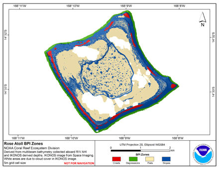 BPI Zones are derived from a focal mean
analysis on bathymetry and slope. The grid is based on
gridded (5 m cell size) multibeam bathymetry, collected aboard R/V AHI
merged with seafloor depths derived from multispectral
IKONOS satellite imagery. BPI Zon...
BPI Zones are derived from a focal mean
analysis on bathymetry and slope. The grid is based on
gridded (5 m cell size) multibeam bathymetry, collected aboard R/V AHI
merged with seafloor depths derived from multispectral
IKONOS satellite imagery. BPI Zon...
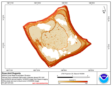 Rugosity is derived from gridded (5 m cell size) multibeam
bathymetry, collected aboard R/V AHI, and bathymetry
derived from multispectral IKONOS satellite imagery.
Cell values reflect the (surface area) / (planimetric area)
ratio for the area contained w...
Rugosity is derived from gridded (5 m cell size) multibeam
bathymetry, collected aboard R/V AHI, and bathymetry
derived from multispectral IKONOS satellite imagery.
Cell values reflect the (surface area) / (planimetric area)
ratio for the area contained w...
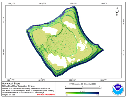 Slope is derived from gridded (5 m cell size) multibeam
bathymetry, collected aboard R/V AHI, and bathymetry
derived from multispectral IKONOS satellite imagery.
Cell values reflect the maximum rate of change (in degrees) in
elevation between neighboring ...
Slope is derived from gridded (5 m cell size) multibeam
bathymetry, collected aboard R/V AHI, and bathymetry
derived from multispectral IKONOS satellite imagery.
Cell values reflect the maximum rate of change (in degrees) in
elevation between neighboring ...