 Bathymetric Position Index (BPI) Structures 5 m grid derived from gridded bathymetry of
the US Territory of Guam.
Bathymetric Position Index (BPI) Structures 5 m grid derived from gridded bathymetry of
the US Territory of Guam.
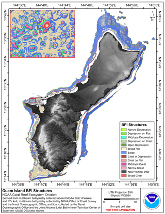 BPI Structures are derived from a focal mean analysis on bathymetry and slope.
The bathymetry grid (5 m cell size) is derived from bathymetry from four sources:
Multibeam bathymetry collected by Coral Reef Ecosystem Division aboard NOAA R/V AHI, and
NOAA ...
BPI Structures are derived from a focal mean analysis on bathymetry and slope.
The bathymetry grid (5 m cell size) is derived from bathymetry from four sources:
Multibeam bathymetry collected by Coral Reef Ecosystem Division aboard NOAA R/V AHI, and
NOAA ...
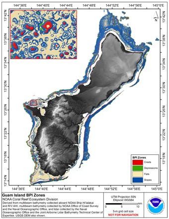 BPI Zones are derived from a focal mean analysis on bathymetry and slope.
The bathymetry grid (5 m cell size) is derived from bathymetry from four sources:
Multibeam bathymetry collected by Coral Reef Ecosystem Division aboard NOAA R/V AHI, and
NOAA Ship ...
BPI Zones are derived from a focal mean analysis on bathymetry and slope.
The bathymetry grid (5 m cell size) is derived from bathymetry from four sources:
Multibeam bathymetry collected by Coral Reef Ecosystem Division aboard NOAA R/V AHI, and
NOAA Ship ...
 Rugosity is derived from gridded (5 m cell size) bathymetry from four sources:
Multibeam bathymetry collected by Coral Reef Ecosystem Division aboard NOAA R/V AHI, and
NOAA Ship Hi'ialakai; multibeam bathymetry collected in Apra Harbor by the Naval Oceano...
Rugosity is derived from gridded (5 m cell size) bathymetry from four sources:
Multibeam bathymetry collected by Coral Reef Ecosystem Division aboard NOAA R/V AHI, and
NOAA Ship Hi'ialakai; multibeam bathymetry collected in Apra Harbor by the Naval Oceano...
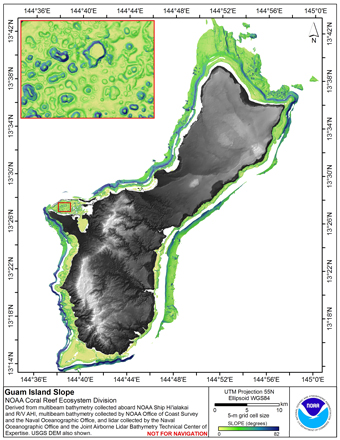 Slope is derived from gridded (5 m cell size) bathymetry from four sources:
Multibeam bathymetry collected by Coral Reef Ecosystem Division aboard NOAA R/V AHI, and
NOAA Ship Hi'ialakai; multibeam bathymetry collected in Apra Harbor by the Naval Oceanogra...
Slope is derived from gridded (5 m cell size) bathymetry from four sources:
Multibeam bathymetry collected by Coral Reef Ecosystem Division aboard NOAA R/V AHI, and
NOAA Ship Hi'ialakai; multibeam bathymetry collected in Apra Harbor by the Naval Oceanogra...