
CRED REA Fish Team Belt Transect Surveys at Baker Island, 2004
Belt transects along 3 consecutively-placed, 25m transect lines were
surveyed as part of Rapid Ecological Assessments conducted at 6 sites at
Baker Island in January, 2004 NOAA vessel Oscar Elton Sette (OES04-01).
Raw survey data included species level ab...
CRED REA Fish Team Stationary Point Count Surveys at Baker Island, 2004
Stationary Point Counts at 4 stations at each survey site were surveyed as
part of Rapid Ecological Assessments conducted at 6 sites at Baker Islands
in January, 2004 NOAA vessel Oscar Elton Sette (OES04-01). Raw survey data
included species level abundan...
 CRED 5 m Gridded bathymetry of Baker Island, Pacific Remote Island Areas, Central Pacific (Arc ASCII Format)
 Gridded (5 m cell size) bathymetry of the shelf and slope environments
of Baker Island, Pacific Remote Isand Areas, Central Pacific.
Almost complete bottom coverage was achieved in depths between
8 and 4700 meters (5 m grid includes data to 300 m). The ba...
Gridded (5 m cell size) bathymetry of the shelf and slope environments
of Baker Island, Pacific Remote Isand Areas, Central Pacific.
Almost complete bottom coverage was achieved in depths between
8 and 4700 meters (5 m grid includes data to 300 m). The ba...
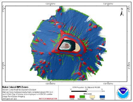 BPI Zones are derived from gridded (20 m cell size) multibeam
bathymetry, collected aboard R/V AHI and NOAA ship Hi'ialakai.
BPI Zones was created using the Benthic Terrain Modeler (http://www.csc.noaa.gov/products/btm/).
Cell values represent one of 4 cl...
BPI Zones are derived from gridded (20 m cell size) multibeam
bathymetry, collected aboard R/V AHI and NOAA ship Hi'ialakai.
BPI Zones was created using the Benthic Terrain Modeler (http://www.csc.noaa.gov/products/btm/).
Cell values represent one of 4 cl...
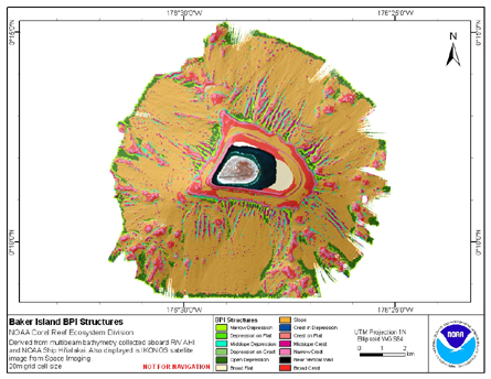 BPI Structures are derived from two scales of a focal mean
analysis on bathymetry and slope. The grid is based on
gridded (20 m cell size) multibeam bathymetry, collected aboard R/V AHI
and NOAA ship Hi'ialakai. BPI Structures was created using the Benth...
BPI Structures are derived from two scales of a focal mean
analysis on bathymetry and slope. The grid is based on
gridded (20 m cell size) multibeam bathymetry, collected aboard R/V AHI
and NOAA ship Hi'ialakai. BPI Structures was created using the Benth...
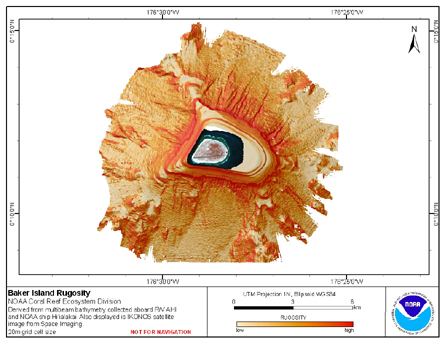 Rugosity is derived from gridded (20 m cell size) multibeam
bathymetry, collected aboard R/V AHI and NOAA ship Hi'ialakai.
Cell values reflect the (surface area) / (planimetric area)
ratio for the area contained within that cell's boundaries. They
provid...
Rugosity is derived from gridded (20 m cell size) multibeam
bathymetry, collected aboard R/V AHI and NOAA ship Hi'ialakai.
Cell values reflect the (surface area) / (planimetric area)
ratio for the area contained within that cell's boundaries. They
provid...
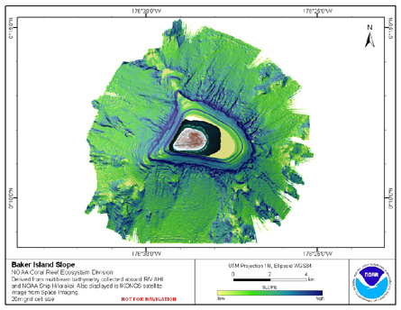 Slope is derived from gridded (20 m cell size) multibeam
bathymetry, collected aboard R/V AHI, and NOAA ship Hi'ialakai.
Cell values reflect the maximum rate of change (in degrees) in
elevation between neighboring cells derived with the ArcGIS
Spatial Ana...
Slope is derived from gridded (20 m cell size) multibeam
bathymetry, collected aboard R/V AHI, and NOAA ship Hi'ialakai.
Cell values reflect the maximum rate of change (in degrees) in
elevation between neighboring cells derived with the ArcGIS
Spatial Ana...
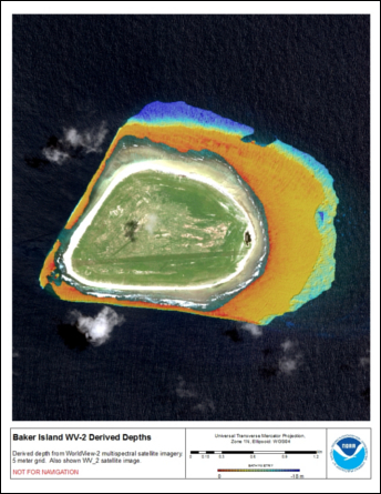 Bathymetric data derived from a multipectral World View-2 satellite
image mosaiced to provide near complete coverage of nearshore
terrain around the islands. Bathymetry values shallower than ~20 m were
derived by gauging the reletive attenuation of coasta...
Bathymetric data derived from a multipectral World View-2 satellite
image mosaiced to provide near complete coverage of nearshore
terrain around the islands. Bathymetry values shallower than ~20 m were
derived by gauging the reletive attenuation of coasta...
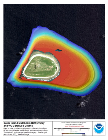 Gridded multibeam bathymetry is integrated with bathymetry
derived from multpectral World View-2 satellite data. Gridded (10 m cell
size) multibeam bathymetry collected aboard NOAA Ship Hiialaka'i and
R/V AHI in 2007, a 224 (68 m) United States National O...
Gridded multibeam bathymetry is integrated with bathymetry
derived from multpectral World View-2 satellite data. Gridded (10 m cell
size) multibeam bathymetry collected aboard NOAA Ship Hiialaka'i and
R/V AHI in 2007, a 224 (68 m) United States National O...