CRED REA Fish Team Belt Transect Surveys at the Jarvis Islands, 2004
Belt transects along 3 consecutively-placed, 25m transect lines were
surveyed as part of Rapid Ecological Assessments conducted at 6 sites at
Jarvis Island in March, 2004 from the NOAA vessel Oscar Elton Sette
(OES04-04). Raw survey data included species ...
CRED REA Fish Team Stationary Point Count Surveys at the Jarvis Island, 2004
Stationary Point Counts at 4 stations at each survey site were surveyed as
part of Rapid Ecological Assessments conducted at 6 sites at Jarvis
Island in March from the NOAA vessel Oscar Elton Sette (OES04-04).
Raw survey data included species level abunda...
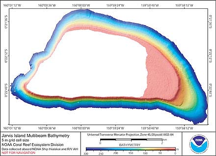
CRED 5 m Gridded bathymetry of Jarvis Island, Pacific Remote Island Areas, Central Pacific (Arc ASCII Format)
Gridded (5 m cell size) bathymetry of the shelf and slope environments
of Jarvis Island, Pacific Remote Island Areas, Central Pacific.
Almost complete bottom coverage was achieved in depths between
3 and 3600 meters (5 m grid includes data to 300 m). The ...
CRED 5 m Gridded bathymetry of Jarvis Island, Pacific Remote Island Areas, Central Pacific (NetCDF Format)
Gridded (5 m cell size) bathymetry of the shelf and slope environments
of Jarvis Island, Pacific Remote Island Areas, Central Pacific.
Almost complete bottom coverage was achieved in depths between
3 and 3600 meters (5 m grid includes data to 300 m). The ...
CRED 20 m Gridded bathymetry of Jarvis Island, Pacific Remote Island Areas, Central Pacific (NetCDF Format)
Gridded (20 m cell size) bathymetry of the shelf and slope
environments of Jarvis Island, Pacific Remote Island Areas, Central Pacific.
Almost complete bottom coverage was achieved in depths between
3 and 3600 meters. The bathymetry dataset includes Simra...
CRED 20 m Gridded bathymetry of Jarvis Island, Pacific Remote Island Areas, Central Pacific (Arc ASCII Format)
Gridded (20 m cell size) bathymetry of the shelf and slope
environments of Jarvis Island, Pacific Remote Island Areas, Central Pacific.
Almost complete bottom coverage was achieved in depths between
3 and 3600 meters. The bathymetry dataset includes Simra...
2006 Reson 8101ER Multibeam Sonar Data from Cruise
AHI-06-04 - Pacific Remote Island Areas
Reson 8101ER multibeam Data were collected in
15 March to 8 April 2006 aboard NOAA Survey Launch Acoustic
Habitat Investigator (AHI) at Jarvis Island, Palmyra,
Island, and Kingman Island in the Central Pacific during
cruise AHI-06-04. These multibeam dat...
2006 EM300 Multibeam Sonar Data from Cruise
Hi'ialakai HI-06-04 - Pacific Remote Island Areas
EM300 multibeam data were collected in
15 March to 8 April 2006 aboard NOAA Ship Hi'ialakai at
Jarvis Island, Palmyra Island, and Kingman Island in the
Central Pacific during cruise HI-06-04. These multibeam
data were collected using SAIC ISS-2000 softwa...
CRED Rapid Ecological Assessment Line Point Intercept Survey
of Benthic Parameter Assessments at Jarvis, Pacific Remote
Island Areas in 2012
Line point intercept (LPI) surveys and benthic composition
assessments were conducted during Rapid Ecological
Assessments (REA) as part of the Pacific Reef Assessment and
Monitoring Program (RAMP) cruise HA1...
CRED Towed-Diver Fish Biomass Survey at Jarvis, Pacific
Remote Island Areas in 2012
To support NOAA Coral Reef Conservation Program (CRCP)
long-term goals for sustainable management and conservation
of coral reef ecosystems, towed-diver surveys (AKA towboard
surveys) are conducted by the Co...
 CRED REA Fish Team Belt Transect Surveys at the Jarvis Islands, 2004
 CRED 5 m Gridded bathymetry of Jarvis Island, Pacific Remote Island Areas, Central Pacific (Arc ASCII Format)
 Gridded (5 m cell size) bathymetry of the shelf and slope environments
of Jarvis Island, Pacific Remote Island Areas, Central Pacific.
Almost complete bottom coverage was achieved in depths between
3 and 3600 meters (5 m grid includes data to 300 m). The ...
Gridded (5 m cell size) bathymetry of the shelf and slope environments
of Jarvis Island, Pacific Remote Island Areas, Central Pacific.
Almost complete bottom coverage was achieved in depths between
3 and 3600 meters (5 m grid includes data to 300 m). The ...
 Gridded (20 m cell size) bathymetry of the shelf and slope
environments of Jarvis Island, Pacific Remote Island Areas, Central Pacific.
Almost complete bottom coverage was achieved in depths between
3 and 3600 meters. The bathymetry dataset includes Simra...
Gridded (20 m cell size) bathymetry of the shelf and slope
environments of Jarvis Island, Pacific Remote Island Areas, Central Pacific.
Almost complete bottom coverage was achieved in depths between
3 and 3600 meters. The bathymetry dataset includes Simra...