
CRED REA Fish Team Belt Transect Surveys at Howland Island, 2004
Belt transects along 3 consecutively-placed, 25m transect lines were
surveyed as part of Rapid Ecological Assessments conducted at 5 sites at
Howland Island in January, 2004 NOAA vessel Oscar Elton Sette (OES04-01).
Raw survey data included species level ...
CRED REA Fish Team Stationary Point Count Surveys at Howland Island, 2004
Stationary Point Counts at 4 stations at each survey site were surveyed as
part of Rapid Ecological Assessments conducted at 5 sites at Howland
Island in January, 2004 NOAA vessel Oscar Elton Sette (OES0401).
Raw survey data included species level abundan...
CRED Optical Validation Data at Howland Island in the Pacific Remote Islands Area (PRIA), 2004, to Support Benthic Habitat Mapping
Optical validation data were collected using a Tethered Optical Assessment Device (TOAD), an underwater sled
equipped with an underwater digital video camera and lights. Data were collected in the Pacific Remote Islands Area
(PRIA), around Howland Island...
CRED Optical Validation Data at Howland Island in the Pacific Remote Islands Area (PRIA), 2002, to Support Benthic Habitat Mapping
Optical validation data were collected using a Tethered Optical Assessment Device (TOAD), an underwater
sled equipped with an underwater digital video camera and lights. Data were collected at Howland Island to support
Benthic Habitat Mapping efforts duri...
 CRED 5 m Gridded bathymetry of Howland Island, Pacific Remote Island Areas, Central Pacific (Arc ASCII Format)
 Gridded (5 m cell size) bathymetry of the shelf and slope environments
of Howland Island, Pacific Remote Island Areas, Central Pacific.
Almost complete bottom coverage was achieved in depths between 8 and
3800 meters (5 m grid includes depths to 300 m). T...
Gridded (5 m cell size) bathymetry of the shelf and slope environments
of Howland Island, Pacific Remote Island Areas, Central Pacific.
Almost complete bottom coverage was achieved in depths between 8 and
3800 meters (5 m grid includes depths to 300 m). T...
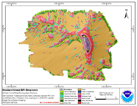 BPI Structures are derived from two scales of a focal mean
analysis on bathymetry and slope. The grid is based on
gridded (40 m cell size) multibeam bathymetry, collected aboard R/V AHI
and NOAA ship Hi'ialakai. BPI Structures was created using the Benth...
BPI Structures are derived from two scales of a focal mean
analysis on bathymetry and slope. The grid is based on
gridded (40 m cell size) multibeam bathymetry, collected aboard R/V AHI
and NOAA ship Hi'ialakai. BPI Structures was created using the Benth...
 BPI Zones are derived from gridded (40 m cell size) multibeam
bathymetry, collected aboard R/V AHI and NOAA ship Hi'ialakai.
BPI Zones was created using the Benthic Terrain Modeler (http://www.csc.noaa.gov/products/btm/).
Cell values represent one of 4 cl...
BPI Zones are derived from gridded (40 m cell size) multibeam
bathymetry, collected aboard R/V AHI and NOAA ship Hi'ialakai.
BPI Zones was created using the Benthic Terrain Modeler (http://www.csc.noaa.gov/products/btm/).
Cell values represent one of 4 cl...
 Rugosity is derived from gridded (40 m cell size) multibeam
bathymetry, collected aboard R/V AHI and NOAA ship Hi'ialakai.
Cell values reflect the (surface area) / (planimetric area)
ratio for the area contained within that cell's boundaries. They
provid...
Rugosity is derived from gridded (40 m cell size) multibeam
bathymetry, collected aboard R/V AHI and NOAA ship Hi'ialakai.
Cell values reflect the (surface area) / (planimetric area)
ratio for the area contained within that cell's boundaries. They
provid...
 Slope is derived from gridded (40 m cell size) multibeam
bathymetry, collected aboard R/V AHI, and NOAA ship Hi'ialakai.
Cell values reflect the maximum rate of change (in degrees) in
elevation between neighboring cells derived with the ArcGIS
Spatial Ana...
Slope is derived from gridded (40 m cell size) multibeam
bathymetry, collected aboard R/V AHI, and NOAA ship Hi'ialakai.
Cell values reflect the maximum rate of change (in degrees) in
elevation between neighboring cells derived with the ArcGIS
Spatial Ana...