2009 NOAA Ortho-rectified Near Infrared Mosaic of Georgia: Kings Bay and Fernandina Beach (NODC Accession 0092435)
This data set contains ortho-rectified mosaic tiles, created as a product from the NOAA Integrated Ocean and Coastal Mapping (IOCM) initiative. The source imagery was acquired from 20091104 - 20091104. The images were acquired with an Applanix Digital Se...
This data set contains ortho-rectified mosaic tiles, created as a product from the NOAA Integrated Ocean and Coastal Mapping (IOCM) initiative. The source imagery was acquired from 20091029 - 20091103. The images were acquired with an Applanix Digital Se...
2010 NOAA Ortho-rectified Mosaic of Savannah River, Georgia (NODC Accession 0092435)
This data set contains ortho-rectified mosaic tiles, created as a product from the NOAA Integrated Ocean and Coastal Mapping (IOCM) initiative. The source imagery was acquired from 20100307 - 20100307. The images were acquired with an Applanix Digital Se...
2009 NOAA Ortho-rectified Mosaic of Brunswick Georgia (NODC Accession 0092435)
This data set contains ortho-rectified mosaic tiles, created as a product from the NOAA Integrated Ocean and Coastal Mapping (IOCM) initiative. The source imagery was acquired from 20091029 - 20091103. The images were acquired with an Applanix Digital Se...
This data set contains ortho-rectified mosaic tiles, created as a product from the NOAA Integrated Ocean and Coastal Mapping (IOCM) initiative. The source imagery was acquired from 20091025 - 20091025. The images were acquired with an Applanix Digital Se...
2009 NOAA Ortho-rectified Mosaic of Georgia: Kings Bay and Fernandina Beach Integrated Ocean and Coastal Mapping Product (NODC Accession 0092435)
This data set contains ortho-rectified mosaic tiles, created as a product from the NOAA Integrated Ocean and Coastal Mapping (IOCM) initiative. The source imagery was acquired from 20091104 - 20091104. The images were acquired with an Applanix Digital Se...
2009 NOAA Ortho-rectified Infrared Mosaic of Georgia: Port of Savannah (NODC Accession 0092435)
This data set contains ortho-rectified mosaic tiles, created as a product from the NOAA Integrated Ocean and Coastal Mapping (IOCM) initiative. The source imagery was acquired from 20091025 - 20091025. The images were acquired with an Applanix Digital Se...
Rugosity 10 m grid derived from gridded bathymetry of Agrihan Island,
Commonwealth of the Northern Mariana Islands (CNMI), USA
Rugosity is derived from gridded (10 m cell size)
multibeam bathymetry, collected aboard NOAA Ship Hiialaka'i and
R/V AHI, using the Benthic Terrain Modeler with rugosity methods by
Jeff Jenness (2003). Cell values reflect the surface area to
planimetric ...
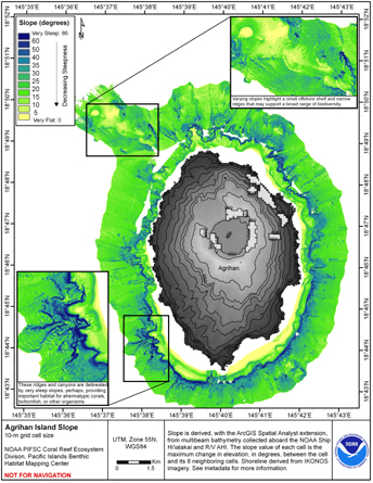
Slope 10 m grid derived from gridded bathymetry of Agrihan Island,
Commonwealth of the Northern Mariana Islands (CNMI), USA
Slope is derived from gridded (10 m cell size) multibeam
bathymetry, collected aboard NOAA Ship Hiialaka'i and R/V AHI.
Cell values reflect the maximum rate of change (in degrees) in
elevation between neighboring cells derived with the ArcGIS
Spatial Anal...
 2009 NOAA Ortho-rectified Near Infrared Mosaic of Georgia: Kings Bay and Fernandina Beach (NODC Accession 0092435)
 This map displays optical validation observation locations and percent coverage of scleractinian coral overlaid on bathymetry.
 Rugosity is derived from gridded (10 m cell size)
multibeam bathymetry, collected aboard NOAA Ship Hiialaka'i and
R/V AHI, using the Benthic Terrain Modeler with rugosity methods by
Jeff Jenness (2003). Cell values reflect the surface area to
planimetric ...
Rugosity is derived from gridded (10 m cell size)
multibeam bathymetry, collected aboard NOAA Ship Hiialaka'i and
R/V AHI, using the Benthic Terrain Modeler with rugosity methods by
Jeff Jenness (2003). Cell values reflect the surface area to
planimetric ...
 Slope is derived from gridded (10 m cell size) multibeam
bathymetry, collected aboard NOAA Ship Hiialaka'i and R/V AHI.
Cell values reflect the maximum rate of change (in degrees) in
elevation between neighboring cells derived with the ArcGIS
Spatial Anal...
Slope is derived from gridded (10 m cell size) multibeam
bathymetry, collected aboard NOAA Ship Hiialaka'i and R/V AHI.
Cell values reflect the maximum rate of change (in degrees) in
elevation between neighboring cells derived with the ArcGIS
Spatial Anal...