 CRED Simrad em3002d multibeam backscatter data from the banktop and bank edge environments at Tutuila, American Samoa, South Pacific with 1 meter resolution in netCDF format
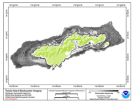 Multibeam backscatter imagery extracted from gridded bathymetry of Tutuila, American Samoa, South Pacific
These data provide coverage between 20 and 5000 meters. The backscatter dataset includes data collected using Simrad EM3002d and
Reson 8101 multibeam...
Multibeam backscatter imagery extracted from gridded bathymetry of Tutuila, American Samoa, South Pacific
These data provide coverage between 20 and 5000 meters. The backscatter dataset includes data collected using Simrad EM3002d and
Reson 8101 multibeam...
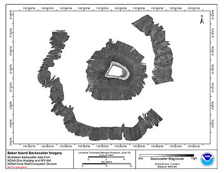 Multibeam backscatter imagery extracted from gridded bathymetry of the shelf and slope
environments of Baker Island, Pacific Island Areas, Central Pacific. These data provide coverage
between 8 and 4700 meters. The backscatter dataset includes data collec...
Multibeam backscatter imagery extracted from gridded bathymetry of the shelf and slope
environments of Baker Island, Pacific Island Areas, Central Pacific. These data provide coverage
between 8 and 4700 meters. The backscatter dataset includes data collec...
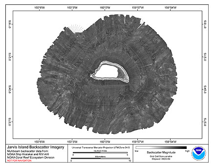 Multibeam backscatter imagery extracted from gridded bathymetry of the shelf and slope environments of Jarvis
Atoll, Pacific Island Areas, Central Pacific. These data provide coverage between 20 and 5000 meters. The backscatter dataset
includes data colle...
Multibeam backscatter imagery extracted from gridded bathymetry of the shelf and slope environments of Jarvis
Atoll, Pacific Island Areas, Central Pacific. These data provide coverage between 20 and 5000 meters. The backscatter dataset
includes data colle...