 Mosaic of bathymetry derived from multispectral WV-2
satellite imagery of Agrihan Island, Territory of Mariana, USA (NODC Accession 0126914)
Mosaic of bathymetry derived from multispectral WV-2
satellite imagery of Agrihan Island, Territory of Mariana, USA (NODC Accession 0126914)
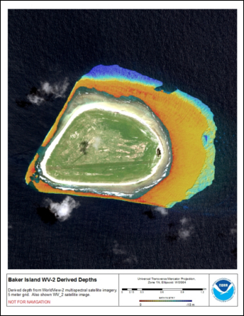
 Bathymetric data derived from a multispectral World View-2 satellite
image mosaiced to provide near complete coverage of nearshore
terrain around the islands. Bathymetry values shallower than ~20 m were
derived by gauging the relative attenuation of coast...
Bathymetric data derived from a multispectral World View-2 satellite
image mosaiced to provide near complete coverage of nearshore
terrain around the islands. Bathymetry values shallower than ~20 m were
derived by gauging the relative attenuation of coast...
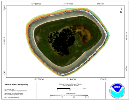
 Bathymetric data derived from a multipectral World View-2 satellite
image mosaiced to provide near complete coverage of nearshore
terrain around the islands. Bathymetry values shallower than ~20 m were
derived by gauging the reletive attenuation of coasta...
Bathymetric data derived from a multipectral World View-2 satellite
image mosaiced to provide near complete coverage of nearshore
terrain around the islands. Bathymetry values shallower than ~20 m were
derived by gauging the reletive attenuation of coasta...
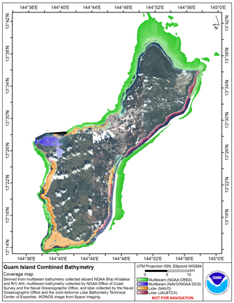 Gridded multibeam bathymetry is integrated with gridded lidar bathymetry.
Gridded (5 m cell size) multibeam bathymetry were collected aboard NOAA Ship
Hiialaka'i and R/V AHI and by the Naval Oceanographic Office and NOAA
Office of Coast Survey in Apra Har...
Gridded multibeam bathymetry is integrated with gridded lidar bathymetry.
Gridded (5 m cell size) multibeam bathymetry were collected aboard NOAA Ship
Hiialaka'i and R/V AHI and by the Naval Oceanographic Office and NOAA
Office of Coast Survey in Apra Har...
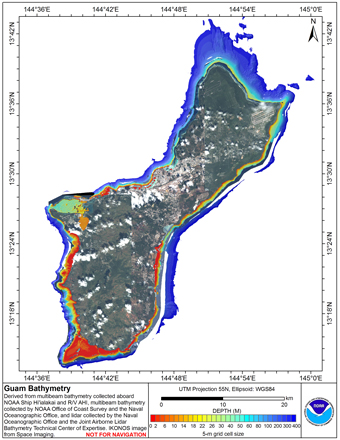
 Gridded multibeam bathymetry is integrated with bathymetry
derived from multispectral IKONOS satellite data. Gridded (5 m cell
size) multibeam bathymetry collected aboard NOAA Ship Hiialaka'i and
R/V AHI. Bathymetry values shallower than 25 m were derived...
Gridded multibeam bathymetry is integrated with bathymetry
derived from multispectral IKONOS satellite data. Gridded (5 m cell
size) multibeam bathymetry collected aboard NOAA Ship Hiialaka'i and
R/V AHI. Bathymetry values shallower than 25 m were derived...
 Gridded multibeam bathymetry is integrated with bathymetry
derived from multpectral IKONOS satellite data. Gridded (5m and 10 m cell
size) multibeam bathymetry collected aboard NOAA Ship Hiialaka'i and
R/V AHI. Bathymetry values shallower than 25 m were d...
Gridded multibeam bathymetry is integrated with bathymetry
derived from multpectral IKONOS satellite data. Gridded (5m and 10 m cell
size) multibeam bathymetry collected aboard NOAA Ship Hiialaka'i and
R/V AHI. Bathymetry values shallower than 25 m were d...