CRED Optical Validation Data collected on Galvez Bank, Territory of Guam; and Rota Island, Commonwealth of Northern
Mariana Islands, USA, in 2010 to support Benthic Habitat Mapping
Optical validation data were collected using a SeaBED-class AUV, over Galvez Bank, Territory of Guam; and Rota Island,
Commonwealth of Northern Mariana Islands, USA. Data were collected from the NOAA Ship the Oscar Elton Sette during cruise SE1002,
which ...
CRED Optical Validation Data in the Auau Channel, Hawaii, February 2009 to Support Benthic Habitat Mapping
Optical validation data were collected using a RCV-150 remotely operated vehicle (ROV) operated by the Hawaii Undersea
Research Laboratory (HURL). Data were collected in the Auau Channel, Main Hawaiian Islands, to support benthic habitat mapping
efforts d...
CRED Optical Validation Data in the Auau Channel, Hawaii, April 2009 to Support Benthic Habitat Mapping
Optical validation data were collected using a RCV-150 remotely operated vehicle (ROV) operated by the Hawaii Undersea
Research Laboratory (HURL). Data were collected in the Auau Channel, Main Hawaiian Islands, to support benthic habitat mapping
efforts d...
CRED Optical Validation Data in the Auau Channel, Hawaii, 2007, to Support Benthic Habitat Mapping
Optical validation data were collected using a RCV-150 remotely operated vehicle (ROV) operated by the Hawaii Undersea
Research Laboratory (HURL). Data were collected in the Auau Channel, Main Hawaiian Islands, to support benthic habitat mapping
efforts d...
CRED Optical Validation Data in the Auau Channel, Hawaii, 2009 to Support Benthic Habitat Mapping
Optical validation data were collected using a Tethered Optical Assessment Device (TOAD), an underwater sled
equipped with an underwater digital video camera and lights. Data were collected at the Main Hawaiian Islands, in the Auau Channel, Maui
to suppo...
CRED Optical Validation Data in the Auau Channel, Hawaii, 2008 to
Support Benthic Habitat Mapping
Optical validation data were collected using a
Tethered Optical Assessment Device (TOAD), an underwater sled equipped
with an underwater digital video camera and lights. Data were collected
at the Main Hawaiian Islands, in the Auau Channel, Maui to suppo...
Rugosity grid derived from gridded bathymetry of of Galvez Bank, South Galvez Bank, and 11-Mile Reef, Territory of Guam, USA.
Rugosity is derived from gridded (5 m cell size) multibeam bathymetry, aboard NOAA Ship Oscar Elton Sette. Cell values reflect the (surface area) / (planimetric area) ratio for the area contained within that cell's boundaries. They provide indices o...
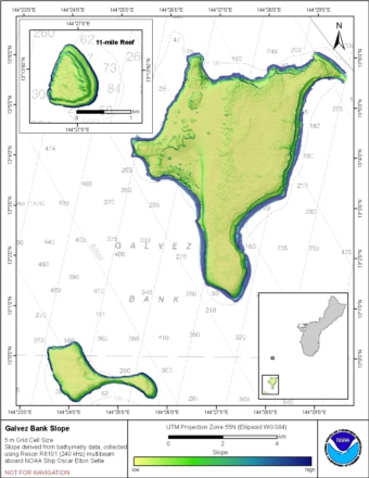
Slope grid derived from gridded bathymetry of Galvez Bank, South Galvez Bank, and 11-Mile Reef,
Territory of Guam, USA.
Slope is derived from gridded (5 m cell size) multibeam
bathymetry, collected aboard NOAA Ship Oscar Elton Sette.
Cell values reflect the maximum rate of change (in degrees) in
elevation between neighboring cells derived with the ArcGIS
Spatial Analyst ex...
Bathymetric Position Index (BPI) Zones 5 m grid derived from gridded
bathymetry of Kure Atoll, Hawaii, USA.
BPI Zones are derived from a focal mean analysis on
bathymetry and slope. The grid is based on gridded (5 m cell size)
multibeam bathymetry, collected aboard R/V AHI, merged with seafloor
depths derived from IKONOS satellite imagery. BPI Zones
was was cre...
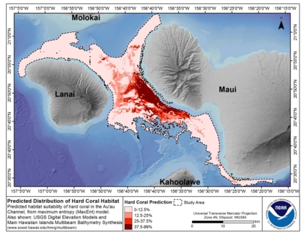
Predicted Habitat Suitability for All Mesophotic Corals in the Au'au Channel Region
This dataset is located between the islands of Maui, Lanai, Molokai and Kahoolawe, and includes
the Au'au Channel as well as parts of the Kealaikahiki, Alalakeiki and Kalohi Channels.
This map denotes predicted habitat suitability for all mesophotic coral...
 CRED Optical Validation Data collected on Galvez Bank, Territory of Guam; and Rota Island, Commonwealth of Northern
Mariana Islands, USA, in 2010 to support Benthic Habitat Mapping
CRED Optical Validation Data collected on Galvez Bank, Territory of Guam; and Rota Island, Commonwealth of Northern
Mariana Islands, USA, in 2010 to support Benthic Habitat Mapping
 Rugosity grid derived from gridded bathymetry of of Galvez Bank, South Galvez Bank, and 11-Mile Reef, Territory of Guam, USA.
 Rugosity is derived from gridded (5 m cell size) multibeam bathymetry, aboard NOAA Ship Oscar Elton Sette. Cell values reflect the (surface area) / (planimetric area) ratio for the area contained within that cell's boundaries. They provide indices o...
 Slope is derived from gridded (5 m cell size) multibeam
bathymetry, collected aboard NOAA Ship Oscar Elton Sette.
Cell values reflect the maximum rate of change (in degrees) in
elevation between neighboring cells derived with the ArcGIS
Spatial Analyst ex...
Slope is derived from gridded (5 m cell size) multibeam
bathymetry, collected aboard NOAA Ship Oscar Elton Sette.
Cell values reflect the maximum rate of change (in degrees) in
elevation between neighboring cells derived with the ArcGIS
Spatial Analyst ex...
 BPI Zones are derived from a focal mean analysis on
bathymetry and slope. The grid is based on gridded (5 m cell size)
multibeam bathymetry, collected aboard R/V AHI, merged with seafloor
depths derived from IKONOS satellite imagery. BPI Zones
was was cre...
BPI Zones are derived from a focal mean analysis on
bathymetry and slope. The grid is based on gridded (5 m cell size)
multibeam bathymetry, collected aboard R/V AHI, merged with seafloor
depths derived from IKONOS satellite imagery. BPI Zones
was was cre...
 This dataset is located between the islands of Maui, Lanai, Molokai and Kahoolawe, and includes
the Au'au Channel as well as parts of the Kealaikahiki, Alalakeiki and Kalohi Channels.
This map denotes predicted habitat suitability for all mesophotic coral...
This dataset is located between the islands of Maui, Lanai, Molokai and Kahoolawe, and includes
the Au'au Channel as well as parts of the Kealaikahiki, Alalakeiki and Kalohi Channels.
This map denotes predicted habitat suitability for all mesophotic coral...