 Bathymetric Bathymetric Position Index (BPI) Zones 20 m grid derived from gridded
bathymetry of Baker Island, Pacific Remote Island Areas, Central Pacific.
Bathymetric Bathymetric Position Index (BPI) Zones 20 m grid derived from gridded
bathymetry of Baker Island, Pacific Remote Island Areas, Central Pacific.
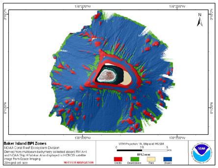 BPI Zones are derived from gridded (20 m cell size) multibeam
bathymetry, collected aboard R/V AHI and NOAA ship Hi'ialakai.
BPI Zones was created using the Benthic Terrain Modeler (http://www.csc.noaa.gov/products/btm/).
Cell values represent one of 4 cl...
BPI Zones are derived from gridded (20 m cell size) multibeam
bathymetry, collected aboard R/V AHI and NOAA ship Hi'ialakai.
BPI Zones was created using the Benthic Terrain Modeler (http://www.csc.noaa.gov/products/btm/).
Cell values represent one of 4 cl...
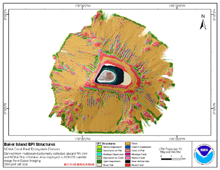 BPI Structures are derived from two scales of a focal mean
analysis on bathymetry and slope. The grid is based on
gridded (20 m cell size) multibeam bathymetry, collected aboard R/V AHI
and NOAA ship Hi'ialakai. BPI Structures was created using the Benth...
BPI Structures are derived from two scales of a focal mean
analysis on bathymetry and slope. The grid is based on
gridded (20 m cell size) multibeam bathymetry, collected aboard R/V AHI
and NOAA ship Hi'ialakai. BPI Structures was created using the Benth...
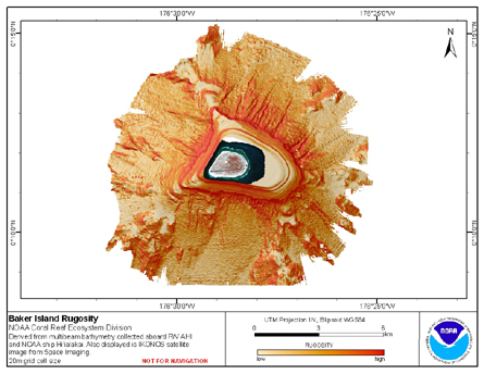 Rugosity is derived from gridded (20 m cell size) multibeam
bathymetry, collected aboard R/V AHI and NOAA ship Hi'ialakai.
Cell values reflect the (surface area) / (planimetric area)
ratio for the area contained within that cell's boundaries. They
provid...
Rugosity is derived from gridded (20 m cell size) multibeam
bathymetry, collected aboard R/V AHI and NOAA ship Hi'ialakai.
Cell values reflect the (surface area) / (planimetric area)
ratio for the area contained within that cell's boundaries. They
provid...
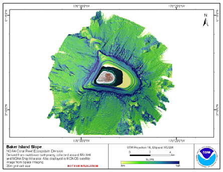 Slope is derived from gridded (20 m cell size) multibeam
bathymetry, collected aboard R/V AHI, and NOAA ship Hi'ialakai.
Cell values reflect the maximum rate of change (in degrees) in
elevation between neighboring cells derived with the ArcGIS
Spatial Ana...
Slope is derived from gridded (20 m cell size) multibeam
bathymetry, collected aboard R/V AHI, and NOAA ship Hi'ialakai.
Cell values reflect the maximum rate of change (in degrees) in
elevation between neighboring cells derived with the ArcGIS
Spatial Ana...
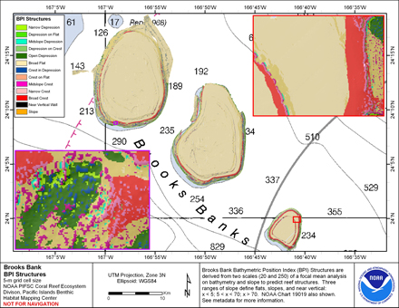 BPI Structures are derived from two scales of a focal mean
analysis on bathymetry and slope. The grid is based on
gridded (5 m cell size) multibeam bathymetry, collected aboard NOAA ship Hi'ialakai
and R/V AHI. It was created using the Benthic
Terrain Mo...
BPI Structures are derived from two scales of a focal mean
analysis on bathymetry and slope. The grid is based on
gridded (5 m cell size) multibeam bathymetry, collected aboard NOAA ship Hi'ialakai
and R/V AHI. It was created using the Benthic
Terrain Mo...
 BPI Zones are derived from a focal mean analysis on
bathymetry and slope. The grid is based on
gridded (5 m cell size) multibeam bathymetry, collected aboard NOAA ship
Hi'ialakai and R/V AHI. It was created using the Benthic
Terrain Modeler (http://www.cs...
BPI Zones are derived from a focal mean analysis on
bathymetry and slope. The grid is based on
gridded (5 m cell size) multibeam bathymetry, collected aboard NOAA ship
Hi'ialakai and R/V AHI. It was created using the Benthic
Terrain Modeler (http://www.cs...
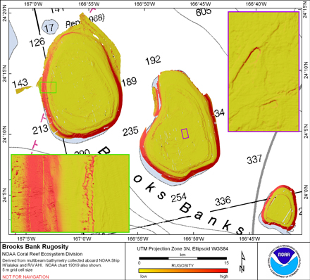 Rugosity is derived from gridded (5 m cell size)
multibeam bathymetry, collected aboard NOAA ship Hi'ialakai and R/V AHI using the
Benthic Terrain Modeler with rugosity methods by Jeff Jenness (2003).
Cell values reflect the (surface area) / (planimetric ...
Rugosity is derived from gridded (5 m cell size)
multibeam bathymetry, collected aboard NOAA ship Hi'ialakai and R/V AHI using the
Benthic Terrain Modeler with rugosity methods by Jeff Jenness (2003).
Cell values reflect the (surface area) / (planimetric ...
 Slope is derived from gridded (5 m cell size) multibeam
bathymetry, collected aboard NOAA ship Hi'ialakai and R/V AHI.
Cell values reflect the maximum rate of change (in degrees) in
elevation between neighboring cells derived with the ArcGIS
Spatial Analy...
Slope is derived from gridded (5 m cell size) multibeam
bathymetry, collected aboard NOAA ship Hi'ialakai and R/V AHI.
Cell values reflect the maximum rate of change (in degrees) in
elevation between neighboring cells derived with the ArcGIS
Spatial Analy...
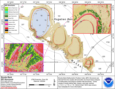 BPI Structures are derived from two scales of a focal mean
analysis on bathymetry and slope. The grid is based on
gridded (20 m cell size) multibeam bathymetry, collected aboard NOAA ship Hi'ialakai
and R/V AHI. It was created using the Benthic
Terrain M...
BPI Structures are derived from two scales of a focal mean
analysis on bathymetry and slope. The grid is based on
gridded (20 m cell size) multibeam bathymetry, collected aboard NOAA ship Hi'ialakai
and R/V AHI. It was created using the Benthic
Terrain M...
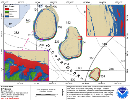
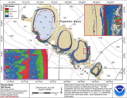 BPI Zones are derived from a focal mean analysis on
bathymetry and slope. The grid is based on
gridded (20 m cell size) multibeam bathymetry, collected aboard NOAA ship Hi'ialakai
and R/V AHI. It was created using the Benthic
Terrain Modeler (http://www.c...
BPI Zones are derived from a focal mean analysis on
bathymetry and slope. The grid is based on
gridded (20 m cell size) multibeam bathymetry, collected aboard NOAA ship Hi'ialakai
and R/V AHI. It was created using the Benthic
Terrain Modeler (http://www.c...