 CRED REA Fish Team Stationary Point Count Surveys at Hawaii Island, 2005
Stationary Point Counts at 4 stations at each survey site were surveyed as
part of Rapid Ecological Assessments conducted at 19 sites at Hawaii in
February and March, 2005 from the NOAA vessel Oscar Elton Sette (OES05-02).
Raw survey data included species...
 American Samoa: coral reef monitoring interactive map and information layers primarily from 2010 surveys
 This interactive map displays American Samoa data collected by the NOAA Coral Reef Ecosystem Division (CRED) during the Pacific Reef Assessment and Monitoring Program (RAMP) cruises. The information presented is a combination of standard CRED monitoring s...
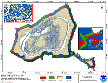
 BPI Zones are derived from a focal mean analysis on
bathymetry and slope. The grid is based on gridded (5 m cell size)
multibeam bathymetry, collected aboard R/V AHI, merged with seafloor
depths derived from IKONOS satellite imagery. BPI Zones
was was cre...
BPI Zones are derived from a focal mean analysis on
bathymetry and slope. The grid is based on gridded (5 m cell size)
multibeam bathymetry, collected aboard R/V AHI, merged with seafloor
depths derived from IKONOS satellite imagery. BPI Zones
was was cre...