2002 Status of coral reefs on the main volcanic islands of American Samoa: a resurvey of long term monitoring sites including benthic communities, fish communities, and key macroinvertebrates (NODC Accession 0001973)
This study demonstrates the important role that long term monitoring programs can play in understanding the natural variability and long term trends in the coral reefs of American Samoa. One benefit of this study is that it provides an overview of the co...
2002 Status of coral reefs on the main volcanic islands of American Samoa: a resurvey of long term monitoring sites including benthic communities, fish communities, and key macroinvertebrates (NODC Accession 0001976)
This study demonstrates the important role that long term monitoring programs
can play in understanding the natural variability and long term trends in the
coral reefs of American Samoa. One benefit of this study is that it provides
an overview of the co...
Status of Coral Communities in American Samoa: A Re-survey of Long-term Monitoring Sites in 2002 (NODC Accession 0001470)
This data set consists of an MS Word file which documents and summarizes data previously submitted as MS Excel spreadsheets to the NOAA data centers, NODC ACCESSION 0000735. The present MS Word file contains some data not found in the spreadsheets and thi...
Oculina Banks Bathymetry 2002 from Multi-beam and Sidescan Sonar Surveys (NODC Accession 0090252)
These data are the result of a multi-beam echosounder survey conducted in the OHAPC by the M/V Liberty Star in October 2002.
Two forms of data are available: 1) geotifs available through the on-line OGIS (www.uncw.edu/oculina) on the OGIS CD, and from CoR...
NCCOS Assessment: Fish and benthic communities in the East End Marine Park, St. Croix, U.S. Virgin Islands from 2022-04-25 to 2022-06-18 (NCEI Accession 0290374)
This dataset includes fish count and benthic cover data collected at 138 sites during 2022 in East End Marine Park (EEMP), St. Croix, U.S. Virgin Islands. Fish were counted, identified to species, and sized along a transect (Menza et al. 2006, Pittman et ...
Assessment of Species Composition, Diversity, and Biomass in Marine Habitats
and Subhabitats around Offshore Islets in the Main Hawaiian Islands 2007 (NODC Accession 0042684)
The marine algae, invertebrate and fish communities were surveyed at ten islet
or offshore island sites in the Main Hawaiian Islands in the vicinity of
Lanai, (Puu Pehe and Poo Poo Islets), Maui (Kaemi and Hulu
Islets and the outer rim of Molokini), off K...
Photographic Images of Benthic Coral, Algae, and Invertebrate Species in Marine Habitats and Subhabitats around Offshore Islets in the Main Hawaiian Islands 2007 (NODC Accession 0043046)
The marine algae, invertebrate and fish communities were surveyed at ten islet
or offshore island sites in the Main Hawaiian Islands in the vicinity of
Lanai, (Puu Pehe and Poo Poo Islets), Maui (Kaemi and Hulu
Islets and the outer rim of Molokini), off K...
Coastal turbidity on the Southeast Florida Shelf - Monitoring turbid water sources and fates by satellite in the Port Everglades region of interest from 2002-07-04 to 2018-03-21 (NCEI Accession 0173406)
This dataset includes relative turbidity data and environmental correlates (modeled wave height) for the Southeast Florida shelf - from 2002 to 2018 - Port Everglades region of interest (PVGF1). Data are in gridded netCDF binary format - Hierarchical Data...
Coastal turbidity on the Southeast Florida Shelf - Monitoring turbid water sources and fates by satellite in the Palm Beach renourishment project region of interest (SECREMP_PB2) from 2002-07-04 to 2018-03-21 (NCEI Accession 0173407)
This dataset contains relative turbidity data and environmental correlates (modeled wave height) for the Southeast Florida Shelf from 2002 to 2018 in the Palm Beach renourishment project region of interest (SECREMP_PB2). These data are in gridded netCDF b...
 2002 Status of coral reefs on the main volcanic islands of American Samoa: a resurvey of long term monitoring sites including benthic communities, fish communities, and key macroinvertebrates (NODC Accession 0001973)
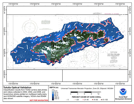 This map displays optical validation observation locations and percent coverage of hard coral overlaid on bathymetry.
 Assessment of Species Composition, Diversity, and Biomass in Marine Habitats
and Subhabitats around Offshore Islets in the Main Hawaiian Islands 2007 (NODC Accession 0042684)
Assessment of Species Composition, Diversity, and Biomass in Marine Habitats
and Subhabitats around Offshore Islets in the Main Hawaiian Islands 2007 (NODC Accession 0042684)