Summer 2004 Coral Bleaching Event on Tutuila, American Samoa (NODC Accession 0001955)
American Samoa's coral reefs have been impacted by a variety of major events, including periodic severe hurricanes, the most recent of which was Hurricane Heta, which was closest on Jan 6, 2004. Other events have included a Crown-of-Thorns seastar outbrea...
2007 MrSID Image of St. John Utilized to derive Benthic Habitat Maps (18064_c6_ne.sid)
This MrSID (.sid) file is an orthophoto mosaic from a collection of GeoTIFF format natural color and false color infrared orthophotos covering the islands of Puerto Rico, Culebra, Vieques, St. Thomas, St. John, and St. Croix (USVI). An orthophoto is remo...
2007 MrSID Image of St. John Utilized to derive Benthic Habitat Maps (18064_c6_nw.sid)
This MrSID (.sid) file is an orthophoto mosaic from a collection of GeoTIFF format natural color and false color infrared orthophotos covering the islands of Puerto Rico, Culebra, Vieques, St. Thomas, St. John, and St. Croix (USVI). An orthophoto is remo...
2007 MrSID Image of St. John Utilized to derive Benthic Habitat Maps (18064_c6_sw.sid)
This MrSID (.sid) file is an orthophoto mosaic from a collection of GeoTIFF format natural color and false color infrared orthophotos covering the islands of Puerto Rico, Culebra, Vieques, St. Thomas, St. John, and St. Croix (USVI). An orthophoto is remo...
2007 MrSID Image of St. John Utilized to derive Benthic Habitat Maps (18064_c7_ne.sid)
This MrSID (.sid) file is an orthophoto mosaic from a collection of GeoTIFF format natural color and false color infrared orthophotos covering the islands of Puerto Rico, Culebra, Vieques, St. Thomas, St. John, and St. Croix (USVI). An orthophoto is remo...
2007 MrSID Image of St. John Utilized to derive Benthic Habitat Maps (18064_c7_nw.sid)
This MrSID (.sid) file is an orthophoto mosaic from a collection of GeoTIFF format natural color and false color infrared orthophotos covering the islands of Puerto Rico, Culebra, Vieques, St. Thomas, St. John, and St. Croix (USVI). An orthophoto is remo...
2007 MrSID Image of St. John Utilized to derive Benthic Habitat Maps (18064_c7_se.sid)
This MrSID (.sid) file is an orthophoto mosaic from a collection of GeoTIFF format natural color and false color infrared orthophotos covering the islands of Puerto Rico, Culebra, Vieques, St. Thomas, St. John, and St. Croix (USVI). An orthophoto is remo...
Benthic Habitat Maps for Rose Atoll Marine National Monument in American Samoa from 2004 to 2010
Benthic habitat maps for Rose Atoll, American Samoa were derived from high resolution, multispectral satellite imagery for 2004, 2006, and 2010. The benthic habitat maps for 2004 were previously generated by NOAA's NCCOS's BioGeography Branch before this ...
2012-2013 U.S. Geological Survey LiDAR: Territory of Guam
Territory of Guam, LiDAR Task G11PD01189
This task order is for production of surface model products of The Territory of Guam. The models are produced from data acquired using airborne Light Detection and Ranging (LiDAR) sensors. The data is calibrated, ...
 Summer 2004 Coral Bleaching Event on Tutuila, American Samoa (NODC Accession 0001955)
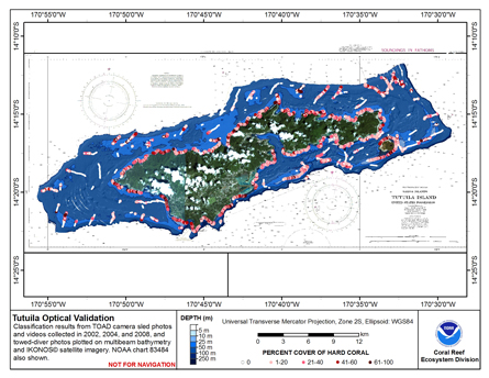 This map displays optical validation observation locations and percent coverage of hard coral overlaid on bathymetry.
 Territory of Guam, LiDAR Task G11PD01189
This task order is for production of surface model products of The Territory of Guam. The models are produced from data acquired using airborne Light Detection and Ranging (LiDAR) sensors. The data is calibrated, ...
Territory of Guam, LiDAR Task G11PD01189
This task order is for production of surface model products of The Territory of Guam. The models are produced from data acquired using airborne Light Detection and Ranging (LiDAR) sensors. The data is calibrated, ...