Mesophotic (30-60m) fishery-independent survey in St. Thomas and St. John, U.S. Virgin Islands from 2018-08-02 to 2022-12-16 (NCEI Accession 0276998)
This project employed specialized technical SCUBA diving methods to provide the first assessment of population dynamics and habitat-related life history of reef fishes on the mesophotic reef habitat in St. Thomas and St. John, U.S. Virgin Islands that can...
NOAA ESRI Geotiff - 3m Backscatter Mosaic, Puerto Rico (Isla de Vieques) - UTM 20N NAD83 (NCEI Accession 0131852)
This image represents a 3 meter resolution backscatter mosaic of selected portions of seafloor around Isla de Vieques, Puerto Rico. NOAA's NOS/NCCOS/CCFHR, in collaboration with NOAA vessel Nancy Foster and territory, federal, and private sector partners,...
NOAA ESRI Geotiff - 3m Multibeam Bathymetry, Puerto Rico (Isla de Vieques) - UTM 20N NAD83 (NCEI Accession 0131852)
This dataset contains an ESRI Geotiff with 3 meter cell size representing the bathymetry of a selected portion of seafloor south of Isla de Vieques in Puerto Rico, derived from data collected in 2008. NOAA's NOS/NCCOS/CCFHR, in collaboration with NOAA ves...
NOAA ESRI Grid - NOAA ESRI GRID - 3 m Backscatter Mosaic of Mona Island, Puerto Rico, Project NF-08-04, UTM 19N NAD83
This image represents a 3 meter resolution backscatter mosaic of selected portions of seafloor around Mona Island, Puerto Rico. NOAA's NOS/NCCOS/CCMA Biogeography Branch, in collaboration with NOAA vessel Nancy Foster and territory, federal, and private s...
NOAA ESRI Grid - 3m Multibeam Bathymetry, Puerto Rico (Isla de Mona) - Project NF-08-04, , UTM 19N NAD83
This dataset contains an ESRI Grid with 3 meter cell size representing the bathymetry of selected portions of seafloor around Isla de Mona in Puerto Rico, derived from data collected in 2008.
NOAA's NOS/NCCOS/CCMA Biogeography Branch, in collaboration wi...
NOAA ESRI Grid - 6m Multibeam Bathymetry, Puerto Rico (Isla de Mona) - Project NF-08-04, , UTM 19N NAD83
This dataset contains an ESRI Grid with 6 meter cell size representing the bathymetry of selected portions of seafloor around Isla de Mona in Puerto Rico, derived from data collected in 2008.
NOAA's NOS/NCCOS/CCMA Biogeography Branch, in collaboration wi...
NOAA ESRI Grid - 9m Multibeam Bathymetry, Puerto Rico (Isla de Mona) - Project NF-08-04, UTM 19N NAD83
This dataset contains an ESRI Grid with 9 meter cell size representing the bathymetry of selected portions of seafloor around Isla de Mona in Puerto Rico, derived from data collected in 2008.
NOAA's NOS/NCCOS/CCMA Biogeography Branch, in collaboration wi...
NOAA ESRI Grid - NOAA ESRI GRID - 3 m Backscatter Mosaic of Tourmaline Bank, Puerto Rico, Project NF-08-04, UTM 19N NAD83
This image represents a 3 meter resolution backscatter mosaic of selected portions of seafloor around Tourmaline Bank, Puerto Rico. NOAA's NOS/NCCOS/CCMA Biogeography Branch, in collaboration with NOAA vessel Nancy Foster and territory, federal, and priva...
This dataset contains an ESRI Grid with 3 meter cell size representing the bathymetry of selected portions of seafloor around Tourmaline Bank in Puerto Rico, derived from data collected in 2008.
NOAA's NOS/NCCOS/CCMA Biogeography Branch, in collaboration...
 CRED Map of Percent Hard Coral Cover at Tutuila Island, American Samoa
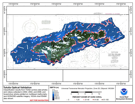 This map displays optical validation observation locations and percent coverage of hard coral overlaid on bathymetry.