
CRED Reson 8101ER Multibeam Sonar Data from Cruise AHI0804 - Northwestern Hawaiian Islands, 2008
Reson 8101ER multibeam Data were collected between
2 - 29 May 2008 aboard NOAA Survey Launch Acoustic
Habitat Investigator (AHI) at French Frigate Shoals in the
Papahanaumokuakea Marine National Monument during cruise
AHI0804. These multibeam data were c...
CRED EM300 and EM3002D Multibeam Sonar Data from Cruise Hi'ialakai hi0804 - Northwestern Hawaiian Islands, 2008
EM300 and EM3002D multibeam Data were collected from
2 - 29 May 2008 aboard NOAA Ship Hi'ialakai at
Necker Island, French Frigate Shoals, and Brooks Bank in the
Northwestern Hawaiian Islands, during cruise hi0804.
These multibeam data were collected using...
 CRED 5 m Gridded bathymetry of Baker Island, Pacific Remote Island Areas, Central Pacific (Arc ASCII Format)
 Gridded (5 m cell size) bathymetry of the shelf and slope environments
of Baker Island, Pacific Remote Isand Areas, Central Pacific.
Almost complete bottom coverage was achieved in depths between
8 and 4700 meters (5 m grid includes data to 300 m). The ba...
Gridded (5 m cell size) bathymetry of the shelf and slope environments
of Baker Island, Pacific Remote Isand Areas, Central Pacific.
Almost complete bottom coverage was achieved in depths between
8 and 4700 meters (5 m grid includes data to 300 m). The ba...
 Gridded (5 m cell size) bathymetry of the shelf and slope environments
of Howland Island, Pacific Remote Island Areas, Central Pacific.
Almost complete bottom coverage was achieved in depths between 8 and
3800 meters (5 m grid includes depths to 300 m). T...
Gridded (5 m cell size) bathymetry of the shelf and slope environments
of Howland Island, Pacific Remote Island Areas, Central Pacific.
Almost complete bottom coverage was achieved in depths between 8 and
3800 meters (5 m grid includes depths to 300 m). T...
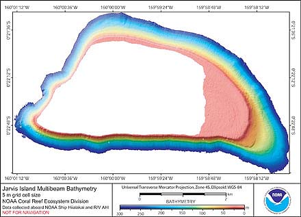 Gridded (5 m cell size) bathymetry of the shelf and slope environments
of Jarvis Island, Pacific Remote Island Areas, Central Pacific.
Almost complete bottom coverage was achieved in depths between
3 and 3600 meters (5 m grid includes data to 300 m). The ...
Gridded (5 m cell size) bathymetry of the shelf and slope environments
of Jarvis Island, Pacific Remote Island Areas, Central Pacific.
Almost complete bottom coverage was achieved in depths between
3 and 3600 meters (5 m grid includes data to 300 m). The ...
 Gridded (20 m cell size) bathymetry of the shelf and slope
environments of Jarvis Island, Pacific Remote Island Areas, Central Pacific.
Almost complete bottom coverage was achieved in depths between
3 and 3600 meters. The bathymetry dataset includes Simra...
Gridded (20 m cell size) bathymetry of the shelf and slope
environments of Jarvis Island, Pacific Remote Island Areas, Central Pacific.
Almost complete bottom coverage was achieved in depths between
3 and 3600 meters. The bathymetry dataset includes Simra...