Octocoral Density for the Florida Keys National Marine Sanctuary from 1999-2009. (NODC Accession 0123059)
Using data collected from 1999 to 2009, the dataset includes species density of benthic octocorals collected from multiple habitat types across the south Florida shelf, inside and outside of the no-take management zones, and throughout the Florida Keys fr...
Octocoral Species Richness for the Florida Keys National Marine Sanctuary from 1999-2009 (NODC Accession 0123059)
The dataset includes species richness of benthic branching and encrusting gorgonians collected from multiple habitat types across the south Florida shelf, inside and outside of the no-take management zones, and throughout the Florida Keys from south of Mi...
Geodatabase of fish assemblages for the Florida Coral Reef Tract from 1980-01-01 to 2010-12-31 (NODC Accession 0125569)
This dataset is a point shapefile showing the distribution of species richness, Shannon's Diversity (H), and Shannon's Evennes (J) along the Florida Keys (Key Biscayne to Key West based on data collected from 1980 through 2010. Point estimates of species ...
NOAA TIFF Image - 8m Backscatter Mosaic, W00221-222 USVI 2012, Seafloor Characterization of the US Caribbean - Nancy Foster - M-I907-NF-12 (2012), UTM 20N NAD83 (NCEI Accession 0131856)
This image represents a 8 meter resolution backscatter mosaic of of a sharply sloping swath of the St. John Shelf, south of NE Reserve, offshore of Fajardo, Puerto Rico. NOAA's NOS/NCCOS/CCMA Biogeography Team, in collaboration with NOAA vessel Nancy Fost...
NOAA TIFF Image - 2m Backscatter Mosaic, W00217 USVI 2011, Seafloor Characterization of the US Caribbean - Nancy Foster - NF-11-1 (2011), UTM 20N NAD83 (NCEI Accession 0131858)
This image represents a 2 meter resolution backscatter mosaic of a broad bank south of St. Thomas, US Virgin Islands. NOAA's NOS/NCCOS/CCMA Biogeography Team, in collaboration with NOAA vessel Nancy Foster and territory, federal, and private sector partne...
NOAA TIFF Image - 2m Backscatter Mosaic, W00216 USVI 2011, Seafloor Characterization of the US Caribbean - Nancy Foster - NF-11-1 (2011), UTM 20N NAD83 (NCEI Accession 0131858)
This image represents a 2 meter resolution backscatter mosaic of the bathymetry of a sharply sloping swath of the St. John Shelf, St. John, USVI. NOAA's NOS/NCCOS/CCMA Biogeography Team, in collaboration with NOAA vessel Nancy Foster and territory, federa...
NOAA TIFF Image - 4m Backscatter Mosaic , W00216 USVI 2011 , Seafloor Characterization of the US Caribbean - Nancy Foster - NF-11-1 (2011), UTM 20N NAD83 (NCEI Accession 0131858)
This image represents a 4 meter resolution backscatter mosaic of of a sharply sloping swath of the St. John Shelf, south of St. John, US Virgin Islands. NOAA's NOS/NCCOS/CCMA Biogeography Team, in collaboration with NOAA vessel Nancy Foster and territory,...
NOAA TIFF Image - 8m Multibeam Bathymetry , W00216 USVI 2011 , Seafloor Characterization of the US Caribbean - Nancy Foster - NF-11-1 (2011), UTM 20N NAD83 (NCEI Accession 0131858)
This dataset contains a GeoTIFF with 8x8 meter cell size representing the bathymetry of a sharply sloping swath of the St. John Shelf, a selected portion of seafloor south of St. John, USVI, derived from data collected from 3/28/2011 to 4/14/2011. NOAA's ...
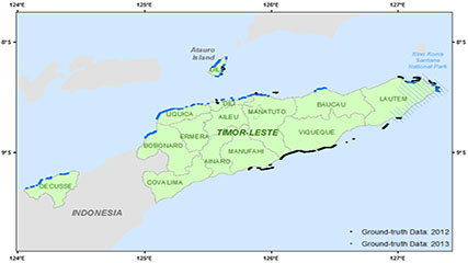
Depth soundings from a single beam echo sounder collected around the nearshore areas of Timor-Leste in 2012 and 2013
This dataset contains singlebeam bathymetry data acquired during small-boat surveys conducted from October 20-26, 2012 and June 4-27, 2013 in Timor-Leste by the NOAA Coral Reef Ecosystem Program (CREP). Data was acquired with a HydroLite-TM Echosounder Ki...
Benthic percent cover derived from analysis of benthic images collected at coral reef sites in Timor-Leste in 2013 and 2014 (NCEI Accession 0168620)
The benthic cover data described here result from benthic photo-quadrat surveys conducted by the NOAA Coral Reef Ecosystem Program (CREP) in hard bottom shallow water (< 15 m) habitats in Timor-Leste during reef fish surveys surveys at 150 sites that were...
 Octocoral Density for the Florida Keys National Marine Sanctuary from 1999-2009. (NODC Accession 0123059)
 NOAA TIFF Image - 8m Backscatter Mosaic, W00221-222 USVI 2012, Seafloor Characterization of the US Caribbean - Nancy Foster - M-I907-NF-12 (2012), UTM 20N NAD83 (NCEI Accession 0131856)
 This dataset contains singlebeam bathymetry data acquired during small-boat surveys conducted from October 20-26, 2012 and June 4-27, 2013 in Timor-Leste by the NOAA Coral Reef Ecosystem Program (CREP). Data was acquired with a HydroLite-TM Echosounder Ki...