 Water Depth and acoustic backscatter data collected from NOAA Ship Nancy Foster in the US Caribbean/ Puerto Rico and St. Thomas from 2016-04-07 to 2016-04-26 (NCEI Accession 0157612)
Vessel use in the Florida Keys National Marine Sanctuary collected through aerial surveys between 2016-02-02 to 2017-01-21 (NCEI Accession 0206105)
NCCOS assessment: Predicting deep-sea coral habitats within the Papahānaumokuākea Marine National Monument, Hawaii (NCEI Accession 0244006)
Depth soundings from a single beam echo sounder collected around the nearshore areas of Timor-Leste in 2012 and 2013
Water Depth and acoustic backscatter data collected from NOAA Ship Nancy Foster in the US Caribbean/ Puerto Rico and St. Thomas from 2016-04-07 to 2016-04-26 (NCEI Accession 0157612)
Water Depth and acoustic backscatter data collected from NOAA Ship Nancy Foster in the US Caribbean/ Puerto Rico and St. Thomas from 2016-04-07 to 2016-04-26 (NCEI Accession 0157612)
Vessel use in the Florida Keys National Marine Sanctuary collected through aerial surveys between 2016-02-02 to 2017-01-21 (NCEI Accession 0206105)
NCCOS assessment: Predicting deep-sea coral habitats within the Papahānaumokuākea Marine National Monument, Hawaii (NCEI Accession 0244006)
Depth soundings from a single beam echo sounder collected around the nearshore areas of Timor-Leste in 2012 and 2013
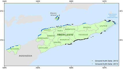 This dataset contains singlebeam bathymetry data acquired during small-boat surveys conducted from October 20-26, 2012 and June 4-27, 2013 in Timor-Leste by the NOAA Coral Reef Ecosystem Program (CREP). Data was acquired with a HydroLite-TM Echosounder Ki...
Benthic percent cover derived from analysis of benthic images collected at coral reef sites in Timor-Leste in 2013 and 2014 (NCEI Accession 0168620)
Satellite-derived bathymetry for nearshore benthic habitats in Timor-Leste from 2010-02-09 to 2013-10-02 (NCEI Accession 0169504)
Coral reef fish biomass and benthic cover data from Timor-Leste in June 2013 (NCEI Accession 0165354)
Benthic images collected at coral reef sites in Timor-Leste from 2012-10-15 to 2014-10-09 (NCEI Accession 0166378)
Nearshore benthic habitats of Timor-Leste derived from WorldView-2 satellite imagery from 2010-02-09 to 2013-12-14 (NCEI Accession 0168914)
Water temperature data from subsurface temperature recorders (STRs) deployed at coral reef sites in Timor-Leste from 2012-10-15 to 2014-10-09 (NCEI Accession 0168931)
This dataset contains singlebeam bathymetry data acquired during small-boat surveys conducted from October 20-26, 2012 and June 4-27, 2013 in Timor-Leste by the NOAA Coral Reef Ecosystem Program (CREP). Data was acquired with a HydroLite-TM Echosounder Ki...
Benthic percent cover derived from analysis of benthic images collected at coral reef sites in Timor-Leste in 2013 and 2014 (NCEI Accession 0168620)
Satellite-derived bathymetry for nearshore benthic habitats in Timor-Leste from 2010-02-09 to 2013-10-02 (NCEI Accession 0169504)
Coral reef fish biomass and benthic cover data from Timor-Leste in June 2013 (NCEI Accession 0165354)
Benthic images collected at coral reef sites in Timor-Leste from 2012-10-15 to 2014-10-09 (NCEI Accession 0166378)
Nearshore benthic habitats of Timor-Leste derived from WorldView-2 satellite imagery from 2010-02-09 to 2013-12-14 (NCEI Accession 0168914)
Water temperature data from subsurface temperature recorders (STRs) deployed at coral reef sites in Timor-Leste from 2012-10-15 to 2014-10-09 (NCEI Accession 0168931)