CRED Coral Reef Early Warning System (CREWS) Enhanced Buoy, Sea Surface Temperature and Conductivity Recorder (SBE37); PRIA, PAL; Long: -162.10283, Lat: 05.88468 (WGS84); Sensor Depth: 1.00m; Data Range: 20020315-20021023.
CREWS Enhanced (CREWS-ENH) buoys are equipped to measure sea surface water temperature and conductivity (Sea-Bird Model SBE37-SM, Sea-Bird Electronics, Inc., www.seabird.com); PAR, UV305 nm, UV330 nm and UV380 nm (Biospherical BIC2104U) at 1 m (nominal) b...
CRED Coral Reef Early Warning System (CREWS) Enhanced Buoy, Sea Surface Temperature and Conductivity Recorder (SBE37); PRIA, PAL; Long: -162.10289, Lat: 05.88463 (WGS84); Sensor Depth: 1.00m; Data Range: 20080401-20100410.
CREWS Enhanced (CREWS-ENH) buoys are equipped to measure sea surface water temperature and conductivity (Sea-Bird Model SBE37-SM, Sea-Bird Electronics, Inc., www.seabird.com); PAR, UV305 nm, UV330 nm and UV380 nm (Biospherical BIC2104U) at 1 m (nominal) b...
CRED Coral Reef Early Warning System (CREWS) Enhanced Buoy, Supplemental Sea Surface Temperature Recorder (SBE39); PRIA, PAL; Long: -162.10289, Lat: 05.88463 (WGS84); Sensor Depth: 1.00m; Data Range: 20080401-20090515.
CREWS Enhanced (CREWS-ENH) buoys are equipped to measure sea surface water temperature and conductivity (Sea-Bird Model SBE37-SM, Sea-Bird Electronics, Inc., www.seabird.com); PAR, UV305 nm, UV330 nm and UV380 nm (Biospherical BIC2104U) at 1 m (nominal) b...
CRED Coral Reef Early Warning System (CREWS) Enhanced Buoy, Sea Surface Temperature and Conductivity Recorder (SBE37); PRIA, PAL; Long: -162.10280, Lat: 05.88468 (WGS84); Sensor Depth: 1.00m; Data Range: 20060326-20080401.
CREWS Enhanced (CREWS-ENH) buoys are equipped to measure sea surface water temperature and conductivity (Sea-Bird Model SBE37-SM, Sea-Bird Electronics, Inc., www.seabird.com); PAR, UV305 nm, UV330 nm and UV380 nm (Biospherical BIC2104U) at 1 m (nominal) b...
CRED Coral Reef Early Warning System (CREWS) Enhanced Buoy, Supplemental Sea Surface Temperature Recorder (SBE39); PRIA, PAL; Long: -162.10280, Lat: 05.88468 (WGS84); Sensor Depth: 1.00m; Data Range: 20060326-20071017.
CREWS Enhanced (CREWS-ENH) buoys are equipped to measure sea surface water temperature and conductivity (Sea-Bird Model SBE37-SM, Sea-Bird Electronics, Inc., www.seabird.com); PAR, UV305 nm, UV330 nm and UV380 nm (Biospherical BIC2104U) at 1 m (nominal) b...
CRED Coral Reef Early Warning System (CREWS) Enhanced Buoy, Sea Surface Temperature and Conductivity Recorder (SBE37); PRIA, PAL; Long: -162.10282, Lat: 05.88467 (WGS84); Sensor Depth: 1.00m; Data Range: 20040330-20060325.
CREWS Enhanced (CREWS-ENH) buoys are equipped to measure sea surface water temperature and conductivity (Sea-Bird Model SBE37-SM, Sea-Bird Electronics, Inc., www.seabird.com); PAR, UV305 nm, UV330 nm and UV380 nm (Biospherical BIC2104U) at 1 m (nominal) b...
CRED Coral Reef Early Warning System (CREWS) Enhanced Buoy, Supplemental Sea Surface Temperature Recorder (SBE39); PRIA, PAL; Long: -162.10282, Lat: 05.88467 (WGS84); Sensor Depth: 1.00m; Data Range: 20040330-20060325.
CREWS Enhanced (CREWS-ENH) buoys are equipped to measure sea surface water temperature and conductivity (Sea-Bird Model SBE37-SM, Sea-Bird Electronics, Inc., www.seabird.com); PAR, UV305 nm, UV330 nm and UV380 nm (Biospherical BIC2104U) at 1 m (nominal) b...
CRED Reson 8101 multibeam backscatter data of Palmyra Atoll, Pacific Remote Island Areas, Central Pacific with 1 meter resolution in netCDF format
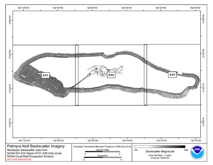
Multibeam backscatter imagery extracted from gridded bathymetry of the lagoon, shelf, and slope environments of Palmyra
Atoll, Pacific Island Areas, Central Pacific. These data provide coverage between 4 and 3500 meters. The backscatter dataset
includes d...
CRED Reson 8101 multibeam backscatter data of Palmyra Atoll, Pacific Remote Island Areas, Central Pacific with 1 meter resolution in GeoTIFF format
Multibeam backscatter imagery extracted from gridded bathymetry of the lagoon, shelf, and slope environments of Palmyra
Atoll, Pacific Island Areas, Central Pacific. These data provide coverage between 4 and 3500 meters. The backscatter dataset
includes d...
CRED Simrad em300 multibeam backscatter data of Palmyra Atoll, Pacific Remote Island Areas, Central Pacific with 5 meter resolution in netCDF format
Multibeam backscatter imagery extracted from gridded bathymetry of the lagoon, shelf, and slope environments of Palmyra
Atoll, Pacific Island Areas, Central Pacific. These data provide coverage between 4 and 3500 meters. The backscatter dataset
includes d...
 CRED Coral Reef Early Warning System (CREWS) Enhanced Buoy, Sea Surface Temperature and Conductivity Recorder (SBE37); PRIA, PAL; Long: -162.10283, Lat: 05.88468 (WGS84); Sensor Depth: 1.00m; Data Range: 20020315-20021023.
 CRED Coral Reef Early Warning System (CREWS) Enhanced Buoy, Sea Surface Temperature and Conductivity Recorder (SBE37); PRIA, PAL; Long: -162.10289, Lat: 05.88463 (WGS84); Sensor Depth: 1.00m; Data Range: 20080401-20100410.
 Multibeam backscatter imagery extracted from gridded bathymetry of the lagoon, shelf, and slope environments of Palmyra
Atoll, Pacific Island Areas, Central Pacific. These data provide coverage between 4 and 3500 meters. The backscatter dataset
includes d...
Multibeam backscatter imagery extracted from gridded bathymetry of the lagoon, shelf, and slope environments of Palmyra
Atoll, Pacific Island Areas, Central Pacific. These data provide coverage between 4 and 3500 meters. The backscatter dataset
includes d...