CRED 5m Gridded multibeam bathymetry of Guam Island, Guam U.S.
Territory
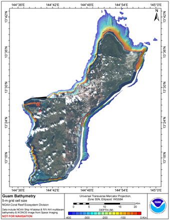
Gridded bathymetry shelf, bank and slope environments of
Guam Island, Guam U.S. Territory. Bottom coverage was achieved in
depths between 0 and -3532 meters but this 5-m grid only includes
coverage to -400 m depths. The netCDF and Arc ASCII grids
include...
CRED REA Algal Assessments at Guam, Marianas Archipelago in 2007
Twelve quadrats were sampled along 2 consecutively-placed, 25m transect lines, as part of Rapid Ecological Assessments, conducted at 10 sites at Guam in the Marianas Archipelago from 12 - 22 May 2007, aboard the NOAA ship Hi'ialakai, during the Reef Asses...
CRED REA Line Point Intercept Surveys of Benthic Parameter Assessments at Guam Island, Marianas Archipelago in 2005
To support a long-term NOAA Coral Reef Conservation Program (CRCP) for sustainable management and conservation of coral reef ecosystems, from 3 - 9 October 2005, line point intercept (LPI) surveys of benthic parameter assessments were conducted, as a part...
CRED REA Line Point Intercept Surveys of Benthic Parameter Assessments at Guam Island, Marianas Archipelago in 2007
To support a long-term NOAA Coral Reef Conservation Program (CRCP) for sustainable management and conservation of coral reef ecosystems, from 12 - 22 May 2007, line point intercept (LPI) surveys of benthic parameter assessments were conducted, as a part o...
CRED REA Line Point Intercept Surveys of Benthic Parameter Assessments at Guam Island, Marianas Archipelago in 2009
To support a long-term NOAA Coral Reef Conservation Program (CRCP) for sustainable management and conservation of coral reef ecosystems, from 5 April - 14 April 2009, line point intercept (LPI) surveys of benthic parameter assessments were conducted, as a...
CRED REA Coral Population Parameters at Guam, 2005
Belt transects along 1 or 2 consecutively-placed, 25m transect lines were
surveyed as part of Rapid Ecological Assessments conducted at 9 sites at
Guam and 2 sites at Santa Rosa Bank in October, 2005 from the NOAA vessel
Oscar Elton Sette (OES05-12). Raw ...
CRED REA Coral Population Parameters at Guam, Marianas Archipelago, 2007
Belt transects along 2 consecutively-placed, 25m transect lines were surveyed as part of Rapid Ecological
Assessments conducted at 10 sites at Guam in the Marianas Archipelago (MA) during 12 - 22 May 2007 in the NOAA
Hi'ialakai Reef Assessment and Monitor...
CRED REA Belt Surveys of Coral Population and Disease Assessments at Guam Island, Marianas Archipelago in 2009
To support a long-term NOAA Coral Reef Conservation Program (CRCP) for sustainable management and conservation of coral reef ecosystems, from 5 April - 14 April 2009, belt transect surveys of coral population and diseases quantitative assessments were con...
CRED REA Fish Team Belt Transect Survey at Guam, 2003
Belt transects along 3 consecutively-placed, 25m transect lines were
surveyed as part of Rapid Ecological Assessments conducted at 9 sites at
Guam in the Commonwealth of the Northern Mariana Islands (CNMI) in
September, 2003 from the NOAA vessel Oscar Elt...
 CRED Acoustic Backscatter Guam 2003, Imagery Extracted from Gridded Bathymetry
 Gridded bathymetry shelf, bank and slope environments of
Guam Island, Guam U.S. Territory. Bottom coverage was achieved in
depths between 0 and -3532 meters but this 5-m grid only includes
coverage to -400 m depths. The netCDF and Arc ASCII grids
include...
Gridded bathymetry shelf, bank and slope environments of
Guam Island, Guam U.S. Territory. Bottom coverage was achieved in
depths between 0 and -3532 meters but this 5-m grid only includes
coverage to -400 m depths. The netCDF and Arc ASCII grids
include...
 CRED REA Algal Assessments at Guam, Marianas Archipelago in 2007