 Preliminary hard and soft bottom seafloor substrate map
derived from gridded sidescan and bathymetry derivatives at
Apra Harbor, Guam U.S. Territory.
Preliminary hard and soft bottom seafloor substrate map
derived from gridded sidescan and bathymetry derivatives at
Apra Harbor, Guam U.S. Territory.
 Preliminary hard and soft seafloor substrate map classified
from sidescan data and bathymetric derivatives at Apra Harbor, Guam U.S. Territory.
The dataset was created using Bathymetric Position Index (bpi) zones derived from Reson SeaBat 8125 multibeam d...
Preliminary hard and soft seafloor substrate map classified
from sidescan data and bathymetric derivatives at Apra Harbor, Guam U.S. Territory.
The dataset was created using Bathymetric Position Index (bpi) zones derived from Reson SeaBat 8125 multibeam d...
 Gridded bathymetry from Apra Harbor, Guam U.S. Territory. The netCDF and Arc
ASCII grids include multibeam bathymetry from the Reson SeaBat 8125 multibeam sonar
collected in 2008 by the NOAA Office of Coast Survey and the United States Navy Fleet
Survey T...
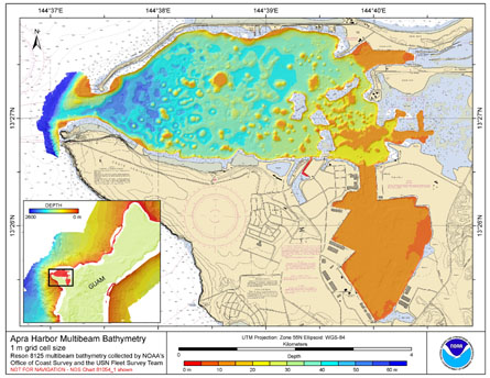
Gridded bathymetry from Apra Harbor, Guam U.S. Territory. The netCDF and Arc
ASCII grids include multibeam bathymetry from the Reson SeaBat 8125 multibeam sonar
collected in 2008 by the NOAA Office of Coast Survey and the United States Navy Fleet
Survey T...
 Rugosity is derived from gridded (1 m cell size)
multibeam bathymetry, collected aboard the Survey Vessel
Swamp Fox using the Terrain Modeler with rugosity methods
by Jeff Jenness (2003). Cell values reflect the surface area/planimetric area
ratio for the...
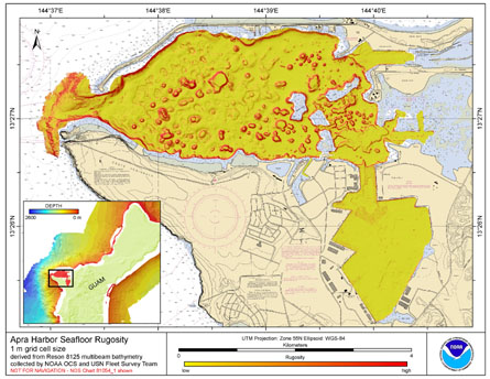
Rugosity is derived from gridded (1 m cell size)
multibeam bathymetry, collected aboard the Survey Vessel
Swamp Fox using the Terrain Modeler with rugosity methods
by Jeff Jenness (2003). Cell values reflect the surface area/planimetric area
ratio for the...
 Slope is derived from gridded (1 m cell size) multibeam
bathymetry, collected aboard the Survey Vessel Swamp Fox. Cell
values reflect the maximum rate of change (in degrees) in elevation
between neighboring cells derived with the ArcGIS Spatial Analyst
ex...
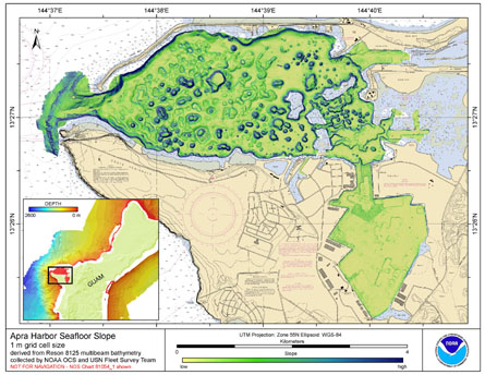
Slope is derived from gridded (1 m cell size) multibeam
bathymetry, collected aboard the Survey Vessel Swamp Fox. Cell
values reflect the maximum rate of change (in degrees) in elevation
between neighboring cells derived with the ArcGIS Spatial Analyst
ex...
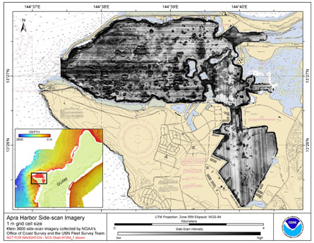 Gridded side-scan imagery collected in Apra Harbor, Guam U.S. Territory, USA. The GeoTIFF and
Arc ASCII file includes data that were collected using a Klein 3000 high-resolution side-scan sonar system
with dual operating frequencies of 100 and 500 kHz. Th...
Gridded side-scan imagery collected in Apra Harbor, Guam U.S. Territory, USA. The GeoTIFF and
Arc ASCII file includes data that were collected using a Klein 3000 high-resolution side-scan sonar system
with dual operating frequencies of 100 and 500 kHz. Th...