 Rugosity 10 m grid derived from gridded bathymetry of Asuncion Island,
Commonwealth of the Northern Mariana Islands (CNMI), USA
Rugosity 10 m grid derived from gridded bathymetry of Asuncion Island,
Commonwealth of the Northern Mariana Islands (CNMI), USA
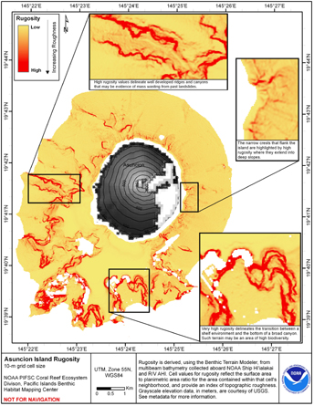 Rugosity is derived from gridded (10 m cell size)
multibeam bathymetry collected aboard NOAA Ship Hiialaka'i and
R/V AHI, using the Benthic Terrain Modeler with rugosity methods by
Jeff Jenness (2003). Cell values reflect the surface area to planimetric
a...
Rugosity is derived from gridded (10 m cell size)
multibeam bathymetry collected aboard NOAA Ship Hiialaka'i and
R/V AHI, using the Benthic Terrain Modeler with rugosity methods by
Jeff Jenness (2003). Cell values reflect the surface area to planimetric
a...
 This data set was retrieved from the USGS rockyftp website and processed to NOAA/OCM's Digital Coast.
Product: These lidar data are processed Classified LAS 1.4 files, formatted to 4,376 individual 1500 m x 1500 m tiles; used to create intensity images,...
This data set was retrieved from the USGS rockyftp website and processed to NOAA/OCM's Digital Coast.
Product: These lidar data are processed Classified LAS 1.4 files, formatted to 4,376 individual 1500 m x 1500 m tiles; used to create intensity images,...
 Product: These lidar data are processed Classified LAS 1.4 files, formatted to 301 individual 1500 m x 1500 m tiles; used to create intensity images, 3D breaklines and hydro-flattened DEMs as necessary.
Geographic Extent: St. Croix, US Virgin Isla...
Product: These lidar data are processed Classified LAS 1.4 files, formatted to 301 individual 1500 m x 1500 m tiles; used to create intensity images, 3D breaklines and hydro-flattened DEMs as necessary.
Geographic Extent: St. Croix, US Virgin Isla...